Monterey Bay Coastal Recreational Trail
Recreational trail in a popular area of the California coast
| Monterey Bay Coastal Recreation Trail | |
|---|---|
 | |
| Length | 18 miles (29 km) |
| Use | Hiking, biking |
| Elevation gain/loss | 320 feet (98 m) gain approximately[1] |
| Difficulty | Easy |
| Season | All |
| Sights | Asilomar State Beach, Asilomar State Marine Reserve, Cannery Row, Edward F. Ricketts State Marine Conservation Area, Fisherman's Wharf, Fort Ord Dunes State Park, Lovers Point State Marine Reserve, Monterey Bay, Marina State Beach, Monterey State Beach, Monterey Bay Aquarium, Pacific Grove Marine Gardens State Marine Conservation Area, Pacific Grove Municipal Golf Links, Point Pinos Lighthouse, Presidio |
| Surface | Asphalt |
| Website | Official website |
The Monterey Bay Coastal Recreation Trail (or Monterey Bay Coastal Trail for short) is a trail that runs along the coast of the Monterey Bay. It stretches for 18 miles, between Castroville, California and Pacific Grove, California, and passes several tourist attractions along the way, including Cannery Row, the Monterey Bay Aquarium, and Fisherman's Wharf.
History
Much of the Monterey Bay Coastal Recreation Trail follows the former route of the Southern Pacific Railroad, which connected Castroville to Fisherman's Wharf and Cannery Row.[2] When the railroad was abandoned, the Monterey Peninsula Regional Park District partnered with the Coastal Conservancy, as well as the cities of Pacific Grove, Monterey, and Seaside, to create the coastal trail in 1986.[3]
-
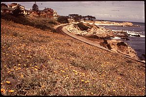 Historical photo of the Southern Pacific Railroad route, near Lovers Point Beach in Pacific Grove, from May 1972, by Dick Rowan for NARA (National Archives and Records Administration). The railroad track has since been replaced with the Monterey Bay Coastal Trail.
 -
 Reproduction of the same historical photograph 50 years later, June 2022, taken from the same physical location, showing the Monterey Bay Coastal Trail where the old railroad bed is.


Activities
The trail supports a range of activities.[2] The trail itself supports walking, jogging, and biking. The trail also connects to multiple beaches, and passes many local restaurants and businesses. There are also grassy areas and tables for picnics at various points along the trail. Several businesses along the trail offer bicycle, kayak, surfboard, scuba, and paddle rentals. There are plentiful scenic views of the Monterey Bay and ample opportunities for wildlife viewing.[3][2]
References
- ^ "Monterey Bay Coastal Trail". All Trails. Retrieved 5 July 2022.
- ^ a b c "City of Monterey, CA". City of Monterey. Retrieved 28 June 2022.
- ^ a b "Monterey Bay Coastal Recreation Trail". See Monterey. Retrieved 27 June 2022.
External links
![]() Media related to Monterey Bay Coastal Recreational Trail at Wikimedia Commons
Media related to Monterey Bay Coastal Recreational Trail at Wikimedia Commons
- v
- t
- e
| Historic buildings |
|
|---|---|
| Historic mission churches | |
| Literary sites |
|
| Art |
|
|---|---|
| History | |
| Science |
- Casa del Oro Sensory and Herb Garden
- Casa Soberanes Garden
- Custom House Cactus Garden
- First Theater in California Garden
- Lester Rowntree Native Plant Garden
- Memory Garden
- Pacific Grove Marine Gardens State Marine Conservation Area
| Performing arts centers and venues | |
|---|---|
| Annual events and festivals | |
| Sports venues |
| ||
|---|---|---|
| Bodies of water & submarine features |
|  |
| Counties | ||
| Major cities | ||
| Cities and towns 50k-100k | ||
| Cities and towns 25k-50k | ||
| Cities, towns, and census-designated places <25k | ||
| Ghost towns | ||
 | This Monterey County, California-related article is a stub. You can help Wikipedia by expanding it. |
- v
- t
- e


