Mount Bagot
Mountain in Alaska, United States of America


Mount Bagot
Location of Mt. Bagot in British Columbia
Show map of British Columbia
Mount Bagot
Mount Bagot (Canada)
Show map of CanadaAlaska, United States
Boundary Ranges
USGS Skagway B-1[4]
Mount Bagot is a 2,181-metre (7,156-foot) mountain summit located on, and in part defining, the international border between British Columbia, Canada, and Alaska, United States.
Description
Mount Bagot, also known as Boundary Peak 107,[5] is located in the Boundary Ranges of the Coast Mountains. The true summit is set 200 metres inside Canada and the lower Southwest Peak (7,087+ ft, 2,160+ m) lies directly on the border, 0.25 mi (0.40 km) from the main summit.[6] The Southwest Peak is situated 13 miles (21 km) southeast of Skagway on the boundary shared by Haines Borough and Skagway Borough,[4] and on land managed by Tongass National Forest.[6] Although modest in elevation, relief is significant as the west slope rises 1,720 metres (5,650 ft) in two kilometres (1.2 mile). Precipitation runoff and glacial meltwater from the mountain drains to Lynn Canal via the Katzehin River. The nearest higher neighbor is the Sawtooth Range, four miles (6.5 km) to the north.[1] The first ascent of the summit was made on August 31, 1967, by Kenneth Carpenter, Ron Miller, Margaret Piggott, and Mike Wiley.[5]
Etymology
The mountain was named jointly by the United States and Canada to honor Sir Charles Bagot (1781–1843), British Ambassador to Russia and plenipotentiary at St. Petersburg in 1822 during negotiations regarding the Alaska boundary.[7] He was the British Minister to the United States (1815–1820) and negotiated the Rush–Bagot Treaty in 1817.[4] He served as Governor General of Canada from 1841 through 1843. The toponym was officially adopted on May 2, 1923, by the U.S. Board on Geographic Names,[4] and on March 31, 1924, by the Geographical Names Board of Canada.[3]
Climate
Based on the Köppen climate classification, Mount Bagot is located in a tundra climate zone with cold, snowy winters, and cool summers.[8] Weather systems coming off the Gulf of Alaska are forced upwards by the Coast Mountains (orographic lift), causing heavy precipitation in the form of rainfall and snowfall. Winter temperatures can drop below −20 °C with wind chill factors below −30 °C. This climate supports the Denver Glacier and other unnamed glaciers of the Juneau Icefield surrounding the mountain.
See also
Gallery
-
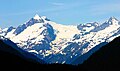 Mount Bagot (left) viewed looking through the Katzehin River Valley
 -
 Aerial view of southwest aspect of Mt. Bagot centered on the skyline
 -
 Charles Bagot in 1825


References
- ^ a b c d "Mount Bagot, British Columbia". Peakbagger.com. Retrieved 2024-01-29.
- ^ a b "Mount Bagot". Geographical Names Data Base. Natural Resources Canada. Retrieved 2024-01-29.
- ^ a b "Mount Bagot". BC Geographical Names. Retrieved 2024-01-29.
- ^ a b c d "Mount Bagot". Geographic Names Information System. United States Geological Survey, United States Department of the Interior. Retrieved 2024-01-29.
- ^ a b North America, United States, Alaska, Boundary Peaks, Denver and Meade Glaciers, Southeast of Skagway, Kenneth C. Carpenter, American Alpine Journal, 1968.
- ^ a b "Mount Bagot - Southwest Peak, Alaska/British Columbia". Peakbagger.com. Retrieved 2024-01-29.
- ^ Donald J. Orth, Dictionary of Alaska Place Names, U.S. Government Printing Office, 1967, page 99.
- ^ Peel, M. C.; Finlayson, B. L. & McMahon, T. A. (2007). "Updated world map of the Köppen−Geiger climate classification". Hydrol. Earth Syst. Sci. 11 (5): 1633. Bibcode:2007HESS...11.1633P. doi:10.5194/hess-11-1633-2007. ISSN 1027-5606.
External links
- Mount Bagot: weather forecast
- Account of first ascent: publications.americanalpineclub.org
Portals:
 Mountains
 Geography
 Alaska


- v
- t
- e
- Chutine
- Cinder
- Devils Paw
- Devils Thumb
- Dipyramid
- Hoodoo
- Ibex
- Iskut Canyon
- Kates Needle
- King Creek
- Little Bear
- London
- Nesselrode
- Ratz
- Seconed Canyon
- Snippaker Creek
- The Volcano


