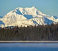
Mount Bertha
Mountain in Alaska


Mount Bertha
Location of Mount Bertha in Alaska
Saint Elias Mountains[1]
Mount Bertha is a 10,204-foot (3,110 meter) glaciated mountain summit located in the Fairweather Range of the Saint Elias Mountains, in southeast Alaska, United States.
Geography and naming
The peak is situated in Glacier Bay National Park, 5.5 mi (9 km) east-northeast of Mount Crillon which is the nearest higher peak, and 23.5 mi (38 km) southeast of Mount Fairweather, which is the highest peak in the Fairweather Range. The mountain's name first appeared in 1910 when published by the United States Coast and Geodetic Survey.[3] The United States Geological Survey claims it was named after SS Bertha, an Alaska Commercial Company steamer in service from 1888 until it wrecked at Uyak Bay on July 18, 1915.[4] However, according to Bradford Washburn of the Boston Museum of Science and American Mountaineering Museum, this feature was named for a prostitute in Skagway, Alaska, known by members of the International Boundary Commission who surveyed the area.[5]
Climbing history
The first ascent of the peak was made July 30, 1940, by Bradford Washburn, his wife Barbara Washburn, Maynard Miller, Michl Feuersinger, and Thomas Winship.[6] It was the first mountain climbing experience for Barbara, and Bradford would later refer to the expedition as their honeymoon since they had recently married in April. After the expedition she would learn that she was several months pregnant. In 1947 she became the first woman to summit Denali. The months May through June offer the most favorable weather for climbing and viewing.
Climate
Based on the Köppen climate classification, Mount Bertha has a subarctic climate with cold, snowy winters, and mild summers.[7] Weather systems coming off the Gulf of Alaska are forced upwards by the Fairweather Range (orographic lift), causing heavy precipitation in the form of rainfall and snowfall. Winter temperatures can drop below −20 °C with wind chill factors below −30 °C. This climate supports hanging glaciers on its slopes as well as the immense Brady Glacier to the south, Reid Glacier to the northeast, and Johns Hopkins Glacier to the northwest. Precipitation runoff and meltwater from its glaciers drains into Glacier Bay and the Gulf of Alaska.
See also
Gallery
-
-
 Mt. Crillon (left) and Mt. Bertha (right) seen from park headquarters
 -
 Bertha's summit detail, from northwest
 -
 Bertha upper left with Mt. Crillon and Johns Hopkins Glacier. by Austin Post 1973
 -
 by Austin Post 1972
 -
 Bertha in front of Crillon
 -
 East aspect of Mount Bertha with Mt. Crillon partially visible behind


References
- ^ a b c d "Mount Bertha, Alaska". Peakbagger.com. Retrieved 2020-01-22.
- ^ a b "Bertha, Moun - 10,204' AK". listsofjohn.com. Retrieved 2024-04-06.
- ^ "Mount Bertha". Geographic Names Information System. United States Geological Survey, United States Department of the Interior. Retrieved 2020-01-22.
- ^ Mount Bertha, National Park Service
- ^ Bradford Washburn with Lew Freedman, Bradford Washburn An Extraordinary Life The Autobiography of a Mountaineering Icon, 2005, Westwinds Press, chapter 12.
- ^ American Alpine Journal, Ascent of Mount Bertha, Publication Year: 1941
- ^ Peel, M. C.; Finlayson, B. L.; McMahon, T. A. (2007). "Updated world map of the Köppen−Geiger climate classification". Hydrol. Earth Syst. Sci. 11. ISSN 1027-5606.
External links
 Alaska portal
 Mountains portal


- Weather forecast: Mount Bertha
- Account of first ascent: American Alpine Club
- Photo of SS Bertha shipwreck: Alaska State Library-Historical Collections
- Fairweather Range webcam: National Park Service (Mt. Bertha centered in the distance - on a rare clear day)
Places adjacent to Mount Bertha | |
|---|---|


