Mushin, Lagos
Suburb of Lagos and local government area in Nigeria
LGA and suburb in Lagos State, Nigeria
Mushin | |
|---|---|
LGA and suburb | |
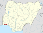
 Location of Mushin within Lagos Metropolitan Area | |
| Country |  Nigeria Nigeria |
| State | Lagos State |
| Area | |
| • Total | 7 sq mi (17 km2) |
| Population (2022)[1] | |
| • Total | 935,400 |
| • Density | 140,000/sq mi (55,000/km2) |
| Time zone | UTC+1 (WAT) |
 | |
Mushin is a Local Government Area in Lagos.[2] It is located 10 km north of the city core, adjacent to the main road to Ikeja, and is largely a congested residential area with inadequate sanitation and low-quality housing. It had 633,009 inhabitants at the 2006 Census.[3] It is also where a lot of a list talents have risen from, artists such as Wande Coal
Infrastructure and demographics
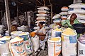
After the 1960 independence from Great Britain, there were large migrations to the suburban areas. This led to intensive overcrowding. As a result, poor sanitation and inadequate housing led to poor living conditions. However, since the rise of industrialization in Nigeria, Mushin has become one of the largest beneficiaries of the industrial expansion. Much in has local commercial enterprises which include: spinning and weaving of cotton, shoe manufacturing, bicycle and motorised-cycle assembly, along with the production of powdered milk. Once a staple source of revenue in Nigeria, Agriculture is also a large central market.
The town is home to Hospitals as well as Educational facilities that extend to the secondary school level. Mushin lies at the intersection of roads from Lagos, Shomolu, and Ikeja. Most of its inhabitants are from the Yoruba tribe, and as a result Yoruba is the commonest language spoken.[4][5]
Boundary
- North – Oshodi/Apapa expressway from Oshodi to flyover leading to international airport to Oshodi exit into Agege motor road
- South – Boundary with Surulere Local Government at the other side of Bishop Street to include Akobi crescent, LUTH, Idi-Araba communities
- East – Agege motor road from Oshodi to Bishop street
- West – Oshodi – Apapa Expressway to Itire junction to include Itire-Ijesha communities in former Mushin Local Government.
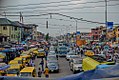
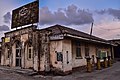
Gallery


References
- ^ "Lagos State: Subdivisions". www.citypopulation.de. Retrieved 2024-02-05.
- ^ "Mushin". NigeriaCongress.org. Archived from the original on January 11, 2021. Retrieved 2007-04-08.
- ^ "Nigeria Census - Nigeria Data Portal". nigeria.opendataforafrica.org. Retrieved 2023-03-06.
- ^ "Mushin | Nigeria". Retrieved 2015-05-22.
- ^ "Mushin | Nigeria | Britannica". www.britannica.com. Retrieved 2023-03-01.
External links
Wikimedia Commons has media related to Mushin, Nigeria.
- v
- t
- e
State capital: Ikeja
| Island | |
|---|---|
| Mainland | |
| Suburban |
- Adeniran Ogunsanya College of Education
- Augustine University Ilara
- Caleb University
- CMS Grammar School, Lagos
- College of Medicine, University of Lagos
- Federal College of Education (Technical), Akoka
- Federal College of Fisheries and Marine Technology
- Igbobi College
- Ikenna Stars Academy
- King's College, Lagos
- Lagos City Polytechnic
- Lagos State University
- Lagos State University College of Medicine
- Pan-Atlantic University
- Queen's College, Lagos
- St Gregory's College, Lagos
- University of Lagos
- Yaba College of Technology
See also: List of schools in Lagos
| Trade & commerce | |
|---|---|
| Ports | |
| Shopping malls |
- Federal Medical Centre Ebute Metta
- First Consultant Hospital
- Lagos Island General Hospital
- Reddington Hospital
- Eko Hospital
- St. Nicholas Hospital, Lagos
- Lagoon Hospitals
- Lagos University Teaching Hospital
- National Orthopaedic Hospital
- Creek Hospital
- Flying Doctors Nigeria
- Yaba Psychiatric Hospital
See also: List of hospitals in Lagos
| Newspapers |
|
|---|---|
| Television |
|
| Radio |
| Events | |
|---|---|
| Landmarks | |
| Sports venues | |
| Parks |
|
| Buildings and structures |
See also: Architecture of Lagos |
 Category
 Commons
 Nigeria portal


Authority control databases | |
|---|---|
| International |
|
| National |
|
6°32′N 3°21′E / 6.533°N 3.350°E / 6.533; 3.350
 | This Lagos State location article is a stub. You can help Wikipedia by expanding it. |
- v
- t
- e


