National Register of Historic Places listings in Collin County, Texas

This is a list of the National Register of Historic Places listings in Collin County, Texas.
This is intended to be a complete list of properties and districts listed on the National Register of Historic Places in Collin County, Texas. There are seven districts, 62 individual properties, and one former property listed on the National Register in the county. Sixteen individually listed properties are Recorded Texas Historic Landmarks while four districts contain many more including one that is also a State Antiquities Landmark.
This National Park Service list is complete through NPS recent listings posted April 12, 2024.[1]
Current listings
Map all coordinates using OpenStreetMap
Download coordinates as:
- KML
- GPX (all coordinates)
- GPX (primary coordinates)
- GPX (secondary coordinates)
The publicly disclosed locations of National Register properties and districts may be seen in a mapping service provided.[2]
| [3] | Name on the Register[4] | Image | Date listed[5] | Location | City or town | Description |
|---|---|---|---|---|---|---|
| 1 | Allen Water Station |  | December 3, 2009 (#09000980) | North of Exchange parkway on Cottonwood Creek 33°07′02″N 96°39′58″W / 33.11725°N 96.666008°W / 33.11725; -96.666008 (Allen Water Station) | Allen | |
| 2 | Aston Building | 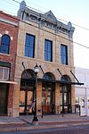 | June 30, 1983 (#83003131) | 113 S. Main St. 33°09′46″N 96°21′34″W / 33.162778°N 96.359444°W / 33.162778; -96.359444 (Aston Building) | Farmersville | Part of Farmersville Commercial Historic District |
| 3 | Beverly-Harris House |  | October 8, 1987 (#87001661) | 604 Parker 33°11′36″N 96°37′19″W / 33.193333°N 96.621944°W / 33.193333; -96.621944 (Beverly-Harris House) | McKinney | Recorded Texas Historic Landmark; Historic Resources of McKinney MPS |
| 4 | John H. Bingham House |  | June 27, 1988 (#87001662) | 800 S. Chestnut 33°11′24″N 96°36′50″W / 33.19°N 96.613889°W / 33.19; -96.613889 (John H. Bingham House) | McKinney | Historic Resources of McKinney MPS |
| 5 | Board-Everett House |  | October 8, 1987 (#87001663) | 507 N. Bradley 33°12′08″N 96°37′24″W / 33.202222°N 96.623333°W / 33.202222; -96.623333 (Board-Everett House) | McKinney | Historic Resources of McKinney MPS |
| 6 | John R. Brown House |  | October 8, 1987 (#87001666) | 509 N. Church 33°12′06″N 96°37′02″W / 33.201667°N 96.617222°W / 33.201667; -96.617222 (John R. Brown House) | McKinney | Historic Resources of McKinney MPS |
| 7 | Burrus-Finch House |  | June 27, 1988 (#87001671) | 405 N. Waddill 33°12′03″N 96°37′36″W / 33.200833°N 96.626667°W / 33.200833; -96.626667 (Burrus-Finch House) | McKinney | Historic Resources of McKinney MPS |
| 8 | Celina Public School |  | October 14, 2009 (#09000839) | 205 S. Colorado St. 33°19′23″N 96°47′16″W / 33.323136°N 96.787836°W / 33.323136; -96.787836 (Celina Public School) | Celina | |
| 9 | U. P. Clardy House |  | October 8, 1987 (#87001679) | 315 Oak 33°12′00″N 96°37′27″W / 33.2°N 96.624167°W / 33.2; -96.624167 (U. P. Clardy House) | McKinney | Historic Resources of McKinney MPS |
| 10 | Cline-Bass House |  | June 27, 1988 (#87001681) | 804 Tucker 33°12′10″N 96°37′33″W / 33.202778°N 96.625833°W / 33.202778; -96.625833 (Cline-Bass House) | McKinney | Historic Resources of McKinney MPS |
| 11 | J. R. Coggins House |  | October 8, 1987 (#87001682) | 805 Howell 33°11′40″N 96°37′18″W / 33.194444°N 96.621667°W / 33.194444; -96.621667 (J. R. Coggins House) | McKinney | Recorded Texas Historic Landmark; Historic Resources of McKinney MPS; also called John Martin House |
| 12 | Collin County Mill and Elevator Company |  | October 8, 1987 (#87001685) | 407 E. Louisiana 33°11′51″N 96°36′34″W / 33.1975°N 96.609444°W / 33.1975; -96.609444 (Collin County Mill and Elevator Company) | McKinney | Historic Resources of McKinney MPS |
| 13 | Crouch-Perkins House |  | October 8, 1987 (#87001691) | 205 N. Church 33°11′53″N 96°36′23″W / 33.198056°N 96.606389°W / 33.198056; -96.606389 (Crouch-Perkins House) | McKinney | Recorded Texas Historic Landmark; Historic Resources of McKinney MPS |
| 14 | H. L. Davis House |  | October 8, 1987 (#87001695) | 705 N. College 33°12′13″N 96°37′15″W / 33.203611°N 96.620833°W / 33.203611; -96.620833 (H. L. Davis House) | McKinney | Recorded Texas Historic Landmark; Historic Resources of McKinney MPS |
| 15 | Davis-Hill House |  | October 8, 1987 (#87001697) | 710 N. Church 33°12′19″N 96°36′59″W / 33.205278°N 96.616389°W / 33.205278; -96.616389 (Davis-Hill House) | McKinney | Historic Resources of McKinney MPS |
| 16 | J. S. Dowell House |  | October 8, 1987 (#87001699) | 608 Parker 33°11′35″N 96°37′20″W / 33.193056°N 96.622222°W / 33.193056; -96.622222 (J. S. Dowell House) | McKinney | Historic Resources of McKinney MPS |
| 17 | Joe E. Dulaney House |  | October 8, 1987 (#87001704) | 311 S. Chestnut 33°11′41″N 96°36′46″W / 33.194722°N 96.612778°W / 33.194722; -96.612778 (Joe E. Dulaney House) | McKinney | Recorded Texas Historic Landmark; Historic Resources of McKinney MPS |
| 18 | Joseph Field Dulaney House |  | October 8, 1987 (#87001702) | 315 S. Chestnut 33°11′40″N 96°36′46″W / 33.194444°N 96.612778°W / 33.194444; -96.612778 (Joseph Field Dulaney House) | McKinney | Recorded Texas Historic Landmark; Historic Resources of McKinney MPS |
| 19 | Estes House | 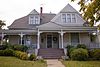 | November 29, 1995 (#95001365) | 903 N. College St. 33°12′16″N 96°37′15″W / 33.204444°N 96.620833°W / 33.204444; -96.620833 (Estes House) | McKinney | Recorded Texas Historic Landmark; Historic Resources of McKinney MPS |
| 20 | F. C. Faires House |  | October 8, 1987 (#87001705) | 505 S. Chestnut 33°11′32″N 96°36′47″W / 33.192222°N 96.613056°W / 33.192222; -96.613056 (F. C. Faires House) | McKinney | Historic Resources of McKinney MPS |
| 21 | Faires-Bell House |  | October 8, 1987 (#87001706) | S side Chestnut Sq. 33°11′40″N 96°36′45″W / 33.194444°N 96.6125°W / 33.194444; -96.6125 (Faires-Bell House) | McKinney | Recorded Texas Historic Landmark; Historic Resources of McKinney MPS |
| 22 | Fairview H&TC Railroad Historic District | Upload image | May 10, 2010 (#10000247) | About 1/4 mi. W of St HWY 5 on Sloan Creek & the former Houston & Texas Central Railroad tracks 33°08′50″N 96°38′28″W / 33.147222°N 96.641111°W / 33.147222; -96.641111 (Fairview H&TC Railroad Historic District) | Fairview | Houston and Texas Central Railway |
| 23 | Farmersville Commercial Historic District |  | February 21, 2017 (#100000670) | Along Main and McKinney Sts. 33°09′48″N 96°21′36″W / 33.163236°N 96.359953°W / 33.163236; -96.359953 (Farmersville Commercial Historic District) | Farmersville | Includes Recorded Texas Historic Landmarks |
| 24 | Farmersville Masonic Lodge No. 214, A.F. and A.M. |  | March 30, 2005 (#05000245) | 101 S. Main St. 33°09′55″N 96°21′35″W / 33.165278°N 96.359722°W / 33.165278; -96.359722 (Farmersville Masonic Lodge No. 214, A.F. and A.M.) | Farmersville | Recorded Texas Historic Landmark; part of Farmersville Commercial Historic District |
| 25 | John H. Ferguson House |  | October 8, 1987 (#87001707) | 607 N. Church 33°12′10″N 96°37′02″W / 33.202778°N 96.617222°W / 33.202778; -96.617222 (John H. Ferguson House) | McKinney | Historic Resources of McKinney MPS |
| 26 | Foote-Crouch House | 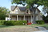 | June 27, 1988 (#87001708) | 401 N. Benge 33°11′40″N 96°37′03″W / 33.194444°N 96.6175°W / 33.194444; -96.6175 (Foote-Crouch House) | McKinney | Historic Resources of McKinney MPS |
| 27 | S. H. Fox House |  | October 8, 1987 (#87001709) | 808 Tucker 33°12′10″N 96°37′32″W / 33.202778°N 96.625556°W / 33.202778; -96.625556 (S. H. Fox House) | McKinney | Historic Resources of McKinney MPS |
| 28 | Jim B. Goodner House |  | October 8, 1987 (#87001688) | 302 S. Tennessee 33°11′42″N 96°36′54″W / 33.195°N 96.615°W / 33.195; -96.615 (Jim B. Goodner House) | McKinney | Historic Resources of McKinney MPS |
| 29 | Gough-Hughston House |  | June 27, 1988 (#87001710) | 1206 W. Louisiana 33°11′50″N 96°37′36″W / 33.197222°N 96.626667°W / 33.197222; -96.626667 (Gough-Hughston House) | McKinney | Recorded Texas Historic Landmark; Historic Resources of McKinney MPS |
| 30 | Heard-Craig House |  | October 8, 1987 (#87001711) | 205 W. Hunt 33°11′55″N 96°37′00″W / 33.198611°N 96.616667°W / 33.198611; -96.616667 (Heard-Craig House) | McKinney | Recorded Texas Historic Landmark; Historic Resources of McKinney MPS |
| 31 | Ben Hill House | 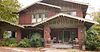 | October 8, 1987 (#87001712) | 509 Tucker 33°12′08″N 96°37′42″W / 33.202222°N 96.628333°W / 33.202222; -96.628333 (Ben Hill House) | McKinney | Historic Resources of McKinney MPS |
| 32 | John B. Hill House |  | October 8, 1987 (#87001713) | 605 N. College 33°12′10″N 96°37′15″W / 33.202778°N 96.620833°W / 33.202778; -96.620833 (John B. Hill House) | McKinney | Historic Resources of McKinney MPS |
| 33 | Moran Hill House |  | October 8, 1987 (#87001714) | 203 N. Waddill 33°11′53″N 96°37′36″W / 33.198056°N 96.626667°W / 33.198056; -96.626667 (Moran Hill House) | McKinney | Historic Resources of McKinney MPS |
| 34 | W. R. Hill House |  | October 8, 1987 (#87001715) | 601 N. College 33°12′09″N 96°37′16″W / 33.2025°N 96.621111°W / 33.2025; -96.621111 (W. R. Hill House) | McKinney | Historic Resources of McKinney MPS |
| 35 | Hill-Webb Grain Elevator | 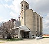 | October 8, 1987 (#87001716) | 400 E. Louisiana 33°11′47″N 96°36′34″W / 33.196389°N 96.609444°W / 33.196389; -96.609444 (Hill-Webb Grain Elevator) | McKinney | Historic Resources of McKinney MPS |
| 36 | House at 1303 W. Louisiana |  | October 8, 1987 (#87001717) | 1303 W. Louisiana 33°11′48″N 96°37′39″W / 33.196667°N 96.6275°W / 33.196667; -96.6275 (House at 1303 W. Louisiana) | McKinney | Historic Resources of McKinney MPS |
| 37 | House at 201 N. Graves |  | October 8, 1987 (#87001718) | 201 N. Graves 33°11′55″N 96°37′47″W / 33.198611°N 96.629722°W / 33.198611; -96.629722 (House at 201 N. Graves) | McKinney | Historic Resources of McKinney MPS |
| 38 | House at 301 E. Lamar | Upload image | October 8, 1987 (#87001719) | 301 E. Lamar 33°12′02″N 96°37′03″W / 33.200556°N 96.6175°W / 33.200556; -96.6175 (House at 301 E. Lamar) | McKinney | Historic Resources of McKinney MPS |
| 39 | House at 610 Tucker | Upload image | October 8, 1987 (#87001720) | 610 Tucker 33°12′10″N 96°37′38″W / 33.202778°N 96.627222°W / 33.202778; -96.627222 (House at 610 Tucker) | McKinney | Historic Resources of McKinney MPS |
| 40 | House at 704 Parker | 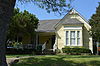 | October 8, 1987 (#87001721) | 704 Parker 33°11′33″N 96°37′20″W / 33.1925°N 96.622222°W / 33.1925; -96.622222 (House at 704 Parker) | McKinney | Historic Resources of McKinney MPS |
| 41 | Houses at 406 and 408 Heard | 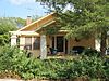 | October 8, 1987 (#87001722) | 406 & 408 Heard 33°12′16″N 96°37′05″W / 33.204444°N 96.618056°W / 33.204444; -96.618056 (Houses at 406 and 408 Heard) | McKinney | Historic Resources of McKinney MPS |
| 42 | John Johnson House | 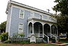 | October 8, 1987 (#87001723) | 302 Anthony 33°11′37″N 96°36′46″W / 33.193611°N 96.612778°W / 33.193611; -96.612778 (John Johnson House) | McKinney | Historic Resources of McKinney MPS |
| 43 | Thomas Johnson House | 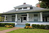 | October 8, 1987 (#87001724) | 312 S. Tennessee 33°11′40″N 96°36′54″W / 33.194444°N 96.615°W / 33.194444; -96.615 (Thomas Johnson House) | McKinney | Historic Resources of McKinney MPS |
| 44 | Mrs. J. C. King House | 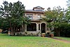 | October 13, 1988 (#87001737) | 405 W. Louisiana 33°11′47″N 96°36′28″W / 33.196389°N 96.607778°W / 33.196389; -96.607778 (Mrs. J. C. King House) | McKinney | Historic Resources of McKinney MPS |
| 45 | E. W. Kirkpatrick House and Barn |  | October 8, 1987 (#87001738) | 903 Parker 33°11′21″N 96°37′20″W / 33.189167°N 96.622222°W / 33.189167; -96.622222 (E. W. Kirkpatrick House and Barn) | McKinney | Recorded Texas Historic Landmark; Historic Resources of McKinney MPS |
| 46 | McKinney Commercial Historic District |  | January 10, 1983 (#83003132) | Roughly bounded by Herndon, Wood, Cloyd, Davis, Louisiana, MacDonald, and Virginia Sts. 33°11′51″N 96°36′51″W / 33.1975°N 96.614167°W / 33.1975; -96.614167 (McKinney Commercial Historic District) | McKinney | Includes State Antiquities Landmark, Recorded Texas Historic Landmarks |
| 47 | McKinney Cotton Compress Plant | 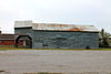 | June 27, 1988 (#87001739) | 300 blk. Throckmorton 33°12′01″N 96°36′22″W / 33.200278°N 96.606111°W / 33.200278; -96.606111 (McKinney Cotton Compress Plant) | McKinney | Historic Resources of McKinney MPS |
| 48 | McKinney Cotton Mill Historic District |  | October 8, 1987 (#87001740) | Roughly bounded by Elm, RR tracks, Burrus, Fowler, & Amscott 33°10′59″N 96°36′39″W / 33.183056°N 96.610833°W / 33.183056; -96.610833 (McKinney Cotton Mill Historic District) | McKinney | Historic Resources of McKinney MPS |
| 49 | Old McKinney Hospital |  | October 8, 1987 (#87001743) | 700-800 S. College 33°11′26″N 96°37′16″W / 33.190556°N 96.621111°W / 33.190556; -96.621111 (Old McKinney Hospital) | McKinney | Historic Resources of McKinney MPS |
| 50 | McKinney Residential Historic District |  | October 8, 1987 (#87001744) | Roughly bounded by W. Lamar, N. Benge, W. Louisiana, & N. Oak 33°11′56″N 96°37′15″W / 33.198889°N 96.620833°W / 33.198889; -96.620833 (McKinney Residential Historic District) | McKinney | Includes Recorded Texas Historic Landmarks; Historic Resources of McKinney MPS |
| 51 | Sam Neathery House |  | June 27, 1988 (#87001745) | 215 N. Waddill 33°11′56″N 96°37′36″W / 33.198889°N 96.626667°W / 33.198889; -96.626667 (Sam Neathery House) | McKinney | Historic Resources of McKinney MPS |
| 52 | J. P. Nenney House |  | June 27, 1988 (#87001746) | 601 N. Church 33°12′07″N 96°37′02″W / 33.201944°N 96.617222°W / 33.201944; -96.617222 (J. P. Nenney House) | McKinney | Historic Resources of McKinney MPS |
| 53 | R. F. Newsome House |  | October 8, 1987 (#87001747) | 609 Tucker 33°12′08″N 96°37′38″W / 33.202222°N 96.627222°W / 33.202222; -96.627222 (R. F. Newsome House) | McKinney | Historic Resources of McKinney MPS |
| 54 | Newsome-King House |  | October 8, 1987 (#87001748) | 401 W. Louisiana 33°11′48″N 96°36′27″W / 33.196667°N 96.6075°W / 33.196667; -96.6075 (Newsome-King House) | McKinney | Historic Resources of McKinney MPS |
| 55 | Plano Downtown Historic District |  | July 24, 2017 (#100001372) | 1000 blk. & 1112 E. 15th St., 1020 E. 15th Pl., 1410-1416 J & 1416-1430 K Aves., 33°01′11″N 96°42′00″W / 33.019845°N 96.699888°W / 33.019845; -96.699888 (Plano Downtown Historic District) | Plano | Includes Recorded Texas Historic Landmarks |
| 56 | Plano Station, Texas Electric Railway |  | August 10, 2005 (#05000856) | 901 E 15th St. 33°01′11″N 96°42′06″W / 33.019722°N 96.701667°W / 33.019722; -96.701667 (Plano Station, Texas Electric Railway) | Plano | Recorded Texas Historic Landmark; now Interurban Railway Museum |
| 57 | John C. Rhea House |  | June 27, 1988 (#87001749) | 801 N. College 33°12′14″N 96°37′15″W / 33.203889°N 96.620833°W / 33.203889; -96.620833 (John C. Rhea House) | McKinney | Recorded Texas Historic Landmark; Historic Resources of McKinney MPS |
| 58 | Saigling House | Upload image | May 14, 2018 (#100002434) | 902 E 16th St. 33°01′16″N 96°42′09″W / 33.021067°N 96.702484°W / 33.021067; -96.702484 (Saigling House) | Plano | |
| 59 | A. M. Scott House |  | October 8, 1987 (#87001750) | 1109 W. Louisiana 33°11′48″N 96°37′34″W / 33.196667°N 96.626111°W / 33.196667; -96.626111 (A. M. Scott House) | McKinney | Historic Resources of McKinney MPS |
| 60 | L. A. Scott House |  | June 27, 1988 (#87001751) | 513 W. Louisiana 33°11′48″N 96°37′15″W / 33.196667°N 96.620833°W / 33.196667; -96.620833 (L. A. Scott House) | McKinney | Historic Resources of McKinney MPS |
| 61 | Sister Grove Creek Site |  | August 22, 1977 (#77001432) | Address restricted[6] | Farmersville | |
| 62 | W. D. Smith House |  | October 8, 1987 (#87001752) | 703 N. College 33°12′11″N 96°37′15″W / 33.203056°N 96.620833°W / 33.203056; -96.620833 (W. D. Smith House) | McKinney | Historic Resources of McKinney MPS |
| 63 | J. H. Taylor House |  | October 8, 1987 (#87001753) | 211 N. Waddill 33°11′55″N 96°37′36″W / 33.198611°N 96.626667°W / 33.198611; -96.626667 (J. H. Taylor House) | McKinney | Historic Resources of McKinney MPS |
| 64 | Texas Pool | Upload image | April 1, 2019 (#100003598) | 901 Springbrook Dr. 33°00′44″N 96°43′19″W / 33.012288°N 96.721884°W / 33.012288; -96.721884 (Texas Pool) | Plano | |
| 65 | Thompson House |  | October 8, 1987 (#87001754) | 1207 W. Louisiana 33°11′48″N 96°37′37″W / 33.196667°N 96.626944°W / 33.196667; -96.626944 (Thompson House) | McKinney | Recorded Texas Historic Landmark; Historic Resources of McKinney MPS |
| 66 | R. L. Waddill House |  | October 8, 1987 (#87001755) | 302 W. Lamar 33°12′02″N 96°36′46″W / 33.200556°N 96.612778°W / 33.200556; -96.612778 (R. L. Waddill House) | McKinney | Historic Resources of McKinney MPS |
| 67 | Thomas W. Wiley House |  | October 8, 1987 (#87001756) | 105 S. Church 33°11′48″N 96°37′01″W / 33.196667°N 96.616944°W / 33.196667; -96.616944 (Thomas W. Wiley House) | McKinney | Historic Resources of McKinney MPS |
| 68 | A. G. Wilson House | 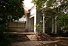 | October 8, 1987 (#87001757) | 417 N. Waddill 33°12′05″N 96°37′36″W / 33.201389°N 96.626667°W / 33.201389; -96.626667 (A. G. Wilson House) | McKinney | Historic Resources of McKinney MPS |
| 69 | Ammie Wilson House |  | December 28, 1978 (#78002906) | 1900 W. 15th St. 33°01′08″N 96°43′52″W / 33.018889°N 96.731111°W / 33.018889; -96.731111 (Ammie Wilson House) | Plano | Recorded Texas Historic Landmark |
Former listing
| [3] | Name on the Register | Image | Date listed | Date removed | Location | City or town | Description |
|---|---|---|---|---|---|---|---|
| 1 | Collin McKinney Cabin | Upload image | September 18, 1978 (#78002905) | April 14, 1981 | Finch Park | McKinney | Recorded Texas Historic Landmark. Destroyed by fire on December 10, 1980. |
See also
 National Register of Historic Places portal
 Texas portal


- National Register of Historic Places listings in Texas
- Recorded Texas Historic Landmarks in Collin County
References
- ^ National Park Service, United States Department of the Interior, "National Register of Historic Places: Weekly List Actions", retrieved April 12, 2024.
- ^ The latitude and longitude information provided in this table was derived originally from the National Register Information System, which has been found to be fairly accurate for about 99% of listings. Some locations in this table may have been corrected to current GPS standards.
- ^ a b Numbers represent an alphabetical ordering by significant words. Various colorings, defined here, differentiate National Historic Landmarks and historic districts from other NRHP buildings, structures, sites or objects.
- ^ "National Register Information System". National Register of Historic Places. National Park Service. July 9, 2010.
- ^ The eight-digit number below each date is the number assigned to each location in the National Register Information System database, which can be viewed by clicking the number.
- ^ Federal and state laws and practices restrict general public access to information regarding the specific location of this resource. In some cases, this is to protect archeological sites from vandalism, while in other cases it is restricted at the request of the owner. See: Knoerl, John; Miller, Diane; Shrimpton, Rebecca H. (1990), Guidelines for Restricting Information about Historic and Prehistoric Resources, National Register Bulletin, National Park Service, U.S. Department of the Interior, OCLC 20706997.
External links
![]() Media related to National Register of Historic Places in Collin County, Texas at Wikimedia Commons
Media related to National Register of Historic Places in Collin County, Texas at Wikimedia Commons
- v
- t
- e
by county
- Anderson
- Andrews
- Angelina
- Aransas
- Archer
- Armstrong
- Atascosa
- Austin
- Bailey
- Bandera
- Bastrop
- Baylor
- Bee
- Bell
- Bexar
- Blanco
- Borden
- Bosque
- Bowie
- Brazoria
- Brazos
- Brewster
- Briscoe
- Brooks
- Brown
- Burleson
- Burnet
- Caldwell
- Calhoun
- Callahan
- Cameron
- Camp
- Carson
- Cass
- Castro
- Chambers
- Cherokee
- Childress
- Clay
- Cochran
- Coke
- Coleman
- Collin
- Collingsworth
- Colorado
- Comal
- Comanche
- Concho
- Cooke
- Coryell
- Cottle
- Crane
- Crockett
- Crosby
- Culberson
- Dallam
- Dallas
- Dawson
- Deaf Smith
- Delta
- Denton
- DeWitt
- Dickens
- Dimmit
- Donley
- Duval
- Eastland
- Ector
- Edwards
- El Paso
- Ellis
- Erath
- Falls
- Fannin
- Fayette
- Fisher
- Floyd
- Foard
- Fort Bend
- Franklin
- Freestone
- Frio
- Gaines
- Galveston
- Garza
- Gillespie
- Glasscock
- Goliad
- Gonzales
- Gray
- Grayson
- Gregg
- Grimes
- Guadalupe
- Hale
- Hall
- Hamilton
- Hansford
- Hardeman
- Hardin
- Harris
- Harrison
- Hartley
- Haskell
- Hays
- Hemphill
- Henderson
- Hidalgo
- Hill
- Hockley
- Hood
- Hopkins
- Houston
- Howard
- Hudspeth
- Hunt
- Hutchinson
- Irion
- Jack
- Jackson
- Jasper
- Jeff Davis
- Jefferson
- Jim Hogg
- Jim Wells
- Johnson
- Jones
- Karnes
- Kaufman
- Kendall
- Kenedy
- Kent
- Kerr
- Kimble
- King
- Kinney
- Kleberg
- Knox
- La Salle
- Lamar
- Lamb
- Lampasas
- Lavaca
- Lee
- Leon
- Liberty
- Limestone
- Lipscomb
- Live Oak
- Llano
- Loving
- Lubbock
- Lynn
- Madison
- Marion
- Martin
- Mason
- Matagorda
- Maverick
- McCulloch
- McLennan
- McMullen
- Medina
- Menard
- Midland
- Milam
- Mills
- Mitchell
- Montague
- Montgomery
- Moore
- Morris
- Motley
- Nacogdoches
- Navarro
- Newton
- Nolan
- Nueces
- Ochiltree
- Oldham
- Orange
- Palo Pinto
- Panola
- Parker
- Parmer
- Pecos
- Polk
- Potter
- Presidio
- Rains
- Randall
- Reagan
- Real
- Red River
- Reeves
- Refugio
- Roberts
- Robertson
- Rockwall
- Runnels
- Rusk
- Sabine
- San Augustine
- San Jacinto
- San Patricio
- San Saba
- Schleicher
- Scurry
- Shackelford
- Shelby
- Sherman
- Smith
- Somervell
- Starr
- Stephens
- Sterling
- Stonewall
- Sutton
- Swisher
- Tarrant
- Taylor
- Terrell
- Terry
- Throckmorton
- Titus
- Tom Green
- Travis
- Trinity
- Tyler
- Upshur
- Upton
- Uvalde
- Val Verde
- Van Zandt
- Victoria
- Walker
- Waller
- Ward
- Washington
- Webb
- Wharton
- Wheeler
- Wichita
- Wilbarger
- Willacy
- Williamson
- Wilson
- Winkler
- Wise
- Wood
- Yoakum
- Young
- Zapata
- Zavala

Municipalities and communities of Collin County, Texas, United States | ||
|---|---|---|
County seat: McKinney | ||
| Cities |  | |
| Towns | ||
| CDPs | ||
| Other communities |
| |
| Historical communities | ||
| Ghost towns | ||
| Footnotes | ‡This populated place also has portions in an adjacent county or counties | |
| ||


