National Register of Historic Places listings in Humboldt County, California
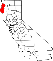
This is a list of the National Register of Historic Places listings in Humboldt County, California.
This is intended to be a complete list of the properties and districts on the National Register of Historic Places in Humboldt County, California, United States. Latitude and longitude coordinates are provided for many National Register properties and districts; these locations may be seen together in an online map.[1]
There are 57 properties and districts listed on the National Register in the county, including 1 National Historic Landmark.
This National Park Service list is complete through NPS recent listings posted April 26, 2024.[2]
Map all coordinates using OpenStreetMap
Download coordinates as:
- KML
- GPX (all coordinates)
- GPX (primary coordinates)
- GPX (secondary coordinates)
Current listings
| [3] | Name on the Register[4] | Image | Date listed[5] | Location | City or town | Description |
|---|---|---|---|---|---|---|
| 1 | Alford-Nielson House |  | January 23, 1986 (#86000100) | 1299 Main St. 40°35′09″N 124°15′29″W / 40.585833°N 124.258056°W / 40.585833; -124.258056 (Alford-Nielson House) | Ferndale | 1874 French Second Empire, moved from 421 to 1299 Main Street in 1893 |
| 2 | F. W. Andreasen-John Rossen House |  | September 25, 1989 (#89000855) | Port Kenyon Rd. and Bush St. 40°35′38″N 124°16′21″W / 40.593889°N 124.2725°W / 40.593889; -124.2725 (F. W. Andreasen-John Rossen House) | Ferndale | 1901 Queen Anne, William S. Fitzell (architect) |
| 3 | Bald Hills Archaeological District | Upload image | July 9, 1982 (#82001723) | Address Restricted | Orick | c. 500 B.C. to 1000 A.D. Chilula cultural site |
| 4 | Bank of Eureka Building |  | April 12, 1982 (#82002180) | 240 E St. 40°48′13″N 124°09′59″W / 40.803611°N 124.166389°W / 40.803611; -124.166389 (Bank of Eureka Building) | Eureka | 1911, Classic Revival, now Clarke Memorial Museum |
| 5 | Bank of Loleta |  | February 28, 1985 (#85000354) | 358 Main St. 40°38′26″N 124°13′26″W / 40.640556°N 124.223889°W / 40.640556; -124.223889 (Bank of Loleta) | Loleta | 1920 Classical Revival commercial building (1985 NRHP plaque) |
| 6 | Benbow Inn | 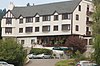 | September 15, 1983 (#83001179) | 445 Lake Benbow Dr. 40°04′04″N 123°47′19″W / 40.067778°N 123.788611°W / 40.067778; -123.788611 (Benbow Inn) | Garberville | 1925 Tudor Revival Hotel |
| 7 | A. Berding House |  | January 4, 1983 (#83001180) | 455 Ocean Ave. 40°34′33″N 124°15′46″W / 40.575833°N 124.262778°W / 40.575833; -124.262778 (A. Berding House) | Ferndale | 1875, also called "The Gum Drop Tree House" for the row of trimmed Cypress trees in front |
| 8 | Carlotta Hotel | Upload image | May 23, 1978 (#78000671) | Central Ave. 40°32′17″N 124°03′30″W / 40.538056°N 124.058333°W / 40.538056; -124.058333 (Carlotta Hotel) | Carlotta | Built in 1904, burned down in 1995 |
| 9 | Carnegie Free Library |  | January 23, 1986 (#86000101) | 636 F St. 40°48′02″N 124°09′52″W / 40.800556°N 124.164444°W / 40.800556; -124.164444 (Carnegie Free Library) | Eureka | 1903, currently Morris Graves Museum of Art |
| 10 | John G. Chapman House |  | September 29, 2011 (#11000713) | 974 10th St. 40°52′14″N 124°05′18″W / 40.870556°N 124.088333°W / 40.870556; -124.088333 (John G. Chapman House) | Arcata | |
| 11 | William S. Clark House |  | January 14, 1988 (#87002394) | 1406 C St. 40°47′39″N 124°10′03″W / 40.794167°N 124.1675°W / 40.794167; -124.1675 (William S. Clark House) | Eureka | 1888, 1.5 story Eastlake Residential |
| 12 | John A. Cottrell House |  | September 28, 2005 (#05001084) | 1228 C St. 40°47′43″N 124°10′04″W / 40.795278°N 124.167778°W / 40.795278; -124.167778 (John A. Cottrell House) | Eureka | c.1900, 2 Story Queen Anne/Eastlake Residence |
| 13 | De-No-To Cultural District | Upload image | April 24, 1985 (#85000901) | Address Restricted | Hoopa | Hupa, Karuk cultural site |
| 14 | Eureka Historic District | 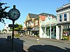 | October 15, 1991 (#91001523) | Roughly, First, Second and Third Sts., between C and N Sts. 40°48′17″N 124°09′47″W / 40.804722°N 124.163056°W / 40.804722; -124.163056 (Eureka Historic District) | Eureka | 11 block long, three block wide district of Late Victorian, Greek Revival, Classical Revival storefronts & residences. Includes the E. Janssen Building and the Bank of Eureka Building |
| 15 | Eureka Inn | 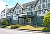 | February 11, 1982 (#82002181) | 7th and F Sts. 40°48′00″N 124°09′49″W / 40.8°N 124.163611°W / 40.8; -124.163611 (Eureka Inn) | Eureka | 1900 Tudor Revival Hotel |
| 16 | Eureka Theatre |  | January 7, 2010 (#09001199) | 612 F St. 40°48′03″N 124°09′58″W / 40.800733°N 124.166217°W / 40.800733; -124.166217 (Eureka Theatre) | Eureka | 1937 Streamline Moderne Theater |
| 17 | Falk Archaeological District | Upload image | November 6, 2023 (#100009504) | Address Restricted | Eureka | |
| 18 | Fern Cottage Historic District |  | January 7, 1988 (#87002294) | 2121 Centerville Road 40°35′04″N 124°18′32″W / 40.584444°N 124.308889°W / 40.584444; -124.308889 (Fern Cottage Historic District) | Ferndale | 160 acre historic district: 16 buildings and 2 structures contribute to listing including historic Fern Cottage, home of the Russ pioneer family. |
| 19 | Fernbridge |  | April 2, 1987 (#87000566) | CA 211 40°36′51″N 124°12′08″W / 40.614167°N 124.202222°W / 40.614167; -124.202222 (Fernbridge) | Fernbridge | 1,320 feet (400 m) concrete arch built 1911, John B. Leonard (engineer) http://ca.water.usgs.gov/webcams/fernbridge/ |
| 20 | Ferndale Main Street Historic District |  | January 10, 1994 (#93001461) | 300–580 Main, 330 Ocean Avenue and 207–290 Francis Street 40°34′35″N 124°15′45″W / 40.576389°N 124.2625°W / 40.576389; -124.2625 (Ferndale Main Street Historic District) | Ferndale | 5 block long Italianate, Stick/Eastlake, Queen Anne commercial and mixed use buildings |
| 21 | Ferndale Public Library | 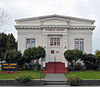 | December 10, 1990 (#90001815) | 807 Main St. 40°34′47″N 124°15′36″W / 40.579722°N 124.26°W / 40.579722; -124.26 (Ferndale Public Library) | Ferndale | 1910 Classical Revival Carnegie Library, Warren Skellings (architect) http://www.carnegie-libraries.org/california/ferndale.html |
| 22 | First and F Street Building |  | July 12, 1974 (#74000511) | 112 F St. 40°48′19″N 124°09′57″W / 40.805278°N 124.165833°W / 40.805278; -124.165833 (First and F Street Building) | Eureka | 1893, commercial corner Stick/Eastlake |
| 23 | Grizzly Bluff School |  | November 27, 1979 (#79000476) | East of Ferndale on Grizzly Bluff Road 40°33′46″N 124°10′12″W / 40.562778°N 124.17°W / 40.562778; -124.17 (Grizzly Bluff School) | Ferndale | 1871 Greek Revival School House |
| 24 | Gunther Island Site 67 |  | 15 October 1966 (#66000208) | Humboldt Bay 40°48′47″N 124°10′06″W / 40.812997°N 124.168389°W / 40.812997; -124.168389 (Gunther Island Site 67) | Eureka | location of the 1860 Wiyot Massacre |
| 25 | Gushaw-Mudgett House |  | January 11, 1982 (#82002184) | 820 9th St. 40°35′57″N 124°09′28″W / 40.599059°N 124.157744°W / 40.599059; -124.157744 (Gushaw-Mudgett House) | Fortuna | 1884, Italianate, Stick/Eastlake residence |
| 26 | Holy Trinity Church |  | August 6, 1980 (#80004608) | Parker and Hector St. 41°03′33″N 124°08′29″W / 41.05908°N 124.141442°W / 41.05908; -124.141442 (Holy Trinity Church) | Trinidad | 1850 |
| 27 | Hoopa Valley Adobe |  | January 7, 2013 (#10000893) | Campus Street 41°02′51″N 123°40′43″W / 41.047633°N 123.678591°W / 41.047633; -123.678591 (Hoopa Valley Adobe) | Hoopa | |
| 28 | Hotel Arcata |  | January 5, 1984 (#84000775) | 708 9th St. 40°52′09″N 124°05′05″W / 40.869167°N 124.084722°W / 40.869167; -124.084722 (Hotel Arcata) | Arcata | 1900 Hotel |
| 29 | Humboldt Bay Life-Saving Station | 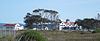 | October 30, 1979 (#79000477) | South of Samoa on Samoa Rd 40°46′05″N 124°13′05″W / 40.768056°N 124.218056°W / 40.768056; -124.218056 (Humboldt Bay Life-Saving Station) | Samoa | 1875/1936, Coast Guard Building |
| 30 | Humboldt Bay Woolen Mill |  | June 25, 1982 (#82002182) | 1400 Broadway 40°47′38″N 124°10′35″W / 40.793889°N 124.176389°W / 40.793889; -124.176389 (Humboldt Bay Woolen Mill) | Eureka | 1901, 2 story frame industrial with 1920s add-ons was demolished in 1987. Second from left on bottom row, #21 on original map. |
| 31 | Jacoby Building |  | June 17, 1982 (#82002179) | 791 8th St. 40°52′06″N 124°05′10″W / 40.868333°N 124.086111°W / 40.868333; -124.086111 (Jacoby Building) | Arcata | 1850, Four Story Renaissance, Classical Revival built for storehouse and shops |
| 32 | E. Janssen Building |  | July 16, 1973 (#73000402) | 422 First St. 40°48′18″N 124°09′59″W / 40.805°N 124.166389°W / 40.805; -124.166389 (E. Janssen Building) | Eureka | 1875, 2 story cast-iron fronted Italianate loft commercial building built for general merchandise and groceries |
| 33 | James Kleiser House | Upload image | January 30, 2023 (#100008586) | 1022 10th St. 40°52′13″N 124°05′20″W / 40.8704°N 124.0889°W / 40.8704; -124.0889 (James Kleiser House) | Arcata | |
| 34 | Lower Blackburn Grade Bridge | 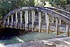 | June 25, 1981 (#81000148) | Northwest of Bridgeville on CA 36 40°28′50″N 123°53′22″W / 40.480556°N 123.889444°W / 40.480556; -123.889444 (Lower Blackburn Grade Bridge) | Bridgeville | 1925 |
| 35 | Lyons Ranches Historic District | Upload image | March 19, 2018 (#100002212) | Bald Hills Road, Redwoods National Park 41°08′53″N 123°53′36″W / 41.148130°N 123.893215°W / 41.148130; -123.893215 (Lyons Ranches Historic District) | Orick vicinity | |
| 36 | D. C. McDonald Building | | November 17, 1982 (#82000966) | 108 F Street 40°48′18″N 124°09′57″W / 40.805°N 124.165833°W / 40.805; -124.165833 (D. C. McDonald Building) | Eureka | 1904, 2 Story, Classical Revival, at left end of historic row in photo. |
| 37 | George McFarlan House |  | November 15, 1978 (#78000672) | 1410 2nd St. 40°48′22″N 124°09′20″W / 40.806111°N 124.155556°W / 40.806111; -124.155556 (George McFarlan House) | Eureka | ca. 1857, Greek Revival, possibly a kit house or reassembled on site as parts are numbered |
| 38 | Odd Fellows Hall |  | May 3, 1978 (#78000673) | 123 F St. 40°48′17″N 124°10′00″W / 40.804661°N 124.166701°W / 40.804661; -124.166701 (Odd Fellows Hall) | Eureka | 1882, 2 Story Second Empire |
| 39 | Old Jacoby Creek School | 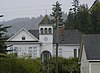 | February 28, 1985 (#85000353) | 2212 Jacoby Creek Rd. 40°50′34″N 124°03′43″W / 40.842778°N 124.061944°W / 40.842778; -124.061944 (Old Jacoby Creek School) | Bayside | 1900 |
| 40 | Phillips House |  | October 24, 1985 (#85003373) | 71 East Seventh Street 40°51′58″N 124°04′37″W / 40.866111°N 124.076944°W / 40.866111; -124.076944 (Phillips House) | Arcata | 1850, Greek Revival |
| 41 | Prairie Creek Fish Hatchery |  | February 4, 2000 (#00000034) | Milepost 124.83 on US 101, north of Orick 41°19′59″N 124°01′45″W / 41.333056°N 124.029167°W / 41.333056; -124.029167 (Prairie Creek Fish Hatchery) | Orick | In use 1925 to 1949. |
| 42 | Punta Gorda Light Station |  | September 1, 1976 (#76000483) | 10.5 miles (16.9 km) southwest of Petrolia 40°14′58″N 124°20′44″W / 40.249444°N 124.345556°W / 40.249444; -124.345556 (Punta Gorda Light Station) | Petrolia | 1900 Light House |
| 43 | Pythian Castle | 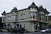 | February 20, 1986 (#86000263) | 1100 H St. 40°52′16″N 124°05′06″W / 40.871111°N 124.085°W / 40.871111; -124.085 (Pythian Castle) | Arcata | 1875, 2 story Queen Anne Knights of Pythias meeting hall |
| 44 | Rectory, Catholic Church of the Assumption | 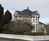 | February 11, 1982 (#82002183) | 563 Ocean Avenue 40°34′30″N 124°15′42″W / 40.575°N 124.261667°W / 40.575; -124.261667 (Rectory, Catholic Church of the Assumption) | Ferndale | 1875 Queen Anne, Stick/Eastlake, George F. Costerisa, builder/architect |
| 45 | Thomas F. Ricks House | 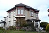 | October 2, 1992 (#92001302) | 730 H Street 40°48′00″N 124°09′45″W / 40.8°N 124.1625°W / 40.8; -124.1625 (Thomas F. Ricks House) | Eureka | c.1885, 2 story Eastlake, portico and double 2 story bays |
| 46 | Schorlig House | 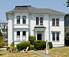 | November 20, 1978 (#78000670) | 1050 12th Street 40°52′21″N 124°05′14″W / 40.8725°N 124.087222°W / 40.8725; -124.087222 (Schorlig House) | Arcata | 1875 residence |
| 47 | Shaw House |  | September 13, 1984 (#84000777) | 703 Main Street 40°34′45″N 124°15′39″W / 40.579167°N 124.260833°W / 40.579167; -124.260833 (Shaw House) | Ferndale | 1866 Carpenter Gothic, served as post office and courthouse |
| 48 | Simpson-Vance House |  | July 17, 1986 (#86001668) | 904 G Street 40°47′55″N 124°09′47″W / 40.798611°N 124.163056°W / 40.798611; -124.163056 (Simpson-Vance House) | Eureka | 1892, 2 Story Queen Anne, polygonal corner tower |
| 49 | Stone House |  | February 27, 1986 (#86000267) | 902 14th Street 40°52′25″N 124°05′11″W / 40.8735°N 124.0864°W / 40.8735; -124.0864 (Stone House) | Arcata | 1875, Queen Anne |
| 50 | Sweasey Theater-Loew's State Theater |  | June 5, 2009 (#09000372) | 412 G St. 40°48′10″N 124°09′54″W / 40.802797°N 124.165131°W / 40.802797; -124.165131 (Sweasey Theater-Loew's State Theater) | Eureka | 1919 theater with terracotta facade |
| 51 | Tishawnik | Upload image | January 21, 2015 (#12000397) | Address Restricted | Orleans | |
| 52 | Trinidad Head Light Station |  | September 3, 1991 (#91001098) | Trinidad Head 41°03′14″N 124°08′55″W / 41.053889°N 124.148611°W / 41.053889; -124.148611 (Trinidad Head Light Station) | Trinidad | 1871, light elevation of 196 feet, bluff-mounted lighthouse elevation 20 feet |
| 53 | Tsahpek | Upload image | December 5, 1972 (#72000224) | Address Restricted | Eureka | Yurok village, also known as Tsah Pek |
| 54 | U.S. Post Office and Courthouse | 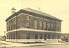 | February 10, 1983 (#83001181) | 514 H Street 40°48′07″N 124°09′47″W / 40.801944°N 124.163056°W / 40.801944; -124.163056 (U.S. Post Office and Courthouse) | Eureka | 1909, 3 Story Renaissance Revival |
| 55 | Washington School | 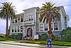 | April 12, 2002 (#02000329) | 1910 California Street 40°47′27″N 124°10′16″W / 40.790833°N 124.171111°W / 40.790833; -124.171111 (Washington School) | Eureka | 2 story school house |
| 56 | Whaley House |  | December 31, 1979 (#79000475) | 1395 H Street 40°52′23″N 124°05′03″W / 40.873056°N 124.084167°W / 40.873056; -124.084167 (Whaley House) | Arcata | 1850 Greek Revival |
| 57 | Magdalena Zanone House |  | April 21, 2004 (#04000335) | 1604 G Street 40°47′35″N 124°09′47″W / 40.792972°N 124.163°W / 40.792972; -124.163 (Magdalena Zanone House) | Eureka | c.1908, 2 story Queen Anne with tower |
See also
Wikimedia Commons has media related to National Register of Historic Places in Humboldt County, California.
- List of National Historic Landmarks in California
- National Register of Historic Places listings in California
- California Historical Landmarks in Humboldt County, California
References
- ^ The latitude and longitude information provided in this table was derived originally from the National Register Information System, which has been found to be fairly accurate for about 99% of listings. Some locations in this table may have been corrected to current GPS standards.
- ^ National Park Service, United States Department of the Interior, "National Register of Historic Places: Weekly List Actions", retrieved April 26, 2024.
- ^ Numbers represent an alphabetical ordering by significant words. Various colorings, defined here, differentiate National Historic Landmarks and historic districts from other NRHP buildings, structures, sites or objects.
- ^ "National Register Information System". National Register of Historic Places. National Park Service. July 9, 2010.
- ^ The eight-digit number below each date is the number assigned to each location in the National Register Information System database, which can be viewed by clicking the number.
- v
- t
- e
- List of U.S. National Historic Landmarks by state:
- Alabama
- Alaska
- Arizona
- Arkansas
- California
- Colorado
- Connecticut
- Delaware
- Florida
- Georgia
- Hawaii
- Idaho
- Illinois
- Indiana
- Iowa
- Kansas
- Kentucky
- Louisiana
- Maine
- Maryland
- Massachusetts
- Michigan
- Minnesota
- Mississippi
- Missouri
- Montana
- Nebraska
- Nevada
- New Hampshire
- New Jersey
- New Mexico
- New York
- North Carolina
- North Dakota
- Ohio
- Oklahoma
- Oregon
- Pennsylvania
- Rhode Island
- South Carolina
- South Dakota
- Tennessee
- Texas
- Utah
- Vermont
- Virginia
- Washington
- West Virginia
- Wisconsin
- Wyoming
 National Register of Historic Places portal
 Category


