National Register of Historic Places listings in Idaho County, Idaho

This is a list of the National Register of Historic Places listings in Idaho County, Idaho.
This is intended to be a complete list of the properties and districts on the National Register of Historic Places in Idaho County, Idaho, United States. Latitude and longitude coordinates are provided for many National Register properties and districts; these locations may be seen together in a map.[1]
There are 43 properties and districts listed on the National Register in the county.
Map all coordinates using OpenStreetMap
Download coordinates as:
- KML
- GPX (all coordinates)
- GPX (primary coordinates)
- GPX (secondary coordinates)
This National Park Service list is complete through NPS recent listings posted September 13, 2024.[2]
Current listings
| [3] | Name on the Register[4] | Image | Date listed[5] | Location | City or town | Description |
|---|---|---|---|---|---|---|
| 1 | Ah Toy Garden | Upload image | June 27, 1990 (#90000893) | Along China Creek near its confluence with the South Fork of the Salmon River in the Payette National Forest 45°12′57″N 115°33′21″W / 45.215833°N 115.555833°W / 45.215833; -115.555833 (Ah Toy Garden) | Warren | |
| 2 | Aitken Barn |  | August 9, 1982 (#82002512) | Southwest of Riggins on U.S. Route 95 45°24′28″N 116°19′48″W / 45.407896°N 116.329933°W / 45.407896; -116.329933 (Aitken Barn) | Riggins | |
| 3 | Arctic Point Fire Lookout |  | August 29, 1994 (#94001019) | North of Big Creek in the Frank Church-River of No Return Wilderness and the Payette National Forest 45°28′28″N 115°02′19″W / 45.474373°N 115.038593°W / 45.474373; -115.038593 (Arctic Point Fire Lookout) | Big Creek | |
| 4 | James V. and Sophia Baker House | 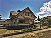 | January 6, 2004 (#03001366) | 204 Broadway St. 46°02′51″N 116°21′04″W / 46.047448°N 116.351135°W / 46.047448; -116.351135 (James V. and Sophia Baker House) | Cottonwood | |
| 5 | Polly Bemis House |  | March 4, 1988 (#87002152) | Accessible on the Salmon River via boat 45°25′59″N 115°40′13″W / 45.433056°N 115.670278°W / 45.433056; -115.670278 (Polly Bemis House) | Riggins | |
| 6 | Big Cedar School |  | November 29, 2016 (#16000806) | 947 Red Fir Rd. 46°05′52″N 115°51′08″W / 46.097790°N 115.852185°W / 46.097790; -115.852185 (Big Cedar School) | Kooskia | |
| 7 | Blue Fox Theatre | 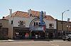 | November 30, 1999 (#99001412) | 116 W. Main St. 45°55′32″N 116°07′09″W / 45.925556°N 116.119167°W / 45.925556; -116.119167 (Blue Fox Theatre) | Grangeville | |
| 8 | Burgdorf |  | April 14, 1972 (#72000441) | About 15 miles west of Warrens 45°16′38″N 115°54′46″W / 45.277222°N 115.912778°W / 45.277222; -115.912778 (Burgdorf) | Burgdorf | |
| 9 | Butts Point Creek Fire Lookout | Upload image | December 28, 2018 (#100002786) | Butts Creek Point, approx.. 40 mi. NE of Salmon, ID; Frank Church – River of No Return Wilderness 45°21′42″N 114°44′15″W / 45.3616°N 114.7374°W / 45.3616; -114.7374 (Butts Point Creek Fire Lookout) | Salmon vicinity | |
| 10 | Campbell's Ferry | Upload image | February 8, 2007 (#07000037) | Southeastern bank of the Salmon River at Mile 148 in the Frank Church-River of No Return Wilderness 45°29′11″N 115°20′03″W / 45.486252°N 115.334133°W / 45.486252; -115.334133 (Campbell's Ferry) | Riggins | |
| 11 | Carey Dome Fire Lookout | Upload image | March 25, 1994 (#94000268) | Nez Perce National Forest, 9 miles north of United States Forest Service Burgdorf Guard Station 45°24′10″N 115°54′12″W / 45.402778°N 115.903333°W / 45.402778; -115.903333 (Carey Dome Fire Lookout) | Burgdorf | |
| 12 | Celadon Slope Garden | Upload image | June 27, 1990 (#90000891) | Along China Creek near its confluence with the South Fork of the Salmon River in the Payette National Forest 45°12′58″N 115°34′15″W / 45.216111°N 115.570833°W / 45.216111; -115.570833 (Celadon Slope Garden) | Warren | |
| 13 | Chamberlain Ranger Station Historic District | Upload image | January 14, 2004 (#03001388) | Frank Church-River of No Return Wilderness 45°22′32″N 115°12′02″W / 45.375556°N 115.200556°W / 45.375556; -115.200556 (Chamberlain Ranger Station Historic District) | Payette National Forest | |
| 14 | Chi-Sandra Garden | Upload image | June 27, 1990 (#90000892) | Along China Creek near its confluence with the South Fork of the Salmon River in the Payette National Forest 45°12′52″N 115°33′50″W / 45.214444°N 115.563889°W / 45.214444; -115.563889 (Chi-Sandra Garden) | Warren | |
| 15 | Chinese Cemetery | Upload image | March 29, 1994 (#94000270) | Payette National Forest, 0.5 miles northwest of Warren Wagon Rd. at B 45°16′22″N 115°41′06″W / 45.272778°N 115.685°W / 45.272778; -115.685 (Chinese Cemetery) | Warren | |
| 16 | Chinese Mining Camp Archeological Site | Upload image | September 4, 1994 (#94001018) | Northwest of Warren in the Payette National Forest 45°16′14″N 115°41′34″W / 45.270556°N 115.692778°W / 45.270556; -115.692778 (Chinese Mining Camp Archeological Site) | Warren | |
| 17 | Cold Meadows Guard Station | Upload image | August 19, 1994 (#94001017) | Northeast of McCall in the Frank Church-River of No Return Wilderness and the Payette National Forest 45°17′10″N 114°56′28″W / 45.286111°N 114.941111°W / 45.286111; -114.941111 (Cold Meadows Guard Station) | McCall | |
| 18 | Deep Creek Ranger Station | Upload image | December 11, 2013 (#13000902) | West Fork Ranger District, Bitterroot National Forest 45°42′15″N 114°43′03″W / 45.704052°N 114.717392°W / 45.704052; -114.717392 (Deep Creek Ranger Station) | Bitterroot National Forest | |
| 19 | Jurden Henry Elfers Barn and Field |  | June 7, 2007 (#07000544) | South bank of John Day Creek, ⅓ mile east of U.S. Route 95 45°34′59″N 116°17′15″W / 45.582957°N 116.287626°W / 45.582957; -116.287626 (Jurden Henry Elfers Barn and Field) | Lucile | |
| 20 | Elk City Wagon Road-Vicory Gulch-Smith Grade Segment | Upload image | May 21, 2001 (#01000536) | Nez Perce National Forest 45°51′29″N 115°35′23″W / 45.858056°N 115.589722°W / 45.858056; -115.589722 (Elk City Wagon Road-Vicory Gulch-Smith Grade Segment) | Elk City | Surviving segment of historic wagon road to mining town of Elk City. |
| 21 | Fenn Ranger Station |  | June 18, 1990 (#90000931) | Selway Road 223 near Johnson Creek in the Nez Perce National Forest 46°06′06″N 115°32′41″W / 46.101667°N 115.544722°W / 46.101667; -115.544722 (Fenn Ranger Station) | Kooskia | |
| 22 | First Presbyterian Church |  | May 13, 1976 (#76000674) | Southeast of Kamiah on U.S. Route 12 46°12′15″N 116°00′24″W / 46.204286°N 116.006639°W / 46.204286; -116.006639 (First Presbyterian Church) | Kamiah | |
| 23 | Dr. Wilson Foskett Home and Drugstore |  | April 26, 2005 (#05000337) | West side of River Rd. 45°45′44″N 116°18′01″W / 45.762222°N 116.300278°W / 45.762222; -116.300278 (Dr. Wilson Foskett Home and Drugstore) | White Bird | |
| 24 | Blacky Foster House | Upload image | April 10, 1992 (#92000307) | Along the Salmon River west of Shoup in the Bitterroot National Forest 45°29′10″N 114°58′29″W / 45.486111°N 114.974722°W / 45.486111; -114.974722 (Blacky Foster House) | Shoup | |
| 25 | Gardiner Peak Lookout |  | April 6, 2018 (#100002295) | Gardiner Peak, West Fork District 45°58′12″N 114°46′00″W / 45.969959°N 114.766586°W / 45.969959; -114.766586 (Gardiner Peak Lookout) | Bitterroot National Forest | |
| 26 | Gold Point Mill |  | July 14, 2000 (#00000792) | United States Forest Service Road 222 45°46′56″N 115°23′33″W / 45.782222°N 115.3925°W / 45.782222; -115.3925 (Gold Point Mill) | Elk City | |
| 27 | Hells Canyon Archeological District | 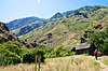 | August 10, 1984 (#84000984) | Address Restricted[6] | Riggins | Extends into Adams and Nez Perce counties and Wallowa County, Oregon |
| 28 | Lochsa Historical Ranger Station |  | June 9, 1978 (#78001065) | Lewis and Clark Highway (U.S. Route 12) 46°20′20″N 115°19′45″W / 46.338790°N 115.329096°W / 46.338790; -115.329096 (Lochsa Historical Ranger Station) | Kooskia | Open as a museum |
| 29 | Lower Salmon River Archeological District |  | September 4, 1986 (#86002170) | Address Restricted[6] | Cottonwood | Extends into Lewis and Nez Perce counties |
| 30 | Sue McBeth Cabin |  | June 3, 1976 (#76000675) | Southeast of Kamiah on U.S. Route 12 46°12′18″N 116°00′22″W / 46.205°N 116.006111°W / 46.205; -116.006111 (Sue McBeth Cabin) | Kamiah | |
| 31 | Meinert Ranch Cabin | Upload image | September 23, 1987 (#87001561) | 1.8 miles southwest of Red River Hot Springs on Red River-Beargrass Road 234 45°46′19″N 115°13′22″W / 45.771944°N 115.222778°W / 45.771944; -115.222778 (Meinert Ranch Cabin) | Elk City | |
| 32 | Jim Moore Place | Upload image | March 29, 1978 (#78001063) | Salmon River Canyon 45°29′13″N 115°20′14″W / 45.486944°N 115.337222°W / 45.486944; -115.337222 (Jim Moore Place) | Dixie | |
| 33 | Moose Creek Administrative Site | Upload image | June 25, 1990 (#90000932) | Eastern side of Moose Creek, south of Whistling Pig Creek, in the Nez Perce National Forest 46°06′40″N 114°55′15″W / 46.111111°N 114.920833°W / 46.111111; -114.920833 (Moose Creek Administrative Site) | Grangeville | |
| 34 | Old China Trail | Upload image | June 27, 1990 (#90000894) | Along China Creek near its confluence with the South Fork of the Salmon River in the Payette National Forest 45°13′00″N 115°33′48″W / 45.216667°N 115.563333°W / 45.216667; -115.563333 (Old China Trail) | Warren | |
| 35 | Riggins Motel |  | September 14, 2001 (#01000979) | 615 S. State Highway 95 45°25′05″N 116°19′02″W / 45.418056°N 116.317222°W / 45.418056; -116.317222 (Riggins Motel) | Riggins | |
| 36 | St. Gertrude's Convent and Chapel |  | June 18, 1979 (#79000790) | West of Cottonwood 46°02′01″N 116°23′25″W / 46.033611°N 116.390278°W / 46.033611; -116.390278 (St. Gertrude's Convent and Chapel) | Cottonwood | |
| 37 | Salmon Mountain Lookout | Upload image | April 6, 2018 (#100002296) | Salmon Mtn., West Fork District 45°37′01″N 114°50′12″W / 45.616925°N 114.836789°W / 45.616925; -114.836789 (Salmon Mountain Lookout) | Bitterroot National Forest | |
| 38 | State Bank of Kooskia |  | May 22, 1978 (#78001067) | 1 S. Main St. 46°08′24″N 115°58′40″W / 46.14°N 115.977778°W / 46.14; -115.977778 (State Bank of Kooskia) | Kooskia | |
| 39 | Tolo Lake |  | February 7, 2011 (#10001200) | Tolo Lake Rd., Nez Perce National Historical Park 45°54′54″N 116°14′10″W / 45.915°N 116.236111°W / 45.915; -116.236111 (Tolo Lake) | Grangeville | Tolo Lake page on NPS website |
| 40 | Warren Guard Station, Building 1206 | Upload image | April 7, 1994 (#94000271) | Southwestern side of Warren Wagon Rd., United States Forest Service Highway 21 45°16′02″N 115°40′16″W / 45.267222°N 115.671111°W / 45.267222; -115.671111 (Warren Guard Station, Building 1206) | Warren | |
| 41 | White Bird Battlefield |  | July 18, 1974 (#74000332) | North of White Bird off U.S. Route 95 45°47′30″N 116°16′47″W / 45.791667°N 116.279722°W / 45.791667; -116.279722 (White Bird Battlefield) | White Bird | |
| 42 | White Bird Grade |  | July 30, 1974 (#74000740) | Northeast of White Bird 45°48′58″N 116°15′11″W / 45.816076°N 116.253084°W / 45.816076; -116.253084 (White Bird Grade) | White Bird | Switchbacks and winding roadway of Old Highway 95, formerly U.S. Highway 95, an engineering feat when built in 1920 as part of "good roads" movement. |
| 43 | Yawwinma Traditional Cultural Property |  | June 12, 2017 (#100001053) | 143 Rapid River Rd. 45°22′19″N 116°21′46″W / 45.371973°N 116.362715°W / 45.371973; -116.362715 (Yawwinma Traditional Cultural Property) | Riggins |
Former listings
| [3] | Name on the Register | Image | Date listed | Date removed | Location | City or town | Description |
|---|---|---|---|---|---|---|---|
| 1 | Grangeville Savings and Trust | Upload image | July 24, 1978 (#78001064) | March 28, 1989 | State and Main Sts. | Grangeville | Destroyed by fire, January 30, 1989. |
| 2 | O'Hara House | Upload image | October 2, 1978 (#78001066) | March 1, 1991 | E of Kooskia off U.S. 12 | Kooskia | Destroyed by fire, January 11, 1991.[7] |
| 3 | Wylies Peak Lookout | Upload image | June 5, 1975 (#75000632) | October 17, 1983 | Nez Perce National Forest | Grangeville | Destroyed by lightning in 1983[8] |
See also
Wikimedia Commons has media related to National Register of Historic Places in Idaho County, Idaho.
References
- ^ The latitude and longitude information provided in this table was derived originally from the National Register Information System, which has been found to be fairly accurate for about 99% of listings. Some locations in this table may have been corrected to current GPS standards.
- ^ National Park Service, United States Department of the Interior, "National Register of Historic Places: Weekly List Actions", retrieved September 13, 2024.
- ^ a b Numbers represent an alphabetical ordering by significant words. Various colorings, defined here, differentiate National Historic Landmarks and historic districts from other NRHP buildings, structures, sites or objects.
- ^ "National Register Information System". National Register of Historic Places. National Park Service. April 24, 2008.
- ^ The eight-digit number below each date is the number assigned to each location in the National Register Information System database, which can be viewed by clicking the number.
- ^ a b Some listings on the NRHP are highly sensitive sites and may be subject to looting or vandalism. The NRHP lists this site as "Address Restricted."
- ^ "Fire consumes historic cabin". Twin Falls Times-News. January 16, 1991. p. 9. Retrieved June 21, 2022 – via Newspapers.com.
- ^ "Wylies Peak Fire Lookout Cabin".
- v
- t
- e
- Ada
- Adams
- Bannock
- Bear Lake
- Benewah
- Bingham
- Blaine
- Boise
- Bonner
- Bonneville
- Boundary
- Butte
- Camas
- Canyon
- Caribou
- Cassia
- Clark
- Clearwater
- Custer
- Elmore
- Franklin
- Fremont
- Gem
- Gooding
- Idaho
- Jefferson
- Jerome
- Kootenai
- Latah
- Lemhi
- Lewis
- Lincoln
- Madison
- Minidoka
- Nez Perce
- Oneida
- Owyhee
- Payette
- Power
- Shoshone
- Teton
- Twin Falls
- Valley
- Washington

| |
|---|---|
| Topics | |
| Lists by state |
|
| Lists by insular areas | |
| Lists by associated state | |
| Other areas | |
| Related | |
| |


Municipalities and communities of Idaho County, Idaho, United States | ||
|---|---|---|
County seat: Grangeville | ||
| Cities |  | |
| CDP | ||
| Unincorporated communities | ||
| Ghost towns | ||
| Indian reservation | ||
| Footnotes | ‡This populated place also has portions in an adjacent county or counties | |
| ||


