National Register of Historic Places listings in Inyo County, California

This is a list of the National Register of Historic Places listings in Inyo County, California.
This is intended to be a complete list of the properties and districts on the National Register of Historic Places in Inyo County, California, United States. Latitude and longitude coordinates are provided for many National Register properties and districts; these locations may be seen together in a Google map.[1]
There are 17 properties and districts listed on the National Register in the county, including 2 National Historic Landmarks.
This National Park Service list is complete through NPS recent listings posted April 19, 2024.[2]
Map all coordinates using OpenStreetMap
Download coordinates as:
- KML
- GPX (all coordinates)
- GPX (primary coordinates)
- GPX (secondary coordinates)
Current listings
| [3] | Name on the Register[4] | Image | Date listed[5] | Location | City or town | Description |
|---|---|---|---|---|---|---|
| 1 | Archeological Site CA-INY-134 | Upload image | March 12, 2003 (#03000116) | Address Restricted | Olancha | |
| 2 | Big and Little Petroglyph Canyons |  | October 15, 1966 (#99001178) | Address Restricted | China Lake | |
| 3 | Coso Hot Springs |  | January 3, 1978 (#78000674) | Address Restricted | Little Lake | |
| 4 | Coso Rock Art District | | October 8, 1999 (#66000209) | Address Restricted | China Lake | |
| 5 | Death Valley Junction Historic District | 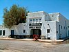 | December 10, 1980 (#80000802) | State Route 127 and State Route 190 36°18′08″N 116°24′54″W / 36.302222°N 116.415°W / 36.302222; -116.415 (Death Valley Junction Historic District) | Death Valley Junction | |
| 6 | Death Valley Scotty Historic District |  | July 20, 1978 (#78000297) | On State Route 72, Death Valley National Park 37°01′33″N 117°22′02″W / 37.025833°N 117.367222°W / 37.025833; -117.367222 (Death Valley Scotty Historic District) | Death Valley National Park | |
| 7 | Eagle Borax Works |  | December 31, 1974 (#74000338) | Death Valley National Park 36°12′04″N 116°51′54″W / 36.201111°N 116.865°W / 36.201111; -116.865 (Eagle Borax Works) | Furnace Creek | |
| 8 | Fossil Falls Archeological District | 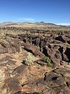 | July 9, 1980 (#80004492) | Restricted | Little Lake | |
| 9 | Harmony Borax Works |  | December 31, 1974 (#74000339) | Death Valley National Park 36°28′47″N 116°52′32″W / 36.479772°N 116.875438°W / 36.479772; -116.875438 (Harmony Borax Works) | Stovepipe Wells | |
| 10 | Inyo County Courthouse |  | January 23, 1998 (#97001664) | 168 N. Edwards Street, Independence 36°48′13″N 118°11′56″W / 36.803611°N 118.198889°W / 36.803611; -118.198889 (Inyo County Courthouse) | Independence | |
| 11 | Laws Narrow Gauge Railroad Historic District |  | October 1, 1981 (#81000149) | U.S. Route 6, northeast of Bishop 37°24′06″N 118°20′50″W / 37.401667°N 118.347222°W / 37.401667; -118.347222 (Laws Narrow Gauge Railroad Historic District) | Laws | |
| 12 | Leadfield |  | June 10, 1975 (#75000221) | Death Valley National Park, on Titus Canyon Trail 36°50′50″N 117°03′27″W / 36.847222°N 117.0575°W / 36.847222; -117.0575 (Leadfield) | Death Valley National Park | |
| 13 | Manzanar War Relocation Center, National Historic Site |  | July 30, 1976 (#76000484) | U.S. Route 395; 6 miles south of Independence 36°43′42″N 118°09′16″W / 36.728333°N 118.154444°W / 36.728333; -118.154444 (Manzanar War Relocation Center, National Historic Site) | Independence | |
| 14 | Pawona Witu | Upload image | October 14, 1975 (#75000428) | Address Restricted | Bishop | |
| 15 | Reilly | Upload image | January 2, 2004 (#03001358) | West side of the Panamint Valley 36°00′25″N 117°22′08″W / 36.006944°N 117.368889°W / 36.006944; -117.368889 (Reilly) | Trona | |
| 16 | Saline Valley Salt Tram Historic Structure |  | December 31, 1974 (#74000514) | Inyo Mountains, north of Keeler between Gordo Peak and New York Butte 36°36′39″N 117°51′19″W / 36.610833°N 117.855278°W / 36.610833; -117.855278 (Saline Valley Salt Tram Historic Structure) | Inyo Mountains | |
| 17 | Skidoo | 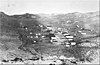 | April 16, 1974 (#74000349) | Death Valley National Park, Wildrose District 36°25′59″N 117°07′46″W / 36.433056°N 117.129444°W / 36.433056; -117.129444 (Skidoo) | Death Valley National Park |
See also
Wikimedia Commons has media related to National Register of Historic Places in Inyo County, California.
- List of National Historic Landmarks in California
- National Register of Historic Places listings in California
- California Historical Landmarks in Inyo County, California
References
- ^ The latitude and longitude information provided in this table was derived originally from the National Register Information System, which has been found to be fairly accurate for about 99% of listings. Some locations in this table may have been corrected to current GPS standards.
- ^ National Park Service, United States Department of the Interior, "National Register of Historic Places: Weekly List Actions", retrieved April 19, 2024.
- ^ Numbers represent an alphabetical ordering by significant words. Various colorings, defined here, differentiate National Historic Landmarks and historic districts from other NRHP buildings, structures, sites or objects.
- ^ "National Register Information System". National Register of Historic Places. National Park Service. July 9, 2010.
- ^ The eight-digit number below each date is the number assigned to each location in the National Register Information System database, which can be viewed by clicking the number.
- v
- t
- e
- List of U.S. National Historic Landmarks by state:
- Alabama
- Alaska
- Arizona
- Arkansas
- California
- Colorado
- Connecticut
- Delaware
- Florida
- Georgia
- Hawaii
- Idaho
- Illinois
- Indiana
- Iowa
- Kansas
- Kentucky
- Louisiana
- Maine
- Maryland
- Massachusetts
- Michigan
- Minnesota
- Mississippi
- Missouri
- Montana
- Nebraska
- Nevada
- New Hampshire
- New Jersey
- New Mexico
- New York
- North Carolina
- North Dakota
- Ohio
- Oklahoma
- Oregon
- Pennsylvania
- Rhode Island
- South Carolina
- South Dakota
- Tennessee
- Texas
- Utah
- Vermont
- Virginia
- Washington
- West Virginia
- Wisconsin
- Wyoming
 National Register of Historic Places portal
 Category


Municipalities and communities of Inyo County, California, United States | ||
|---|---|---|
County seat: Independence | ||
| City |  | |
| CDPs | ||
| Unincorporated communities | ||
| Indian reservations | ||
| Ghost towns | ||
| Other | ||
| ||


