National Register of Historic Places listings in Marion County, Arkansas

This is a list of the National Register of Historic Places listings in Marion County, Arkansas.
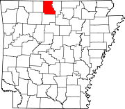
This is intended to be a complete list of the properties and districts on the National Register of Historic Places in Marion County, Arkansas, United States. The locations of National Register properties and districts for which the latitude and longitude coordinates are included below, may be seen in a map.[1]
There are 26 properties and districts listed on the National Register in the county, and one former listing.
This National Park Service list is complete through NPS recent listings posted September 13, 2024.[2]
Map all coordinates using OpenStreetMap
Download coordinates as:
- KML
- GPX (all coordinates)
- GPX (primary coordinates)
- GPX (secondary coordinates)
Current listings
| [3] | Name on the Register[4] | Image | Date listed[5] | Location | City or town | Description |
|---|---|---|---|---|---|---|
| 1 | Aggie Hall | 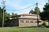 | September 4, 1992 (#92001115) | County Road 9 36°08′30″N 92°46′51″W / 36.141667°N 92.780833°W / 36.141667; -92.780833 (Aggie Hall) | Bruno | |
| 2 | Aggie Workshop |  | September 4, 1992 (#92001113) | Highway 235S 36°08′32″N 92°46′51″W / 36.142222°N 92.780833°W / 36.142222; -92.780833 (Aggie Workshop) | Bruno | |
| 3 | J.C. Berry's Dry Goods Store |  | May 30, 2003 (#03000468) | 331 Old South Main St. 36°13′29″N 92°40′53″W / 36.224722°N 92.681389°W / 36.224722; -92.681389 (J.C. Berry's Dry Goods Store) | Yellville | |
| 4 | Buffalo River State Park | 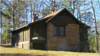 | October 20, 1988 (#78003461) | Buffalo National River 36°04′41″N 92°34′06″W / 36.078056°N 92.568333°W / 36.078056; -92.568333 (Buffalo River State Park) | Yellville | |
| 5 | Carter-Jones House | 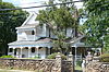 | July 21, 1987 (#87000979) | 30 Carter St. 36°13′37″N 92°41′00″W / 36.226944°N 92.683333°W / 36.226944; -92.683333 (Carter-Jones House) | Yellville | |
| 6 | Cold Springs School | 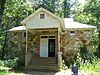 | October 29, 1992 (#92001494) | Cold Spring Hollow, just east of the Buffalo National River 36°04′53″N 92°28′01″W / 36.081389°N 92.466944°W / 36.081389; -92.466944 (Cold Springs School) | Big Flat | |
| 7 | Cotter Tunnel | Upload image | September 19, 2007 (#07000961) | Under U.S. Route 62 east of County Road 724 36°16′41″N 92°32′53″W / 36.278056°N 92.548056°W / 36.278056; -92.548056 (Cotter Tunnel) | Cotter | |
| 8 | Cowdrey House |  | July 20, 1978 (#78000609) | 1 Valley St. 36°13′27″N 92°40′48″W / 36.224167°N 92.68°W / 36.224167; -92.68 (Cowdrey House) | Yellville | |
| 9 | Crooked Creek Bridge | 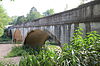 | January 21, 2010 (#09001253) | U.S. Route 62S over Crooked Creek 36°14′53″N 92°50′38″W / 36.248019°N 92.843964°W / 36.248019; -92.843964 (Crooked Creek Bridge) | Pyatt | |
| 10 | Eros School Building | 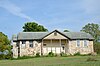 | September 4, 1992 (#92001110) | County Road 9 36°10′58″N 92°51′00″W / 36.182778°N 92.85°W / 36.182778; -92.85 (Eros School Building) | Eros | |
| 11 | Estes-Williams American Legion Hut #61 | Upload image | February 16, 2001 (#01000111) | U.S. Highways 62/412 36°13′34″N 92°40′49″W / 36.226111°N 92.680278°W / 36.226111; -92.680278 (Estes-Williams American Legion Hut #61) | Yellville | |
| 12 | Fairview School Building | 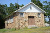 | September 4, 1992 (#92001116) | County Road 203 36°20′02″N 92°36′20″W / 36.333889°N 92.605556°W / 36.333889; -92.605556 (Fairview School Building) | Fairview | |
| 13 | Flippin City Jail | Upload image | March 20, 2023 (#100008565) | Southwest corner of Park and South 2nd Sts. 36°16′36″N 92°35′57″W / 36.2768°N 92.5991°W / 36.2768; -92.5991 (Flippin City Jail) | Flippin | |
| 14 | Hirst-Mathew Hall |  | September 4, 1992 (#92001114) | Highway 235S 36°08′31″N 92°46′53″W / 36.141944°N 92.781389°W / 36.141944; -92.781389 (Hirst-Mathew Hall) | Bruno | |
| 15 | William Jasper Johnson House | Upload image | September 12, 2018 (#100002949) | N of jct. of Lakeshore Rd. & Honeysuckle Ave. 36°23′05″N 92°34′40″W / 36.3847°N 92.5779°W / 36.3847; -92.5779 (William Jasper Johnson House) | Bull Shoals | |
| 16 | Layton Building | 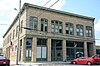 | April 26, 1978 (#78000610) | 1110 Mill St. 36°13′32″N 92°40′57″W / 36.225556°N 92.6825°W / 36.225556; -92.6825 (Layton Building) | Yellville | |
| 17 | Marion County Courthouse |  | May 19, 1994 (#94000471) | Courthouse Square 36°13′33″N 92°40′55″W / 36.225833°N 92.681944°W / 36.225833; -92.681944 (Marion County Courthouse) | Yellville | |
| 18 | Mountain Village 1890 | Upload image | May 8, 2023 (#100008598) | 1011 CS Woods Blvd. 36°22′46″N 92°35′02″W / 36.3794°N 92.5838°W / 36.3794; -92.5838 (Mountain Village 1890) | Bull Shoals | |
| 19 | Pea Ridge School Building |  | June 8, 1993 (#93000486) | East of County Road 6, approximately 4 miles south of Bruno 36°05′41″N 92°45′24″W / 36.094722°N 92.756667°W / 36.094722; -92.756667 (Pea Ridge School Building) | Bruno | |
| 20 | Pyatt School Building |  | September 4, 1992 (#92001111) | County Road 12 36°14′38″N 92°50′42″W / 36.243889°N 92.845°W / 36.243889; -92.845 (Pyatt School Building) | Pyatt | |
| 21 | Pyatt Tunnel | Upload image | September 19, 2007 (#07000953) | Underneath MC 4008 approximately 1 mile south of U.S. Route 62 36°14′31″N 92°49′17″W / 36.241944°N 92.821389°W / 36.241944; -92.821389 (Pyatt Tunnel) | Pyatt | |
| 22 | Rush Historic District |  | February 27, 1987 (#87000105) | Rush Rd. 36°07′37″N 92°33′10″W / 36.126944°N 92.552778°W / 36.126944; -92.552778 (Rush Historic District) | Yellville | |
| 23 | Sunburst Shelter | Upload image | May 4, 1982 (#82002123) | Address Restricted | Summit | |
| 24 | US 62 Bridge over Crooked Creek | Upload image | June 9, 2000 (#00000632) | U.S. Route 62 36°14′45″N 92°50′04″W / 36.245833°N 92.834444°W / 36.245833; -92.834444 (US 62 Bridge over Crooked Creek) | Pyatt | |
| 25 | WPA Privy | Upload image | September 5, 2024 (#100010838) | Southwest of the East Hanson Street and Bright Loop intersection 36°15′14″N 92°50′29″W / 36.2538°N 92.8415°W / 36.2538; -92.8415 (WPA Privy) | Pyatt | |
| 26 | Yellville West Overpass | Upload image | September 10, 2024 (#100010839) | Marion County Road 4052. approximately 325 feet (99 m) west of U.S. 62/412 36°15′11″N 92°43′03″W / 36.2531°N 92.7174°W / 36.2531; -92.7174 (Yellville West Overpass) | Yellville |
Former listing
| [3] | Name on the Register | Image | Date listed | Date removed | Location | City or town | Description |
|---|---|---|---|---|---|---|---|
| 1 | Bruno School Building | Upload image | September 4, 1992 (#92001112) | January 24, 2017 | County Road 9 36°08′32″N 92°46′49″W / 36.142222°N 92.780278°W / 36.142222; -92.780278 (Bruno School Building) | Bruno |
See also
Wikimedia Commons has media related to National Register of Historic Places in Marion County, Arkansas.
- List of National Historic Landmarks in Arkansas
- National Register of Historic Places listings in Buffalo National River
- National Register of Historic Places listings in Arkansas
References
- ^ The latitude and longitude information provided in this table was derived originally from the National Register Information System, which has been found to be fairly accurate for about 99% of listings. Some locations in this table may have been corrected to current GPS standards.
- ^ National Park Service, United States Department of the Interior, "National Register of Historic Places: Weekly List Actions", retrieved September 13, 2024.
- ^ a b Numbers represent an alphabetical ordering by significant words. Various colorings, defined here, differentiate National Historic Landmarks and historic districts from other NRHP buildings, structures, sites or objects.
- ^ "National Register Information System". National Register of Historic Places. National Park Service. March 13, 2009.
- ^ The eight-digit number below each date is the number assigned to each location in the National Register Information System database, which can be viewed by clicking the number.
- v
- t
- e
- List of U.S. National Historic Landmarks by state:
- Alabama
- Alaska
- Arizona
- Arkansas
- California
- Colorado
- Connecticut
- Delaware
- Florida
- Georgia
- Hawaii
- Idaho
- Illinois
- Indiana
- Iowa
- Kansas
- Kentucky
- Louisiana
- Maine
- Maryland
- Massachusetts
- Michigan
- Minnesota
- Mississippi
- Missouri
- Montana
- Nebraska
- Nevada
- New Hampshire
- New Jersey
- New Mexico
- New York
- North Carolina
- North Dakota
- Ohio
- Oklahoma
- Oregon
- Pennsylvania
- Rhode Island
- South Carolina
- South Dakota
- Tennessee
- Texas
- Utah
- Vermont
- Virginia
- Washington
- West Virginia
- Wisconsin
- Wyoming
 National Register of Historic Places portal
 Category