National Register of Historic Places listings in Montgomery County, Kansas

This is a list of the National Register of Historic Places listings in Montgomery County, Kansas.
This is intended to be a complete list of the properties and districts on the National Register of Historic Places in Montgomery County, Kansas, United States. The locations of National Register properties and districts for which the latitude and longitude coordinates are included below, may be seen in a map.[1]
There are 36 properties and districts listed on the National Register in the county.
This National Park Service list is complete through NPS recent listings posted September 13, 2024.[2]
Map all coordinates using OpenStreetMap
Download coordinates as:
- KML
- GPX (all coordinates)
- GPX (primary coordinates)
- GPX (secondary coordinates)
Current listings
| [3] | Name on the Register[4] | Image | Date listed[5] | Location | City or town | Description |
|---|---|---|---|---|---|---|
| 1 | Archeological Site Number 14MY1 | Upload image | July 9, 1982 (#82004886) | Address restricted | ||
| 2 | Archeological Site Number 14MY365 | Upload image | July 9, 1982 (#82004885) | Address restricted | Independence | |
| 3 | Archeological Site Number 14MY1320 | Upload image | July 9, 1982 (#82004883) | Address restricted | Independence | |
| 4 | Archeological Site Number 14MY1385 | Upload image | July 9, 1982 (#82004884) | Address restricted | Liberty | |
| 5 | Charles M. Ball House |  | February 7, 2011 (#10001209) | 702 Spruce St. 37°02′14″N 95°37′20″W / 37.037222°N 95.622222°W / 37.037222; -95.622222 (Charles M. Ball House) | Coffeyville | |
| 6 | Bethel African Methodist Episcopal Church |  | July 28, 1995 (#95000943) | 202 W. 12th St. 37°01′56″N 95°37′02″W / 37.032222°N 95.617222°W / 37.032222; -95.617222 (Bethel African Methodist Episcopal Church) | Coffeyville | |
| 7 | Blakeslee Motor Company Building |  | August 25, 1989 (#89001145) | 211 W. Myrtle 37°13′27″N 95°42′32″W / 37.224056°N 95.708779°W / 37.224056; -95.708779 (Blakeslee Motor Company Building) | Independence | |
| 8 | Booth Hotel |  | April 28, 1983 (#83000435) | 201-209 W. Main St. 37°13′23″N 95°42′30″W / 37.223041°N 95.708404°W / 37.223041; -95.708404 (Booth Hotel) | Independence | |
| 9 | Booth Theater | 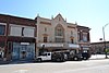 | October 13, 1988 (#88001903) | 119 W. Myrtle St. 37°13′27″N 95°42′28″W / 37.224138°N 95.70775°W / 37.224138; -95.70775 (Booth Theater) | Independence | |
| 10 | Brown Barn | Upload image | April 8, 2009 (#09000191) | 5879 County Road 4300 37°08′19″N 95°40′27″W / 37.138611°N 95.674167°W / 37.138611; -95.674167 (Brown Barn) | Independence | Agriculture-Related Resources of Kansas MPS |
| 11 | W.P. Brown Mansion |  | December 12, 1976 (#76000833) | S. Walnut and Eldridge Sts. 37°01′13″N 95°36′50″W / 37.020278°N 95.613889°W / 37.020278; -95.613889 (W.P. Brown Mansion) | Coffeyville | |
| 12 | Cedar Manor Farm | Upload image | January 8, 2014 (#13001041) | 2326 Cty. Rd. 6400 37°33′36″N 95°55′29″W / 37.559919°N 95.924591°W / 37.559919; -95.924591 (Cedar Manor Farm) | Fredonia | Part of the Agriculture-Related Resources of Kansas MPS |
| 13 | Cherryvale Carnegie Free Library | Upload image | August 18, 1987 (#87000961) | 329 E. Main 37°16′01″N 95°32′55″W / 37.266944°N 95.548611°W / 37.266944; -95.548611 (Cherryvale Carnegie Free Library) | Cherryvale | |
| 14 | Coffeyville Carnegie Public Library Building |  | June 25, 1987 (#87000962) | 415 W. Eighth 37°02′09″N 95°37′23″W / 37.035833°N 95.623056°W / 37.035833; -95.623056 (Coffeyville Carnegie Public Library Building) | Coffeyville | |
| 15 | Condon National Bank |  | January 12, 1973 (#73000771) | 811 Walnut St. 37°02′08″N 95°36′55″W / 37.035556°N 95.615278°W / 37.035556; -95.615278 (Condon National Bank) | Coffeyville | |
| 16 | Cook's Hotel |  | March 8, 2006 (#06000115) | 113 West Myrtle 37°13′27″N 95°42′27″W / 37.224172°N 95.707489°W / 37.224172; -95.707489 (Cook's Hotel) | Independence | |
| 17 | Dewlen-Spohnhauer Bridge |  | March 10, 1983 (#83000436) | Old U.S. Route 160 37°13′28″N 95°40′43″W / 37.224444°N 95.678611°W / 37.224444; -95.678611 (Dewlen-Spohnhauer Bridge) | Independence | |
| 18 | Eastep Site | Upload image | January 30, 2013 (#12001240) | Address restricted | Independence | |
| 19 | Elk River Archeological District | Upload image | September 13, 1978 (#78001279) | Address restricted | Elk City | |
| 20 | Federal Building-US Post Office |  | October 19, 1988 (#88002009) | 123 N. 8th 37°13′27″N 95°42′30″W / 37.224081°N 95.708431°W / 37.224081; -95.708431 (Federal Building-US Post Office) | Independence | |
| 21 | First Congregational Church |  | October 8, 2014 (#14000831) | 400 N. 9th 37°13′36″N 95°42′33″W / 37.2267°N 95.7092°W / 37.2267; -95.7092 (First Congregational Church) | Independence | |
| 22 | Hotel Dale | 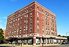 | January 31, 2008 (#07001483) | 206 W. 8th St. 37°02′10″N 95°37′02″W / 37.036111°N 95.617222°W / 37.036111; -95.617222 (Hotel Dale) | Coffeyville | |
| 23 | Independence Bowstring | 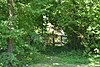 | January 4, 1990 (#89002180) | Over the Verdigris River, north of junction of Burns and Myrtle Sts. 37°13′29″N 95°41′37″W / 37.224722°N 95.693611°W / 37.224722; -95.693611 (Independence Bowstring) | Independence | |
| 24 | Independence Downtown Historic District |  | July 19, 2006 (#06000624) | Chestnut, Laurel, Myrtle, Main, Maple between 5th and 9th 37°13′30″N 95°42′18″W / 37.225°N 95.705°W / 37.225; -95.705 (Independence Downtown Historic District) | Independence | |
| 25 | Independence Junior High School |  | December 30, 2009 (#09001165) | 300 W. Locust St. 37°13′41″N 95°42′37″W / 37.228°N 95.710139°W / 37.228; -95.710139 (Independence Junior High School) | Independence | |
| 26 | Independence Public Carnegie Library |  | January 11, 1988 (#87002231) | 220 E. Maple 37°13′21″N 95°42′16″W / 37.222483°N 95.704322°W / 37.222483; -95.704322 (Independence Public Carnegie Library) | Independence | |
| 27 | Infinity Archeological Site | Upload image | March 24, 1971 (#71000320) | Southwest of the confluence of the Elk River and Card Creek[6] 37°15′09″N 95°51′20″W / 37.252500°N 95.855556°W / 37.252500; -95.855556 (Infinity Archeological Site) | Independence | |
| 28 | William Inge Boyhood Home | 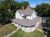 | January 5, 2018 (#100001947) | 514 N 4th St. 37°13′42″N 95°42′09″W / 37.228231°N 95.702451°W / 37.228231; -95.702451 (William Inge Boyhood Home) | Independence | |
| 29 | Memorial Hall |  | June 10, 2005 (#05000554) | Junction of Pennsylvania Ave. and E. Locust St. 37°13′38″N 95°42′22″W / 37.227242°N 95.706157°W / 37.227242; -95.706157 (Memorial Hall) | Independence | |
| 30 | Midland Theater |  | February 9, 2005 (#05000007) | 212-214 W. 8th St. 37°02′17″N 95°36′58″W / 37.038056°N 95.616111°W / 37.038056; -95.616111 (Midland Theater) | Coffeyville | |
| 31 | Onion Creek Bridge |  | January 4, 1990 (#89002172) | Over Onion Creek, south of Coffeyville 37°01′33″N 95°39′23″W / 37.025833°N 95.656389°W / 37.025833; -95.656389 (Onion Creek Bridge) | Coffeyville | |
| 32 | Pennsylvania Avenue Rock Creek Bridge |  | July 2, 1985 (#85001437) | Pennsylvania Ave. over Rock Creek 37°12′51″N 95°42′26″W / 37.214250°N 95.707258°W / 37.214250; -95.707258 (Pennsylvania Avenue Rock Creek Bridge) | Independence | |
| 33 | Prairie Oil & Gas Building | Upload image | August 5, 2024 (#100010595) | 200 Arco Place (300 West Myrtle Street) 37°13′29″N 95°42′35″W / 37.2246°N 95.7096°W / 37.2246; -95.7096 (Prairie Oil & Gas Building) | Independence | |
| 34 | Terminal Building | Upload image | June 14, 1982 (#82002666) | 717 Walnut 37°02′11″N 95°36′54″W / 37.036389°N 95.615°W / 37.036389; -95.615 (Terminal Building) | Coffeyville | |
| 35 | Union Implement and Hardware Building-Masonic Temple |  | October 13, 1988 (#88002008) | 121-123 W. Main 37°13′23″N 95°42′28″W / 37.222963°N 95.707879°W / 37.222963; -95.707879 (Union Implement and Hardware Building-Masonic Temple) | Independence | |
| 36 | Washington School | Upload image | April 14, 2015 (#15000147) | 300 E. Myrtle St. 37°13′30″N 95°42′11″W / 37.224935°N 95.703107°W / 37.224935; -95.703107 (Washington School) | Independence |
See also
Wikimedia Commons has media related to National Register of Historic Places in Montgomery County, Kansas.
- List of National Historic Landmarks in Kansas
- National Register of Historic Places listings in Kansas
References
- ^ The latitude and longitude information provided in this table was derived originally from the National Register Information System, which has been found to be fairly accurate for about 99% of listings. Some locations in this table may have been corrected to current GPS standards.
- ^ National Park Service, United States Department of the Interior, "National Register of Historic Places: Weekly List Actions", retrieved September 13, 2024.
- ^ Numbers represent an alphabetical ordering by significant words. Various colorings, defined here, differentiate National Historic Landmarks and historic districts from other NRHP buildings, structures, sites or objects.
- ^ "National Register Information System". National Register of Historic Places. National Park Service. March 13, 2009.
- ^ The eight-digit number below each date is the number assigned to each location in the National Register Information System database, which can be viewed by clicking the number.
- ^ Hawley, Marlin F., and Richard E. Hughes. "A Source Study of Obsidian from the Infinity Site (14MY305), Kansas". Plains Anthropologist 44.169 (1999): 297-305: 297.
- v
- t
- e

- Allen
- Anderson
- Atchison
- Barber
- Barton
- Bourbon
- Brown
- Butler
- Chase
- Chautauqua
- Cherokee
- Cheyenne
- Clark
- Clay
- Cloud
- Coffey
- Comanche
- Cowley
- Crawford
- Decatur
- Dickinson
- Doniphan
- Douglas
- Edwards
- Elk
- Ellis
- Ellsworth
- Finney
- Ford
- Franklin
- Geary
- Gove
- Graham
- Grant
- Gray
- Greeley
- Greenwood
- Hamilton
- Harper
- Harvey
- Haskell
- Hodgeman
- Jackson
- Jefferson
- Jewell
- Johnson
- Kearny
- Kingman
- Kiowa
- Labette
- Lane
- Leavenworth
- Lincoln
- Linn
- Logan
- Lyon
- Marion
- McPherson
- Meade
- Miami
- Mitchell
- Montgomery
- Morris
- Morton
- Nemaha
- Neosho
- Ness
- Norton
- Osage
- Osborne
- Ottawa
- Pawnee
- Phillips
- Pottawatomie
- Pratt
- Rawlins
- Reno
- Republic
- Rice
- Riley
- Rooks
- Rush
- Russell
- Saline
- Scott
- Sedgwick
- Seward
- Shawnee
- Sheridan
- Sherman
- Smith
- Stafford
- Stanton
- Stevens
- Sumner
- Thomas
- Trego
- Wabaunsee
- Wallace
- Washington
- Wichita
- Wilson
- Woodson
- Wyandotte
- Archaeological sites
- National Historic Landmarks
 Category
 NRHP portal


Municipalities and communities of Montgomery County, Kansas, United States | ||
|---|---|---|
County seat: Independence | ||
| Cities |  | |
| CDPs | ||
| Unincorporated communities | ||
| Ghost towns | ||
| Townships |
| |
| ||


