National Register of Historic Places listings in Napa County, California

This is a list of the National Register of Historic Places listings in Napa County, California.
This is intended to be a complete list of the properties and districts on the National Register of Historic Places in Napa County, California, United States. Latitude and longitude coordinates are provided for many National Register properties and districts; these locations may be seen together in an online map.[1]
There are 88 properties and districts listed on the National Register in the county, including 1 National Historic Landmark.
This National Park Service list is complete through NPS recent listings posted April 19, 2024.[2]
Map all coordinates using OpenStreetMap
Download coordinates as:
- KML
- GPX (all coordinates)
- GPX (primary coordinates)
- GPX (secondary coordinates)
Current listings
| [3] | Name on the Register[4] | Image | Date listed[5] | Location | City or town | Description |
|---|---|---|---|---|---|---|
| 1 | Aetna Springs Resort |  | March 9, 1987 (#87000341) | 1600 Aetna Springs Rd. 38°39′06″N 122°29′06″W / 38.651667°N 122.485°W / 38.651667; -122.485 (Aetna Springs Resort) | Pope Valley | |
| 2 | Alexandria Hotel and Annex | 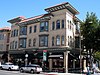 | January 11, 1982 (#82002212) | 840-844 Brown St. 38°17′54″N 122°17′02″W / 38.298333°N 122.283889°W / 38.298333; -122.283889 (Alexandria Hotel and Annex) | Napa | |
| 3 | William Andrews House | 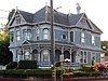 | June 18, 1992 (#92000789) | 741 Seminary St. 38°17′43″N 122°17′27″W / 38.295278°N 122.290833°W / 38.295278; -122.290833 (William Andrews House) | Napa | |
| 4 | Atkinson House |  | September 13, 1990 (#90001443) | 8440 St. Helena Hwy. 38°27′14″N 122°24′48″W / 38.453889°N 122.413333°W / 38.453889; -122.413333 (Atkinson House) | Rutherford | |
| 5 | Bale Mill | 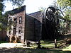 | June 22, 1972 (#72000240) | 3 miles (4.8 km) northwest of St. Helena off CA 128 38°32′29″N 122°30′30″W / 38.541389°N 122.508333°W / 38.541389; -122.508333 (Bale Mill) | St. Helena | |
| 6 | Bank of Napa | 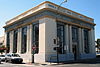 | June 18, 1992 (#92000785) | 903 Main St. and 908 Brown St. 38°17′57″N 122°17′05″W / 38.299167°N 122.284722°W / 38.299167; -122.284722 (Bank of Napa) | Napa | |
| 7 | Beringer Brothers-Los Hermanos Winery |  | August 17, 2001 (#01000878) | 2000 Main St. 38°30′41″N 122°28′46″W / 38.511389°N 122.479444°W / 38.511389; -122.479444 (Beringer Brothers-Los Hermanos Winery) | St. Helena | |
| 8 | Sam Brannan Cottage |  | August 18, 1983 (#83001211) | 109 Wapoo Ave. 38°34′56″N 122°34′34″W / 38.582222°N 122.576111°W / 38.582222; -122.576111 (Sam Brannan Cottage) | Calistoga | |
| 9 | Buford House |  | November 11, 1977 (#77000314) | 1930 Clay St. 38°17′55″N 122°17′38″W / 38.298611°N 122.293889°W / 38.298611; -122.293889 (Buford House) | Napa | |
| 10 | Carneros Creek Bridge on Old Sonoma Road |  | August 5, 2005 (#05000779) | Old Sonoma Rd., 0.2 miles (0.32 km) northeast of CA 12/CA 121 38°15′24″N 122°20′22″W / 38.256667°N 122.339444°W / 38.256667; -122.339444 (Carneros Creek Bridge on Old Sonoma Road) | Napa | |
| 11 | Chateau Chevalier | Upload image | June 12, 1987 (#87000926) | 3101 Spring Mountain Rd. 38°30′53″N 122°30′35″W / 38.514722°N 122.509722°W / 38.514722; -122.509722 (Chateau Chevalier) | St. Helena | |
| 12 | Chateau Pacheteau |  | December 22, 2015 (#15000913) | 1670 Diamond Mountain Rd. 38°33′50″N 122°34′45″W / 38.563857°N 122.579029°W / 38.563857; -122.579029 (Chateau Pacheteau) | Calistoga | |
| 13 | Churchill Manor |  | April 18, 1977 (#77000315) | 485 Brown St. 38°17′35″N 122°16′59″W / 38.293056°N 122.283056°W / 38.293056; -122.283056 (Churchill Manor) | Napa | |
| 14 | Thomas Earl House |  | August 18, 1992 (#92000996) | 1221 Seminary St. 38°17′58″N 122°17′24″W / 38.299444°N 122.29°W / 38.299444; -122.29 (Thomas Earl House) | Napa | |
| 15 | Elmshaven |  | November 4, 1993 (#93001609) | 125 Glass Mountain Ln. 38°32′13″N 122°28′41″W / 38.536944°N 122.478056°W / 38.536944; -122.478056 (Elmshaven) | St. Helena | |
| 16 | Eshcol Winery |  | July 16, 1987 (#87001155) | 1160 Oak Knoll Ave. 38°21′38″N 122°19′53″W / 38.360556°N 122.331389°W / 38.360556; -122.331389 (Eshcol Winery) | Napa | |
| 17 | Far Niente Winery |  | February 28, 1979 (#79000507) | South of Oakville at 1577 Oakville Grade 38°25′33″N 122°24′07″W / 38.425833°N 122.401944°W / 38.425833; -122.401944 (Far Niente Winery) | Oakville | |
| 18 | First National Bank |  | September 24, 1992 (#92001277) | 1026 First St. 38°17′57″N 122°17′04″W / 38.299167°N 122.284444°W / 38.299167; -122.284444 (First National Bank) | Napa | |
| 19 | First Presbyterian Church |  | June 5, 1975 (#75000446) | 1333 3rd St. 38°17′46″N 122°17′09″W / 38.296111°N 122.285833°W / 38.296111; -122.285833 (First Presbyterian Church) | Napa | |
| 20 | First Street Bridge | 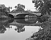 | August 5, 2004 (#04000774) | First St. across the Napa R 38°18′06″N 122°16′42″W / 38.301667°N 122.278333°W / 38.301667; -122.278333 (First Street Bridge) | Napa | |
| 21 | James H. Francis House |  | January 31, 1979 (#79000503) | 1403 Myrtle St. 38°34′36″N 122°34′53″W / 38.576667°N 122.581389°W / 38.576667; -122.581389 (James H. Francis House) | Calistoga | 1886 home of a local merchant; Calistoga Hospital from 1918 to 1965[6] |
| 22 | French Laundry | 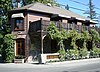 | April 19, 1978 (#78000728) | 6640 Washington St. 38°24′16″N 122°21′50″W / 38.404444°N 122.363889°W / 38.404444; -122.363889 (French Laundry) | Yountville | |
| 23 | Garnett Creek Bridge on CA 29 |  | August 5, 2005 (#05000776) | CA 29 over Garnett Creek at postmile 39.08 38°36′12″N 122°35′20″W / 38.603333°N 122.588889°W / 38.603333; -122.588889 (Garnett Creek Bridge on CA 29) | Calistoga | |
| 24 | Garnett Creek Bridge on Greenwood Avenue | 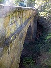 | August 5, 2005 (#05000778) | Greenwood Ave., 0.2 miles (0.32 km) northeast of Grant Ave. 38°35′34″N 122°35′29″W / 38.592778°N 122.591389°W / 38.592778; -122.591389 (Garnett Creek Bridge on Greenwood Avenue) | Calistoga | |
| 25 | Goodman Library |  | January 21, 1974 (#74000539) | 1219 1st St. 38°17′53″N 122°17′10″W / 38.298056°N 122.286111°W / 38.298056; -122.286111 (Goodman Library) | Napa | |
| 26 | George E. Goodman Jr. House | 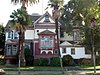 | April 1, 1993 (#93000270) | 492 Randolph St. 38°17′37″N 122°17′05″W / 38.293611°N 122.284722°W / 38.293611; -122.284722 (George E. Goodman Jr. House) | Napa | |
| 27 | George E. Goodman Mansion | 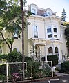 | April 15, 1993 (#93000261) | 1120 Oak St. 38°17′37″N 122°16′56″W / 38.293611°N 122.282222°W / 38.293611; -122.282222 (George E. Goodman Mansion) | Napa | |
| 28 | Gordon Building |  | September 12, 1985 (#85002197) | 1130 1st St. 38°17′56″N 122°17′09″W / 38.298889°N 122.285833°W / 38.298889; -122.285833 (Gordon Building) | Napa | |
| 29 | Greystone Cellars |  | August 10, 1978 (#78000725) | 2555 Main St. 38°30′52″N 122°29′02″W / 38.514444°N 122.483889°W / 38.514444; -122.483889 (Greystone Cellars) | St. Helena | Built in 1889 by William Bowers Bourn II to house Napa Valley's first wine cooperative; later owned and operated by the Christian Brothers and Heublein; now the Culinary Institute of America at Greystone[7] |
| 30 | Groezinger Wine Cellars |  | February 4, 1982 (#82002218) | 6525 Washington St. 38°24′05″N 122°21′44″W / 38.401389°N 122.362222°W / 38.401389; -122.362222 (Groezinger Wine Cellars) | Yountville | |
| 31 | Hackett House | 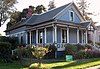 | April 19, 1984 (#84000913) | 2109 1st St. 38°17′50″N 122°17′43″W / 38.297222°N 122.295278°W / 38.297222; -122.295278 (Hackett House) | Napa | |
| 32 | Hatt Building | 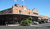 | May 2, 1977 (#77000316) | 5th and Main Sts. 38°17′46″N 122°16′54″W / 38.296111°N 122.281667°W / 38.296111; -122.281667 (Hatt Building) | Napa | |
| 33 | Helios Ranch | 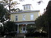 | May 9, 1985 (#85001014) | 1575 St. Helena Hwy. 38°28′37″N 122°26′07″W / 38.476944°N 122.435278°W / 38.476944; -122.435278 (Helios Ranch) | St. Helena | 1884 home of prominent Napa farmer and businessman Theron H. Ink; now the Ink House Bed and Breakfast |
| 34 | Dr. Edwin Hennessey House |  | August 28, 1986 (#86001976) | 1727 Main St. 38°18′16″N 122°17′21″W / 38.304444°N 122.289167°W / 38.304444; -122.289167 (Dr. Edwin Hennessey House) | Napa | 1889 Queen Anne style home of early Napa County physician and surgeon Edwin Z. Hennessey; now the Hennessey House Bed and Breakfast[8] |
| 35 | Cayetano Juarez Adobe |  | April 3, 2015 (#15000122) | 376 Soscol Ave. 38°17′18″N 122°16′30″W / 38.2883°N 122.275°W / 38.2883; -122.275 (Cayetano Juarez Adobe) | Napa | |
| 36 | Sam Kee Laundry Building | 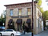 | October 1, 1974 (#74000540) | 1245 Main St. 38°18′04″N 122°17′11″W / 38.301111°N 122.286389°W / 38.301111; -122.286389 (Sam Kee Laundry Building) | Napa | |
| 37 | Kreuzer Ranch | Upload image | February 11, 1982 (#82002214) | 167 Kreuzer Lane 38°17′14″N 122°14′05″W / 38.287222°N 122.234722°W / 38.287222; -122.234722 (Kreuzer Ranch) | Napa | |
| 38 | Charles Krug Winery |  | November 8, 1974 (#74000542) | St. Helena Hwy. 38°31′03″N 122°28′49″W / 38.5175°N 122.480278°W / 38.5175; -122.480278 (Charles Krug Winery) | St. Helena | |
| 39 | Larkmead Winery |  | February 1, 1982 (#82002215) | Northwest of St. Helena at 1091 Larkmead Lane 38°33′33″N 122°31′16″W / 38.559167°N 122.521111°W / 38.559167; -122.521111 (Larkmead Winery) | Calistoga | Building now owned by Frank Family Vineyards |
| 40 | Lisbon Winery | 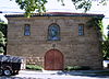 | March 1, 1979 (#79000505) | 1720 Brown St. 38°18′14″N 122°17′20″W / 38.303889°N 122.288889°W / 38.303889; -122.288889 (Lisbon Winery) | Napa | 1882 winery of Joseph A. Mateus (Matthews); now the home of the Jarvis Conservatory |
| 41 | Manasse Mansion | 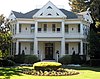 | November 14, 1978 (#78000723) | 443 Brown St. 38°17′34″N 122°17′00″W / 38.292778°N 122.283333°W / 38.292778; -122.283333 (Manasse Mansion) | Napa | |
| 42 | Edward G. Manasse House |  | April 15, 1993 (#93000271) | 495 Coombs St. 38°17′37″N 122°17′02″W / 38.293611°N 122.283889°W / 38.293611; -122.283889 (Edward G. Manasse House) | Napa | |
| 43 | Maxwell Creek Bridge on Hardin Road |  | August 5, 2005 (#05000777) | Hardin Rd., 1.6 miles (2.6 km) southeast of Pope Canyon Rd. 38°36′05″N 122°22′15″W / 38.601389°N 122.370833°W / 38.601389; -122.370833 (Maxwell Creek Bridge on Hardin Road) | Locoallomi | |
| 44 | Migliavacca House |  | March 30, 1978 (#78000724) | 1475 4th St. 38°17′42″N 122°17′14″W / 38.295°N 122.287222°W / 38.295; -122.287222 (Migliavacca House) | Napa | |
| 45 | Milliken Creek Bridge | 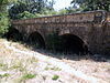 | August 5, 2004 (#04000775) | Trancas St. across Milliken Creek 38°19′30″N 122°16′28″W / 38.325°N 122.274444°W / 38.325; -122.274444 (Milliken Creek Bridge) | Napa | |
| 46 | Monte Vista and Diamond Mountain Vineyard | Upload image | January 9, 2013 (#12001144) | 2121 Diamond Mountain Rd. 38°32′37″N 122°34′48″W / 38.543567°N 122.579981°W / 38.543567; -122.579981 (Monte Vista and Diamond Mountain Vineyard) | Calistoga | |
| 47 | Mount View Hotel | 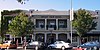 | April 12, 1982 (#82002211) | 1457 Lincoln Ave. 38°34′46″N 122°34′36″W / 38.579444°N 122.576667°W / 38.579444; -122.576667 (Mount View Hotel) | Calistoga | |
| 48 | Napa Abajo-Fuller Park Historic District | 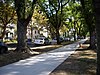 | February 19, 1997 (#97000042) | Roughly bounded by the Napa River, Pine, Jefferson, 3rd, 4th, and Division Sts. 38°17′38″N 122°17′12″W / 38.293889°N 122.286667°W / 38.293889; -122.286667 (Napa Abajo-Fuller Park Historic District) | Napa | |
| 49 | Napa County Courthouse Plaza |  | June 18, 1992 (#92000778) | Bounded by Coombs, Second, Brown and Third Sts. 38°17′51″N 122°17′04″W / 38.2975°N 122.284444°W / 38.2975; -122.284444 (Napa County Courthouse Plaza) | Napa | |
| 50 | Napa County Infirmary | Upload image | June 4, 2018 (#100002380) | 2344 Old Sonoma Rd. 38°17′16″N 122°17′54″W / 38.2878°N 122.2982°W / 38.2878; -122.2982 (Napa County Infirmary) | Napa | |
| 51 | Napa Opera House | 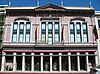 | October 25, 1973 (#73000414) | 1018-1030 Main St. on E side 38°17′59″N 122°17′04″W / 38.299722°N 122.284444°W / 38.299722; -122.284444 (Napa Opera House) | Napa | |
| 52 | Napa River Bridge on Zinfandel Lane | 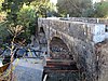 | August 5, 2005 (#05000781) | Zinfandel Ln., 1 mile (1.6 km) east of CA 29 38°29′42″N 122°25′32″W / 38.495°N 122.425556°W / 38.495; -122.425556 (Napa River Bridge on Zinfandel Lane) | St. Helena | 1913 stone arch bridge |
| 53 | Napa Valley Railroad Depot |  | April 18, 1977 (#77000313) | Lincoln Ave. and Fair Way 38°34′48″N 122°34′38″W / 38.58°N 122.577222°W / 38.58; -122.577222 (Napa Valley Railroad Depot) | Calistoga | |
| 54 | Nichelini Winery | 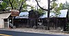 | August 24, 1979 (#79000508) | East of St. Helena at 2950 Sage Canyon Rd 38°29′57″N 122°17′33″W / 38.499167°N 122.2925°W / 38.499167; -122.2925 (Nichelini Winery) | St. Helena | |
| 55 | Noyes Mansion |  | June 18, 1992 (#92000788) | 1750 First St. 38°17′51″N 122°17′31″W / 38.2975°N 122.291944°W / 38.2975; -122.291944 (Noyes Mansion) | Napa | |
| 56 | Oakville Grocery |  | July 22, 1993 (#93000664) | 7856 St. Helena Hwy. 38°26′15″N 122°24′06″W / 38.4375°N 122.401667°W / 38.4375; -122.401667 (Oakville Grocery) | Oakville | |
| 57 | Old Napa Register Building |  | February 19, 1982 (#82002213) | 1202 1st St. 38°17′56″N 122°17′10″W / 38.298889°N 122.286111°W / 38.298889; -122.286111 (Old Napa Register Building) | Napa | |
| 58 | Judge Augustus C. Palmer House | 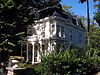 | January 31, 1979 (#79000504) | 1300 Cedar St. 38°34′39″N 122°34′46″W / 38.5775°N 122.579444°W / 38.5775; -122.579444 (Judge Augustus C. Palmer House) | Calistoga | |
| 59 | Capt. George Pinkham House |  | June 18, 1992 (#92000786) | 529-531 Brown St. 38°17′39″N 122°16′57″W / 38.294167°N 122.2825°W / 38.294167; -122.2825 (Capt. George Pinkham House) | Napa | |
| 60 | Pope Street Bridge |  | October 5, 1972 (#72000241) | Pope St., over the Napa River 38°30′40″N 122°27′21″W / 38.511111°N 122.455833°W / 38.511111; -122.455833 (Pope Street Bridge) | St. Helena | |
| 61 | John Ramos Sherry House-Depot Saloon |  | August 30, 2007 (#07000849) | 1468-1478 Railroad Ave. 38°30′25″N 122°28′14″W / 38.506867°N 122.470553°W / 38.506867; -122.470553 (John Ramos Sherry House-Depot Saloon) | St. Helena | |
| 62 | Rhine House | 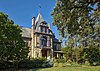 | February 23, 1972 (#72000242) | 2000 Main St. 38°30′37″N 122°29′25″W / 38.510278°N 122.490278°W / 38.510278; -122.490278 (Rhine House) | St. Helena | |
| 63 | Charles Rovegno House |  | September 13, 1991 (#91001384) | 6711 Washington St. 38°24′20″N 122°21′56″W / 38.405556°N 122.365556°W / 38.405556; -122.365556 (Charles Rovegno House) | Yountville | |
| 64 | St. Helena Catholic Church |  | May 23, 1978 (#78000726) | Oak and Tainter Sts. 38°30′13″N 122°28′09″W / 38.503611°N 122.469167°W / 38.503611; -122.469167 (St. Helena Catholic Church) | St. Helena | |
| 65 | St. Helena High School |  | May 22, 1978 (#78000727) | 437 Main St. 38°29′51″N 122°27′38″W / 38.4975°N 122.460556°W / 38.4975; -122.460556 (St. Helena High School) | St. Helena | |
| 66 | St. Helena Historic Commercial District |  | January 23, 1998 (#97001661) | Along Main St., between Adams and Spring Sts. 38°30′17″N 122°28′05″W / 38.504722°N 122.468056°W / 38.504722; -122.468056 (St. Helena Historic Commercial District) | St. Helena | |
| 67 | St. Helena Public Cemetery | Upload image | October 1, 2018 (#100002994) | 2461 Spring St. 38°29′36″N 122°28′34″W / 38.4934°N 122.4762°W / 38.4934; -122.4762 (St. Helena Public Cemetery) | St. Helena | |
| 68 | St. Helena Public Library | 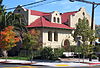 | January 19, 1979 (#79000509) | 1360 Oak Ave. 38°30′16″N 122°28′11″W / 38.504444°N 122.469722°W / 38.504444; -122.469722 (St. Helena Public Library) | St. Helena | |
| 69 | Saint Helena Southern Pacific Railroad Depot |  | January 7, 1997 (#96001535) | Railroad Ave., northeast of the junction of Main St. and Madrona Ave. 38°30′27″N 122°28′13″W / 38.5075°N 122.470278°W / 38.5075; -122.470278 (Saint Helena Southern Pacific Railroad Depot) | St. Helena | Southern Pacific standard plan No. 18 two-story combination depot.[9] |
| 70 | Schramsberg Vineyards |  | October 22, 1998 (#98001251) | 1400 Schramsberg Rd. 38°33′11″N 122°32′20″W / 38.553056°N 122.538889°W / 38.553056; -122.538889 (Schramsberg Vineyards) | Calistoga | |
| 71 | Semorile Building |  | November 21, 1974 (#74000541) | 975 1st St. 38°17′57″N 122°17′02″W / 38.299167°N 122.283889°W / 38.299167; -122.283889 (Semorile Building) | Napa | |
| 72 | Williams Smith House |  | June 30, 1995 (#95000786) | 1929 First St. 38°17′51″N 122°17′38″W / 38.2975°N 122.293889°W / 38.2975; -122.293889 (Williams Smith House) | Napa | Circa 1875 Second Empire-style house of late 19th-century Napa businessman Williams Smith[10] |
| 73 | Special Internal Revenue Bonded Warehouse, First District, No. 13 |  | October 5, 1995 (#95001154) | 1216 Church St. 38°30′17″N 122°27′58″W / 38.504722°N 122.466111°W / 38.504722; -122.466111 (Special Internal Revenue Bonded Warehouse, First District, No. 13) | St. Helena | |
| 74 | Suscol House |  | February 28, 1979 (#79000506) | South of Napa on Old Suscol Ferry Rd. 38°14′24″N 122°16′06″W / 38.24°N 122.268333°W / 38.24; -122.268333 (Suscol House) | Napa | |
| 75 | Swartz Creek Bridge on Aetna Springs Road |  | August 5, 2005 (#05000780) | Aetna Springs Rd., 0.8 miles (1.3 km) west of Pope Valley Rd. 38°39′12″N 122°28′32″W / 38.653333°N 122.475556°W / 38.653333; -122.475556 (Swartz Creek Bridge on Aetna Springs Road) | Aetna Springs | |
| 76 | Taylor, Duckworth and Company Foundry Building |  | January 21, 1982 (#82002216) | 1345 Railroad Ave. 38°30′18″N 122°28′05″W / 38.505°N 122.468056°W / 38.505; -122.468056 (Taylor, Duckworth and Company Foundry Building) | St. Helena | |
| 77 | Charles Trower House | Upload image | July 21, 2023 (#100009160) | 1042 Seminary St. 38°17′52″N 122°17′27″W / 38.2978°N 122.2909°W / 38.2978; -122.2909 (Charles Trower House) | Napa | |
| 78 | Alfred L. Tubbs Winery |  | January 30, 2013 (#12001235) | 1429 Tubbs Ln. 38°36′07″N 122°35′51″W / 38.602082°N 122.597619°W / 38.602082; -122.597619 (Alfred L. Tubbs Winery) | Calistoga | now Chateau Montelena Winery |
| 79 | US Post Office-Napa Franklin Station |  | January 11, 1985 (#85000133) | 1352 2nd St. 38°17′56″N 122°17′15″W / 38.298889°N 122.2875°W / 38.298889; -122.2875 (US Post Office-Napa Franklin Station) | Napa | |
| 80 | Veterans Home of California Chapel | 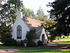 | February 13, 1979 (#79000510) | CA 29 38°23′31″N 122°21′50″W / 38.391944°N 122.363889°W / 38.391944; -122.363889 (Veterans Home of California Chapel) | Yountville | |
| 81 | John Lee Webber House | 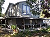 | January 19, 1982 (#82002219) | 6610 Webber St. 38°24′16″N 122°21′46″W / 38.404444°N 122.362778°W / 38.404444; -122.362778 (John Lee Webber House) | Yountville | Now the Lavender Bed and Breakfast |
| 82 | J.C. Weinberger Winery | 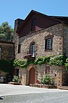 | April 6, 2015 (#15000124) | 2849 St. Helena Hwy. 38°31′06″N 122°29′25″W / 38.5182°N 122.4903°W / 38.5182; -122.4903 (J.C. Weinberger Winery) | St. Helena | Now the William Cole Vineyard |
| 83 | William Tell Saloon and Hotel | 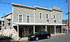 | May 7, 1982 (#82002217) | 1228 Spring St. 38°30′13″N 122°28′03″W / 38.503611°N 122.4675°W / 38.503611; -122.4675 (William Tell Saloon and Hotel) | St. Helena | |
| 84 | Winship-Smernes Building | 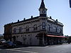 | July 29, 1977 (#77000317) | 948 Main St. 38°17′57″N 122°17′02″W / 38.299167°N 122.283889°W / 38.299167; -122.283889 (Winship-Smernes Building) | Napa | |
| 85 | Capt. N. H. Wulff House |  | August 18, 1992 (#92000994) | 549 Brown St. 38°17′41″N 122°16′56″W / 38.294722°N 122.282222°W / 38.294722; -122.282222 (Capt. N. H. Wulff House) | Napa | |
| 86 | York House | Upload image | May 3, 2016 (#16000209) | 1005 Jefferson St. 38°17′52″N 122°17′37″W / 38.297642°N 122.293546°W / 38.297642; -122.293546 (York House) | Napa | |
| 87 | Eliza G. Yount House |  | September 24, 1992 (#92001279) | 423 Seminary St. 38°17′29″N 122°17′28″W / 38.291389°N 122.291111°W / 38.291389; -122.291111 (Eliza G. Yount House) | Napa | |
| 88 | Yountville Grammar School | Upload image | June 14, 2016 (#16000356) | 6550 Yount St. 38°24′13″N 122°21′43″W / 38.403552°N 122.361806°W / 38.403552; -122.361806 (Yountville Grammar School) | Yountville |
Former listing
| [3] | Name on the Register | Image | Date listed | Date removed | Location | City or town | Description |
|---|---|---|---|---|---|---|---|
| 1 | Behlow Building |  | October 25, 1973 (#73002251) | February 17, 1977 | 2nd and Brown Sts. | Napa | Demolished in 1977.[11] |
See also
Wikimedia Commons has media related to National Register of Historic Places in Napa County, California.
- List of National Historic Landmarks in California
- National Register of Historic Places listings in California
- California Historical Landmarks in Napa County, California
References
- ^ The latitude and longitude information provided in this table was derived originally from the National Register Information System, which has been found to be fairly accurate for about 99% of listings. Some locations in this table may have been corrected to current GPS standards.
- ^ National Park Service, United States Department of the Interior, "National Register of Historic Places: Weekly List Actions", retrieved April 19, 2024.
- ^ a b Numbers represent an alphabetical ordering by significant words. Various colorings, defined here, differentiate National Historic Landmarks and historic districts from other NRHP buildings, structures, sites or objects.
- ^ "National Register Information System". National Register of Historic Places. National Park Service. July 9, 2010.
- ^ The eight-digit number below each date is the number assigned to each location in the National Register Information System database, which can be viewed by clicking the number.
- ^ Waters, John Jr. (January 14, 2008). "Dusting off an old jewel at Calistoga hospital". Napa Valley Register. Napa, California. Retrieved October 29, 2011.
- ^ Yerger, Rebecca (September 5, 2009). "Greystone Cellars". Napa Valley Register. Napa, California. Retrieved December 8, 2011.
- ^ Brennan, Nancy (October 17, 2010). "Examining the life of one of Napa's founding physicians". Napa Valley Register. Napa, California. Retrieved November 3, 2011.
- ^ Bender, Henry E. Jr. (2013). Southern Pacific Lines Standard-Design Depots. Berkeley and Wilton, California: Signature Press. p. 113. ISBN 9781930013339.
- ^ Yerger, Rebecca (June 10, 2011). "Napa's Williams Smith house preserved and restored". Napa Valley Register. Napa, California. Retrieved December 8, 2011.
- ^ Weber, Lin. Napa. p. 63. ISBN 0738529516.
- v
- t
- e
- List of U.S. National Historic Landmarks by state:
- Alabama
- Alaska
- Arizona
- Arkansas
- California
- Colorado
- Connecticut
- Delaware
- Florida
- Georgia
- Hawaii
- Idaho
- Illinois
- Indiana
- Iowa
- Kansas
- Kentucky
- Louisiana
- Maine
- Maryland
- Massachusetts
- Michigan
- Minnesota
- Mississippi
- Missouri
- Montana
- Nebraska
- Nevada
- New Hampshire
- New Jersey
- New Mexico
- New York
- North Carolina
- North Dakota
- Ohio
- Oklahoma
- Oregon
- Pennsylvania
- Rhode Island
- South Carolina
- South Dakota
- Tennessee
- Texas
- Utah
- Vermont
- Virginia
- Washington
- West Virginia
- Wisconsin
- Wyoming
 National Register of Historic Places portal
 Category


Municipalities and communities of Napa County, California, United States | ||
|---|---|---|
County seat: Napa | ||
| Cities and towns |  | |
| CDPs | ||
| Unincorporated communities | ||
| Ghost towns | ||
| ||


