National Register of Historic Places listings in Sherborn, Massachusetts
This is a list of properties and historic districts listed on the National Register of Historic Places in Sherborn, Massachusetts.
Map all coordinates using OpenStreetMap
Download coordinates as:
- KML
- GPX (all coordinates)
- GPX (primary coordinates)
- GPX (secondary coordinates)
The locations of National Register properties and districts (at least for all showing latitude and longitude coordinates below) may be seen in a Google map by clicking on "Map of all coordinates".[1]
This National Park Service list is complete through NPS recent listings posted April 12, 2024.[2]
Current listings
| [3] | Name on the Register | Image | Date listed[4] | Location | City or town | Description |
|---|---|---|---|---|---|---|
| 1 | Assington | 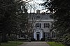 | January 3, 1986 (#86000490) | 172 Forest St. 42°13′41″N 71°20′30″W / 42.228056°N 71.341667°W / 42.228056; -71.341667 (Assington) | ||
| 2 | Bullen–Stratton–Cozzen House |  | January 3, 1986 (#86000496) | 52 Brush Hill Rd. 42°15′15″N 71°24′06″W / 42.254167°N 71.401667°W / 42.254167; -71.401667 (Bullen–Stratton–Cozzen House) | ||
| 3 | Clark–Northrup House |  | January 3, 1986 (#86000497) | 93 Maple St. 42°14′19″N 71°23′14″W / 42.238611°N 71.387222°W / 42.238611; -71.387222 (Clark–Northrup House) | ||
| 4 | Joseph Cleale House | 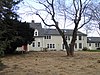 | January 3, 1986 (#86000498) | 147 Western Ave. 42°14′21″N 71°24′23″W / 42.239167°N 71.406389°W / 42.239167; -71.406389 (Joseph Cleale House) | ||
| 5 | Rev. Edmund Dowse House |  | January 3, 1986 (#86000499) | 25 Farm Rd. 42°14′19″N 71°21′55″W / 42.238611°N 71.365278°W / 42.238611; -71.365278 (Rev. Edmund Dowse House) | ||
| 6 | Edward's Plain–Dowse's Corner Historic District |  | January 3, 1986 (#86000492) | N. Main St. between Eliot and Everett Sts. 42°15′11″N 71°22′06″W / 42.253056°N 71.368333°W / 42.253056; -71.368333 (Edward's Plain–Dowse's Corner Historic District) | ||
| 7 | Thomas Fleming House |  | January 3, 1986 (#86000500) | 18 Maple St. 42°14′28″N 71°22′29″W / 42.241111°N 71.374722°W / 42.241111; -71.374722 (Thomas Fleming House) | ||
| 8 | Addington Gardner House |  | March 9, 1990 (#90000179) | 128 Hollis St. 42°12′58″N 71°23′55″W / 42.216111°N 71.398611°W / 42.216111; -71.398611 (Addington Gardner House) | ||
| 9 | Eleazer Goulding House |  | January 3, 1986 (#86000501) | 137 Western Ave. 42°14′27″N 71°24′24″W / 42.240833°N 71.406667°W / 42.240833; -71.406667 (Eleazer Goulding House) | ||
| 10 | Charles Holbrook House | 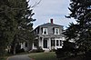 | January 3, 1986 (#86000502) | 137 S. Main St. 42°13′31″N 71°21′47″W / 42.225278°N 71.363056°W / 42.225278; -71.363056 (Charles Holbrook House) | ||
| 11 | Deacon William Leland House | 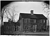 | January 3, 1986 (#86000503) | 27 Hollis St. 42°12′29″N 71°23′05″W / 42.207962°N 71.384714°W / 42.207962; -71.384714 (Deacon William Leland House) | ||
| 12 | Charles D. Lewis House |  | January 3, 1986 (#86000504) | 81 Hunting Ln. 42°14′58″N 71°23′00″W / 42.249444°N 71.383333°W / 42.249444; -71.383333 (Charles D. Lewis House) | ||
| 13 | Daniel Morse III House |  | January 3, 1986 (#86000505) | 210 Farm Rd. 42°14′05″N 71°20′13″W / 42.234722°N 71.336944°W / 42.234722; -71.336944 (Daniel Morse III House) | ||
| 14 | Morse–Barber House |  | January 3, 1986 (#86000493) | 46 Forest St. 42°13′14″N 71°21′23″W / 42.220556°N 71.356389°W / 42.220556; -71.356389 (Morse–Barber House) | ||
| 15 | Morse–Tay–Leland–Hawes House |  | January 3, 1986 (#86000506) | 266 Western Ave. 42°13′24″N 71°24′03″W / 42.223333°N 71.400833°W / 42.223333; -71.400833 (Morse–Tay–Leland–Hawes House) | ||
| 16 | Asa Sanger House |  | January 3, 1986 (#86000507) | 70 Washington St. 42°14′08″N 71°22′52″W / 42.235556°N 71.381111°W / 42.235556; -71.381111 (Asa Sanger House) | ||
| 17 | Richard Sanger III House |  | January 3, 1986 (#86000508) | 60 Washington St. 42°14′09″N 71°22′48″W / 42.235833°N 71.38°W / 42.235833; -71.38 (Richard Sanger III House) | ||
| 18 | Sawin–Bullen–Bullard House |  | January 3, 1986 (#86000509) | 60 Brush Hill Rd. 42°15′27″N 71°24′15″W / 42.2575°N 71.404167°W / 42.2575; -71.404167 (Sawin–Bullen–Bullard House) | ||
| 19 | Sewall–Ware House | Upload image | January 3, 1986 (#86000494) | 100 S. Main St. 42°13′43″N 71°22′02″W / 42.228611°N 71.367222°W / 42.228611; -71.367222 (Sewall–Ware House) | ||
| 20 | Sherborn Center Historic District | 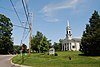 | January 3, 1986 (#86000495) | Roughly bounded by Zion's Ln., Conrail railroad tracks, Farm and Sawin Sts., and Washington and N. Main Sts. 42°14′30″N 71°22′16″W / 42.241667°N 71.371111°W / 42.241667; -71.371111 (Sherborn Center Historic District) | ||
| 21 | Sudbury Aqueduct Linear District | 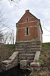 | January 18, 1990 (#89002293) | Along Sudbury Aqueduct from Farm Pond at Waverly St. (Framingham) to Chestnut Hill Reservoir (Newton) 42°16′09″N 71°22′56″W / 42.269052°N 71.382136°W / 42.269052; -71.382136 (Sudbury Aqueduct Linear District) | Extends from Framingham to Newton. | |
| 22 | Joseph Twitchell House |  | January 3, 1986 (#86000510) | 32 Pleasant St. 42°13′55″N 71°24′06″W / 42.231944°N 71.401667°W / 42.231944; -71.401667 (Joseph Twitchell House) | ||
| 23 | H. G. Vaughn House |  | January 3, 1986 (#86000511) | 5 Sparhawk Rd. 42°12′24″N 71°22′09″W / 42.206667°N 71.369167°W / 42.206667; -71.369167 (H. G. Vaughn House) | ||
| 24 | Ware's Tavern | 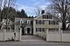 | January 3, 1986 (#86000512) | 113 S. Main St. 42°13′39″N 71°21′58″W / 42.2275°N 71.366111°W / 42.2275; -71.366111 (Ware's Tavern) | ||
| 25 | Woodland Farm–Leland House |  | January 3, 1986 (#86000513) | 104 Woodland St. 42°13′19″N 71°22′54″W / 42.221944°N 71.381667°W / 42.221944; -71.381667 (Woodland Farm–Leland House) |
References
Wikimedia Commons has media related to National Register of Historic Places in Sherborn, Massachusetts.
- ^ The latitude and longitude information provided in this table was derived originally from the National Register Information System, which has been found to be fairly accurate for about 99% of listings. Some locations in this table may have been corrected to current GPS standards.
- ^ National Park Service, United States Department of the Interior, "National Register of Historic Places: Weekly List Actions", retrieved April 12, 2024.
- ^ Numbers represent an alphabetical ordering by significant words. Various colorings, defined here, differentiate National Historic Landmarks and historic districts from other NRHP buildings, structures, sites or objects.
- ^ The eight-digit number below each date is the number assigned to each location in the National Register Information System database, which can be viewed by clicking the number.
- v
- t
- e
- List of U.S. National Historic Landmarks by state:
- Alabama
- Alaska
- Arizona
- Arkansas
- California
- Colorado
- Connecticut
- Delaware
- Florida
- Georgia
- Hawaii
- Idaho
- Illinois
- Indiana
- Iowa
- Kansas
- Kentucky
- Louisiana
- Maine
- Maryland
- Massachusetts
- Michigan
- Minnesota
- Mississippi
- Missouri
- Montana
- Nebraska
- Nevada
- New Hampshire
- New Jersey
- New Mexico
- New York
- North Carolina
- North Dakota
- Ohio
- Oklahoma
- Oregon
- Pennsylvania
- Rhode Island
- South Carolina
- South Dakota
- Tennessee
- Texas
- Utah
- Vermont
- Virginia
- Washington
- West Virginia
- Wisconsin
- Wyoming
 National Register of Historic Places portal
 Category


