National Register of Historic Places listings in West Hartford, Connecticut

This is a list of the National Register of Historic Places listings in West Hartford, Connecticut.
This is intended to be a complete list of the properties and districts on the National Register of Historic Places in West Hartford, Connecticut, United States. The locations of National Register properties and districts for which the latitude and longitude coordinates are included below, may be seen in various online maps.[1]
There are more than 400 properties and districts listed on the National Register in Hartford County, including 21 National Historic Landmarks. The 32 properties and districts located in the town of West Hartford include two National Historic Landmarks and are listed below. The properties and districts in the remaining parts of the county are listed separately. Six properties and districts straddle the border between West Hartford and Hartford and appear in both lists.
| Fairfield (city of Bridgeport) (town of Greenwich) (city of Stamford) | Hartford (city of Hartford) (town of Southington) (town of West Hartford) (town of Windsor) | Litchfield | Middlesex (city of Middletown) | New Haven (city of New Haven) | New London | Tolland | Windham |
This National Park Service list is complete through NPS recent listings posted September 13, 2024.[2]
Map all coordinates using OpenStreetMap
Download coordinates as:
- KML
- GPX (all coordinates)
- GPX (primary coordinates)
- GPX (secondary coordinates)
Current listings
| [3] | Name on the Register[4] | Image | Date listed[5] | Location | City or town | Description |
|---|---|---|---|---|---|---|
| 1 | Charles E. Beach House |  | August 23, 1990 (#90001287) | 18 Brightwood Ln. 41°43′58″N 72°44′31″W / 41.732760°N 72.741872°W / 41.732760; -72.741872 (Charles E. Beach House) | ||
| 2 | Beardsley-Mix House |  | September 10, 1986 (#86001980) | 81 Rockledge Dr. 41°44′41″N 72°44′38″W / 41.744623°N 72.744016°W / 41.744623; -72.744016 (Beardsley-Mix House) | ||
| 3 | Moses Brace-Uriah Cadwell House |  | September 10, 1986 (#86001982) | 11 Flagg Rd. 41°47′06″N 72°45′00″W / 41.785°N 72.75°W / 41.785; -72.75 (Moses Brace-Uriah Cadwell House) | ||
| 4 | James Butler House | 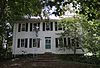 | September 10, 1986 (#86001987) | 239 N. Main St. 41°46′40″N 72°44′48″W / 41.777778°N 72.746667°W / 41.777778; -72.746667 (James Butler House) | ||
| 5 | Benjamin Colton House |  | September 10, 1986 (#86001988) | 25 Sedgewick Rd. 41°45′09″N 72°44′45″W / 41.752450°N 72.745811°W / 41.752450; -72.745811 (Benjamin Colton House) | ||
| 6 | Elizabeth Park |  | March 10, 1983 (#83001259) | Asylum Ave. 41°46′20″N 72°43′04″W / 41.772222°N 72.717778°W / 41.772222; -72.717778 (Elizabeth Park) | Extends into Hartford | |
| 7 | Samuel Farnsworth House |  | September 10, 1986 (#86001990) | 537 Mountain Rd. 41°46′50″N 72°45′59″W / 41.780556°N 72.766389°W / 41.780556; -72.766389 (Samuel Farnsworth House) | ||
| 8 | Asa Gillett House | 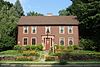 | September 10, 1986 (#86001992) | 202 S. Main St. 41°44′55″N 72°44′48″W / 41.748611°N 72.746667°W / 41.748611; -72.746667 (Asa Gillett House) | ||
| 9 | Timothy Goodman House |  | September 10, 1986 (#86001993) | 567 Quaker Ln., S. 41°44′42″N 72°43′50″W / 41.745°N 72.730556°W / 41.745; -72.730556 (Timothy Goodman House) | ||
| 10 | Hartford Golf Club Historic District |  | June 26, 1986 (#86001370) | Roughly bounded by Simsbury Rd. and Bloomfield Ave., Northmoor Rd., Albany Ave., and Mohegan Dr. 41°47′33″N 72°43′31″W / 41.7925°N 72.725278°W / 41.7925; -72.725278 (Hartford Golf Club Historic District) | Extends into Hartford | |
| 11 | Sarah Whitman Hooker House | 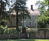 | November 1, 1979 (#79002627) | 1237 New Britain Ave. 41°43′53″N 72°44′35″W / 41.731389°N 72.743056°W / 41.731389; -72.743056 (Sarah Whitman Hooker House) | ||
| 12 | Daniel Hosmer House |  | September 10, 1986 (#86001985) | 253 N. Main St. 41°46′44″N 72°44′50″W / 41.778889°N 72.747222°W / 41.778889; -72.747222 (Daniel Hosmer House) | ||
| 13 | House at 847 Main Street, North |  | September 10, 1986 (#86001996) | 847 Main St., N. 41°47′26″N 72°44′52″W / 41.790556°N 72.747778°W / 41.790556; -72.747778 (House at 847 Main Street, North) | ||
| 14 | Edward W. Morley House | 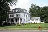 | May 15, 1975 (#75002057) | 26 Westland Ave. 41°45′21″N 72°45′36″W / 41.755833°N 72.76°W / 41.755833; -72.76 (Edward W. Morley House) | Home of the scientist known for the Michelson–Morley experiment and for his work on the atomic weights of hydrogen and oxygen. | |
| 15 | Mount St. Joseph Academy |  | December 22, 1983 (#83003561) | 235 Fern St. 41°46′05″N 72°43′26″W / 41.768056°N 72.723889°W / 41.768056; -72.723889 (Mount St. Joseph Academy) | ||
| 16 | Old Center Burying Yard | 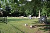 | May 3, 2002 (#02000421) | 30 N. Main St. 41°45′58″N 72°44′30″W / 41.766111°N 72.741667°W / 41.766111; -72.741667 (Old Center Burying Yard) | ||
| 17 | Prospect Avenue Historic District |  | August 29, 1985 (#85001918) | Roughly bounded by Albany Ave., N. Branch Park River, Elizabeth and Fern Sts., Prospect and Asylum Aves., and Sycamore Rd. 41°46′43″N 72°42′38″W / 41.778611°N 72.710556°W / 41.778611; -72.710556 (Prospect Avenue Historic District) | Extends into Hartford | |
| 18 | Revolutionary War Campsite |  | April 24, 1986 (#86000853) | On the grounds of MDC Reservoir #6 41°47′40″N 72°46′46″W / 41.794377°N 72.779359°W / 41.794377; -72.779359 (Revolutionary War Campsite) | A Revolutionary War campsite and military hospital.[6] | |
| 19 | Elisha Seymour Jr. House |  | September 10, 1986 (#86001997) | 410 and 412 Park Rd. 41°45′19″N 72°44′00″W / 41.755278°N 72.733333°W / 41.755278; -72.733333 (Elisha Seymour Jr. House) | ||
| 20 | The Spanish House | 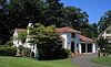 | June 14, 1979 (#79002632) | 46 Fernwood Rd. 41°46′16″N 72°43′28″W / 41.771111°N 72.724444°W / 41.771111; -72.724444 (The Spanish House) | ||
| 21 | Stanley-Woodruff-Allen House |  | September 10, 1986 (#86002000) | 37 Buena Vista Rd. 41°44′58″N 72°46′00″W / 41.749444°N 72.766667°W / 41.749444; -72.766667 (Stanley-Woodruff-Allen House) | ||
| 22 | Allyn Steele House |  | September 10, 1986 (#86002022) | 114 N. Main St. 41°46′11″N 72°44′37″W / 41.769722°N 72.743611°W / 41.769722; -72.743611 (Allyn Steele House) | ||
| 23 | Temple Beth Israel | 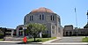 | November 27, 1995 (#95001343) | 701 Farmington Ave. 41°45′53″N 72°43′12″W / 41.764722°N 72.72°W / 41.764722; -72.72 (Temple Beth Israel) | ||
| 24 | Watkinson Juvenile Asylum and Farm School |  | March 23, 1995 (#95000273) | 140, 180 and 190 Bloomfield Ave. 41°47′24″N 72°42′45″W / 41.79°N 72.7125°W / 41.79; -72.7125 (Watkinson Juvenile Asylum and Farm School) | Extends into Hartford; now known as the Watkinson School. | |
| 25 | Noah Webster Birthplace |  | October 15, 1966 (#66000886) | 227 S. Main St. 41°44′46″N 72°44′47″W / 41.746111°N 72.746389°W / 41.746111; -72.746389 (Noah Webster Birthplace) | Home of the American lexicographer. | |
| 26 | Noah Webster Memorial Library |  | July 30, 1981 (#81000534) | 7 N. Main St. 41°45′41″N 72°43′07″W / 41.761389°N 72.718611°W / 41.761389; -72.718611 (Noah Webster Memorial Library) | ||
| 27 | John Wells Jr. House | 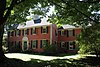 | September 10, 1986 (#86002025) | 505 Mountain Rd. 41°46′42″N 72°45′59″W / 41.778333°N 72.766389°W / 41.778333; -72.766389 (John Wells Jr. House) | ||
| 28 | West End North Historic District |  | July 25, 1985 (#85001618) | Roughly bounded by Farmington Ave., Lorraine, Elizabeth, and Highland Sts. 41°46′09″N 72°42′44″W / 41.769167°N 72.712222°W / 41.769167; -72.712222 (West End North Historic District) | Extends into Hartford | |
| 29 | West End South Historic District |  | April 11, 1985 (#85000763) | Roughly bounded by Farmington Ave., Whitney and S. Whitney Sts., West Boulevard, and Prospect Ave. 41°45′47″N 72°42′52″W / 41.763056°N 72.714444°W / 41.763056; -72.714444 (West End South Historic District) | Extends into Hartford | |
| 30 | West Hill Historic District |  | November 29, 1996 (#96001366) | West Hill Dr. bounded by Farmington Ave. 41°45′59″N 72°43′28″W / 41.766389°N 72.724444°W / 41.766389; -72.724444 (West Hill Historic District) | ||
| 31 | Whiting Homestead |  | August 3, 1987 (#87001291) | 291 N. Main St. 41°46′50″N 72°44′50″W / 41.780556°N 72.747222°W / 41.780556; -72.747222 (Whiting Homestead) | ||
| 32 | Whitman House |  | September 10, 1986 (#86002028) | 208 N. Main St. 41°46′33″N 72°44′43″W / 41.775833°N 72.745278°W / 41.775833; -72.745278 (Whitman House) |
See also
Wikimedia Commons has media related to National Register of Historic Places in West Hartford, Connecticut.
- List of National Historic Landmarks in Connecticut
- National Register of Historic Places listings in Connecticut
References
- ^ The latitude and longitude information provided in this table was derived originally from the National Register Information System, which has been found to be fairly accurate for about 99% of listings. Some locations in this table may have been corrected to current GPS standards.
- ^ National Park Service, United States Department of the Interior, "National Register of Historic Places: Weekly List Actions", retrieved September 13, 2024.
- ^ Numbers represent an alphabetical ordering by significant words. Various colorings, defined here, differentiate National Historic Landmarks and historic districts from other NRHP buildings, structures, sites or objects.
- ^ "National Register Information System". National Register of Historic Places. National Park Service. March 13, 2009.
- ^ The eight-digit number below each date is the number assigned to each location in the National Register Information System database, which can be viewed by clicking the number.
- ^ Marlene Clark (August 1, 2007). "Campsite Not Related To Rochambeau's Trek Through State / SINCE YOU ASKED: WEST HARTFORD". Hartford Courant.
- v
- t
- e

- Bridgeport
- Greenwich
- Hartford
- Middletown
- New Haven
- Southington
- Stamford
- West Hartford
- Windsor


