National Register of Historic Places listings in Wyoming County, New York

Map all coordinates using OpenStreetMap
Download coordinates as:
- KML
- GPX (all coordinates)
- GPX (primary coordinates)
- GPX (secondary coordinates)
List of the National Register of Historic Places listings in Wyoming County, New York
This is intended to be a complete list of properties and districts listed on the National Register of Historic Places in Wyoming County, New York. The locations of National Register properties and districts (at least for all showing latitude and longitude coordinates below) may be seen in a map by clicking on "Map of all coordinates".[1]
This National Park Service list is complete through NPS recent listings posted April 5, 2024.[2]
| Albany (Albany) – Allegany – Bronx – Broome – Cattaraugus – Cayuga – Chautauqua – Chemung – Chenango – Clinton – Columbia – Cortland – Delaware – Dutchess (Poughkeepsie, Rhinebeck) – Erie (Buffalo) – Essex – Franklin – Fulton – Genesee – Greene – Hamilton – Herkimer – Jefferson – Kings – Lewis – Livingston – Madison – Monroe (Rochester) – Montgomery – Nassau – New York (Below 14th Street, 14th to 59th Streets, 59th to 110th Streets, Above 110th Street, Islands) – Niagara (Niagara Falls) – Oneida – Onondaga (Syracuse) – Ontario – Orange – Orleans – Oswego – Otsego – Putnam – Queens – Rensselaer – Richmond – Rockland – St. Lawrence – Saratoga – Schenectady – Schoharie – Schuyler – Seneca – Steuben – Suffolk – Sullivan – Tioga – Tompkins – Ulster – Warren – Washington – Wayne – Westchester (Northern, Southern, New Rochelle, Peekskill, Yonkers) – Wyoming – Yates |
Listings county-wide
| [3] | Name on the Register | Image | Date listed[4] | Location | City or town | Description |
|---|---|---|---|---|---|---|
| 1 | Arcade and Attica Railroad |  | November 17, 1980 (#80002797) | Railroad right of way from Arcade to N. Java 42°34′24″N 78°25′22″W / 42.573333°N 78.422778°W / 42.573333; -78.422778 (Arcade and Attica Railroad) | North Java | |
| 2 | Arcade Center Farm | Upload image | April 15, 2004 (#04000290) | 7298 NY 98 42°32′38″N 78°24′12″W / 42.543889°N 78.403333°W / 42.543889; -78.403333 (Arcade Center Farm) | Arcade | |
| 3 | Attica Market and Main Historic District |  | May 1, 2013 (#13000225) | 2-28 & 19-45 Market St., 2-10 & 21-39 Main St. 42°51′55″N 78°17′05″W / 42.865196°N 78.284663°W / 42.865196; -78.284663 (Attica Market and Main Historic District) | Attica | |
| 4 | Brick Presbyterian Church | 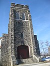 | October 3, 2007 (#07001042) | 6 Church St. 42°43′15″N 78°00′05″W / 42.720833°N 78.001317°W / 42.720833; -78.001317 (Brick Presbyterian Church) | Perry | |
| 5 | Epworth Hall |  | April 6, 2000 (#00000350) | Perry Ave. 42°41′53″N 78°01′16″W / 42.698056°N 78.021111°W / 42.698056; -78.021111 (Epworth Hall) | Perry | |
| 6 | Exchange Street Historic District |  | November 21, 2012 (#12000962) | 15-48 Exchange St. & Erie RR Depot 42°51′48″N 78°16′50″W / 42.863226°N 78.280486°W / 42.863226; -78.280486 (Exchange Street Historic District) | Attica | |
| 7 | First Free Will Baptist Church of Pike | 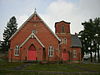 | June 27, 2012 (#12000369) | 72 Main St. 42°33′17″N 78°09′21″W / 42.554614°N 78.155839°W / 42.554614; -78.155839 (First Free Will Baptist Church of Pike) | Pike | |
| 8 | First Methodist Episcopal Church of Perry |  | September 28, 2006 (#06000880) | 35 Covington St. 42°43′10″N 78°00′18″W / 42.719444°N 78.005°W / 42.719444; -78.005 (First Methodist Episcopal Church of Perry) | Perry | |
| 9 | First Universalist Church of Portageville |  | February 19, 2008 (#08000040) | E. Koy Rd. at NY 19A 42°34′04″N 78°02′43″W / 42.567778°N 78.045278°W / 42.567778; -78.045278 (First Universalist Church of Portageville) | Portageville | |
| 10 | Bryant Fleming House |  | October 14, 2009 (#09000838) | 1024 Tower Road 42°49′52″N 78°05′31″W / 42.831219°N 78.091872°W / 42.831219; -78.091872 (Bryant Fleming House) | Wyoming | |
| 11 | Seth M. Gates House |  | February 21, 1992 (#92000031) | 15 Perry Ave. 42°44′26″N 78°08′06″W / 42.740556°N 78.135°W / 42.740556; -78.135 (Seth M. Gates House) | Warsaw | |
| 12 | Java School No. 1 | Upload image | June 21, 2001 (#01000672) | NY 78 42°40′26″N 78°26′11″W / 42.673889°N 78.436389°W / 42.673889; -78.436389 (Java School No. 1) | Java Village | |
| 13 | Letchworth State Park |  | November 4, 2005 (#03000718) | Genesee River Gorge Bet. Portageville and Mt. Morris 42°38′05″N 77°59′00″W / 42.634722°N 77.983333°W / 42.634722; -77.983333 (Letchworth State Park) | Castile | |
| 14 | Middlebury Academy |  | January 17, 1973 (#73001293) | 22 S. Academy St. 42°49′39″N 78°05′23″W / 42.8275°N 78.089722°W / 42.8275; -78.089722 (Middlebury Academy) | Wyoming | |
| 15 | Monument Circle Historic District |  | May 11, 1992 (#92000447) | Roughly, E. Court St. from N. Main St. to Park St. and adjacent parts of Main and Park 42°44′35″N 78°07′53″W / 42.743056°N 78.131389°W / 42.743056; -78.131389 (Monument Circle Historic District) | Warsaw | |
| 16 | Perry Downtown Historic District |  | April 16, 2012 (#12000212) | N. & S. Main, Covington, & Lake Sts., Borden Ave. 42°43′06″N 78°00′07″W / 42.718421°N 78.002052°W / 42.718421; -78.002052 (Perry Downtown Historic District) | Perry | |
| 17 | Perry Village Hall | Upload image | October 28, 2022 (#100008318) | 46 North Main St. 42°43′10″N 78°00′03″W / 42.7194°N 78.0009°W / 42.7194; -78.0009 (Perry Village Hall) | Perry | |
| 18 | Barna C. Roup House | Upload image | August 10, 2015 (#15000519) | 38 Borden Ave. 42°43′02″N 78°00′12″W / 42.717333°N 78.0033056°W / 42.717333; -78.0033056 (Barna C. Roup House) | Perry | 1898 Queen Anne house built by notable local attorney during period of village's major growth |
| 19 | Silver Lake Institute Historic District | 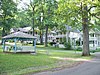 | September 19, 1985 (#85002442) | Roughly bounded by Wesley, Embury, Thompson, Haven, Lakeside & Lakeview Aves. 42°41′56″N 78°01′20″W / 42.698889°N 78.022222°W / 42.698889; -78.022222 (Silver Lake Institute Historic District) | Silver Lake | |
| 20 | Augustus A. Smith House |  | June 27, 2007 (#07000627) | 125 Main St. 42°51′44″N 78°16′42″W / 42.862236°N 78.278336°W / 42.862236; -78.278336 (Augustus A. Smith House) | Attica | |
| 21 | Trinity Church |  | March 18, 1980 (#80002798) | W. Buffalo St. 42°44′23″N 78°08′03″W / 42.739722°N 78.134167°W / 42.739722; -78.134167 (Trinity Church) | Warsaw | |
| 22 | US Post Office-Attica | 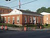 | November 17, 1988 (#88002453) | 76 Main St. 42°51′49″N 78°16′51″W / 42.863611°N 78.280833°W / 42.863611; -78.280833 (US Post Office-Attica) | Attica | |
| 23 | US Post Office-Warsaw | 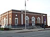 | May 11, 1989 (#88002441) | 35 S. Main St. 42°44′22″N 78°07′59″W / 42.739444°N 78.133056°W / 42.739444; -78.133056 (US Post Office-Warsaw) | Warsaw | |
| 24 | Warsaw Academy |  | January 3, 1980 (#80002799) | 73 S. Main St. 42°44′19″N 78°07′58″W / 42.738611°N 78.132778°W / 42.738611; -78.132778 (Warsaw Academy) | Warsaw | |
| 25 | Warsaw Downtown Historic District |  | November 21, 2012 (#12000963) | N. & S. Main between Frank & Brooklyn Sts. 42°44′22″N 78°07′57″W / 42.739424°N 78.132589°W / 42.739424; -78.132589 (Warsaw Downtown Historic District) | Warsaw | |
| 26 | Orator F. Woodward Cottage | Upload image | August 22, 2016 (#16000559) | 3931 Thompson Ave. 42°41′55″N 78°01′11″W / 42.6985495°N 78.0196654°W / 42.6985495; -78.0196654 (Orator F. Woodward Cottage) | Silver Lake | 1894 vacation home of Jell-O inventor and popularizer, later used as a guest house for Methodist preachers visiting the Silver Lake Institute |
| 27 | Wyoming Village Historic District |  | December 27, 1974 (#74001326) | NY 19 42°49′37″N 78°05′15″W / 42.826944°N 78.0875°W / 42.826944; -78.0875 (Wyoming Village Historic District) | Wyoming |
See also
Wikimedia Commons has media related to National Register of Historic Places in Wyoming County, New York.
References
- ^ The latitude and longitude information provided in this table was derived originally from the National Register Information System, which has been found to be fairly accurate for about 99% of listings. Some locations in this table may have been corrected to current GPS standards.
- ^ National Park Service, United States Department of the Interior, "National Register of Historic Places: Weekly List Actions", retrieved April 5, 2024.
- ^ Numbers represent an alphabetical ordering by significant words. Various colorings, defined here, differentiate National Historic Landmarks and historic districts from other NRHP buildings, structures, sites or objects.
- ^ The eight-digit number below each date is the number assigned to each location in the National Register Information System database, which can be viewed by clicking the number.
- v
- t
- e
U.S. National Register of Historic Places in New York

by county
- Albany
- Allegany
- Bronx
- Broome
- Cattaraugus
- Cayuga
- Chautauqua
- Chemung
- Chenango
- Clinton
- Columbia
- Cortland
- Delaware
- Dutchess
- Erie
- Essex
- Franklin
- Fulton
- Genesee
- Greene
- Hamilton
- Herkimer
- Jefferson
- Kings (Brooklyn)
- Lewis
- Livingston
- Madison
- Monroe
- Montgomery
- Nassau
- New York (Manhattan)
- Niagara
- Oneida
- Onondaga
- Ontario
- Orange
- Orleans
- Oswego
- Otsego
- Putnam
- Queens
- Rensselaer
- Richmond (Staten Island)
- Rockland
- Saratoga
- Schenectady
- Schoharie
- Schuyler
- Seneca
- St. Lawrence
- Steuben
- Suffolk
- Sullivan
- Tioga
- Tompkins
- Ulster
- Warren
- Washington
- Wayne
- Westchester
- Wyoming
- Yates
by city
 Category
 List
List National Register of Historic Places Portal


