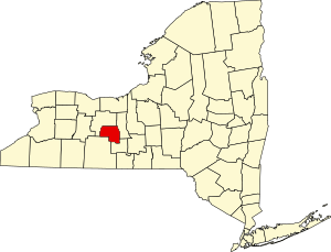
National Register of Historic Places listings in Yates County, New York
Map all coordinates using OpenStreetMap
Download coordinates as:
- KML
- GPX (all coordinates)
- GPX (primary coordinates)
- GPX (secondary coordinates)
List of the National Register of Historic Places listings in Yates County, New York
This is intended to be a complete list of properties and districts listed on the National Register of Historic Places in Yates County, New York. The locations of National Register properties and districts (at least for all showing latitude and longitude coordinates below) may be seen in a map by clicking on "Map of all coordinates".[1]
This National Park Service list is complete through NPS recent listings posted April 5, 2024.[2]
| Albany (Albany) – Allegany – Bronx – Broome – Cattaraugus – Cayuga – Chautauqua – Chemung – Chenango – Clinton – Columbia – Cortland – Delaware – Dutchess (Poughkeepsie, Rhinebeck) – Erie (Buffalo) – Essex – Franklin – Fulton – Genesee – Greene – Hamilton – Herkimer – Jefferson – Kings – Lewis – Livingston – Madison – Monroe (Rochester) – Montgomery – Nassau – New York (Below 14th Street, 14th to 59th Streets, 59th to 110th Streets, Above 110th Street, Islands) – Niagara (Niagara Falls) – Oneida – Onondaga (Syracuse) – Ontario – Orange – Orleans – Oswego – Otsego – Putnam – Queens – Rensselaer – Richmond – Rockland – St. Lawrence – Saratoga – Schenectady – Schoharie – Schuyler – Seneca – Steuben – Suffolk – Sullivan – Tioga – Tompkins – Ulster – Warren – Washington – Wayne – Westchester (Northern, Southern, New Rochelle, Peekskill, Yonkers) – Wyoming – Yates |
Listings county-wide
| [3] | Name on the Register | Image | Date listed[4] | Location | City or town | Description |
|---|---|---|---|---|---|---|
| 1 | Angus Cobblestone Farmhouse and Barn Complex | Upload image | May 11, 1992 (#92000439) | 612 NY 14 42°44′03″N 76°58′29″W / 42.734167°N 76.974722°W / 42.734167; -76.974722 (Angus Cobblestone Farmhouse and Barn Complex) | Benton | |
| 2 | Jonathan Bailey House | Upload image | August 24, 1994 (#94000926) | Bath Rd. 42°35′22″N 77°03′34″W / 42.589444°N 77.059444°W / 42.589444; -77.059444 (Jonathan Bailey House) | Milo | |
| 3 | Barden Cobblestone Farmhouse |  | May 11, 1992 (#92000435) | 2492 Ferguson Corners Rd. 42°45′16″N 77°04′26″W / 42.754444°N 77.073889°W / 42.754444; -77.073889 (Barden Cobblestone Farmhouse) | Benton | |
| 4 | Bates Cobblestone Farmhouse |  | May 11, 1992 (#92000436) | 5521 NY 364 42°45′34″N 77°16′25″W / 42.759444°N 77.273611°W / 42.759444; -77.273611 (Bates Cobblestone Farmhouse) | Middlesex | |
| 5 | Beddoe–Rose Family Cemetery | Upload image | November 19, 2014 (#14000939) | E. of W. Bluff Dr., Keuka Lake State Park 42°34′57″N 77°07′55″W / 42.58249341284871°N 77.13193645908692°W / 42.58249341284871; -77.13193645908692 (Beddoe–Rose Family Cemetery) | Jerusalem | Grave sites of family involved in early settlement of area |
| 6 | Peter Bitley House | Upload image | August 24, 1994 (#94000927) | W. Lake Rd. (NY Rt. 54A) 42°35′32″N 77°09′11″W / 42.592222°N 77.153056°W / 42.592222; -77.153056 (Peter Bitley House) | Jerusalem | |
| 7 | Thomas Bitley House | Upload image | August 24, 1994 (#94000928) | Lake St. 42°35′33″N 77°09′10″W / 42.5925°N 77.152778°W / 42.5925; -77.152778 (Thomas Bitley House) | Jerusalem | |
| 8 | Samuel Botsford House | Upload image | August 24, 1994 (#94000929) | County House Rd. 42°37′46″N 77°09′41″W / 42.629444°N 77.161389°W / 42.629444; -77.161389 (Samuel Botsford House) | Jerusalem | |
| 9 | John Briggs House | Upload image | August 24, 1994 (#94000930) | 2646 Himrod Rd. 42°38′07″N 77°00′01″W / 42.635278°N 77.000278°W / 42.635278; -77.000278 (John Briggs House) | Milo Center | |
| 10 | John Carr House | Upload image | August 24, 1994 (#94000931) | NY 245 42°41′46″N 77°16′40″W / 42.696111°N 77.277778°W / 42.696111; -77.277778 (John Carr House) | Middlesex | |
| 11 | Crooked Lake Outlet Historic District |  | January 19, 1996 (#95001545) | Along the Keuka Lake Outlet Trail, from Penn Yan to Dresden 42°40′37″N 76°57′49″W / 42.676944°N 76.963611°W / 42.676944; -76.963611 (Crooked Lake Outlet Historic District) | Penn Yan | |
| 12 | Thomas Bennett Curtis House | Upload image | August 24, 1994 (#94000932) | Shannon Corners Rd. 42°33′00″N 76°55′53″W / 42.55°N 76.931389°W / 42.55; -76.931389 (Thomas Bennett Curtis House) | Starkey | |
| 13 | Dundee Methodist Church |  | January 5, 2005 (#04001445) | 33 Water St. 42°31′35″N 76°58′36″W / 42.526389°N 76.976667°W / 42.526389; -76.976667 (Dundee Methodist Church) | Dundee | |
| 14 | Dundee Village Historic District | 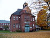 | April 10, 2007 (#07000329) | Main, Water, and Seneca Sts. 42°31′24″N 76°58′37″W / 42.523386°N 76.976872°W / 42.523386; -76.976872 (Dundee Village Historic District) | Dundee | |
| 15 | Jephtha Earl Cobblestone Farmhouse |  | May 11, 1992 (#92000438) | Old State Rd. N of jct. with Johnson Rd. 42°45′27″N 76°58′42″W / 42.7575°N 76.978333°W / 42.7575; -76.978333 (Jephtha Earl Cobblestone Farmhouse) | Benton | |
| 16 | Esperanza |  | December 7, 1995 (#95001406) | NY 54A E of Keuka Lake 42°35′45″N 77°08′06″W / 42.595833°N 77.135°W / 42.595833; -77.135 (Esperanza) | Jerusalem | |
| 17 | First Presbyterian Church |  | September 24, 2004 (#04001058) | 31 Main St. 42°31′28″N 76°58′37″W / 42.524444°N 76.976944°W / 42.524444; -76.976944 (First Presbyterian Church) | Dundee | |
| 18 | James Fox House | Upload image | August 24, 1994 (#94000934) | 750 Italy Valley Rd. 42°36′22″N 77°17′54″W / 42.606111°N 77.298333°W / 42.606111; -77.298333 (James Fox House) | Italy | |
| 19 | Garrett Memorial Chapel |  | March 30, 2001 (#01000296) | Skyline Dr. 42°30′27″N 77°07′54″W / 42.5075°N 77.131667°W / 42.5075; -77.131667 (Garrett Memorial Chapel) | Jerusalem | Norman Gothic chapel with scenic views of Keuka Lake |
| 20 | Asahel Green Farm | Upload image | August 24, 1994 (#94000935) | S. Vine Valley Rd. 42°43′40″N 77°18′00″W / 42.727778°N 77.3°W / 42.727778; -77.3 (Asahel Green Farm) | Middlesex | |
| 21 | Uriah Hair House | Upload image | August 24, 1994 (#94000936) | Water St. (Dundee-Himrod Rd.) 42°31′52″N 76°58′32″W / 42.531111°N 76.975556°W / 42.531111; -76.975556 (Uriah Hair House) | Dundee | |
| 22 | Hampstead | Upload image | August 24, 1994 (#94000937) | 3170 NY Rt. 54A 42°36′14″N 77°06′48″W / 42.603889°N 77.113333°W / 42.603889; -77.113333 (Hampstead) | Jerusalem | |
| 23 | Uriah Hanford House | Upload image | August 24, 1994 (#94000938) | W. Lake Rd. 42°39′12″N 77°04′35″W / 42.653333°N 77.076389°W / 42.653333; -77.076389 (Uriah Hanford House) | Jerusalem | |
| 24 | George Hays House | Upload image | August 24, 1994 (#94000939) | County House Rd. 42°40′01″N 77°04′26″W / 42.666944°N 77.073889°W / 42.666944; -77.073889 (George Hays House) | Jerusalem | |
| 25 | Himrod Baptist Church | Upload image | August 24, 1994 (#94000940) | Himrod Rd. 42°35′22″N 76°57′17″W / 42.589444°N 76.954722°W / 42.589444; -76.954722 (Himrod Baptist Church) | Milo | |
| 26 | James Hobart House | Upload image | August 24, 1994 (#94000941) | 4646 Italy Valley Rd. 42°41′39″N 77°12′47″W / 42.694167°N 77.213056°W / 42.694167; -77.213056 (James Hobart House) | Potter | |
| 27 | Robert Ingersoll Birthplace | 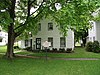 | February 11, 1988 (#88000110) | Main St. 42°41′02″N 76°57′23″W / 42.683889°N 76.956389°W / 42.683889; -76.956389 (Robert Ingersoll Birthplace) | Dresden | |
| 28 | Italy Valley Methodist Church | Upload image | August 24, 1994 (#94000942) | Italy Valley Rd. 42°36′39″N 77°17′32″W / 42.610833°N 77.292222°W / 42.610833; -77.292222 (Italy Valley Methodist Church) | Italy | |
| 29 | Lake View Cemetery |  | February 23, 1996 (#96000137) | W. Lake Rd. 42°39′41″N 77°03′51″W / 42.661389°N 77.064167°W / 42.661389; -77.064167 (Lake View Cemetery) | Penn Yan | |
| 30 | Larzelere Tavern | Upload image | December 19, 1997 (#97001525) | 3858 County House Rd. 42°37′36″N 77°09′45″W / 42.626667°N 77.1625°W / 42.626667; -77.1625 (Larzelere Tavern) | Branchport | |
| 31 | Smith McLoud House | Upload image | August 22, 1994 (#94000944) | Italy Tpk. 42°36′06″N 77°15′51″W / 42.601667°N 77.264167°W / 42.601667; -77.264167 (Smith McLoud House) | Italy | |
| 32 | Middlesex Center Methodist Church | Upload image | August 24, 1994 (#94000945) | Main St. 42°42′26″N 77°16′12″W / 42.707222°N 77.27°W / 42.707222; -77.27 (Middlesex Center Methodist Church) | Middlesex | |
| 33 | Roderick M. Morrison House |  | August 24, 1994 (#94000946) | 105 Highland Dr. 42°39′52″N 77°03′49″W / 42.664444°N 77.063611°W / 42.664444; -77.063611 (Roderick M. Morrison House) | Penn Yan | |
| 34 | William Nichols Cobblestone Farmhouse |  | May 11, 1992 (#92000437) | Alexander Rd. W of jct. with Thistle St. Rd. 42°45′33″N 77°02′21″W / 42.759167°N 77.039167°W / 42.759167; -77.039167 (William Nichols Cobblestone Farmhouse) | Benton | |
| 35 | John Noyes House | Upload image | August 24, 1994 (#94000947) | Lakemont-Himrod Rd. 42°31′19″N 76°55′33″W / 42.521944°N 76.925833°W / 42.521944; -76.925833 (John Noyes House) | Starkey | |
| 36 | Overackers Corners Schoolhouse |  | August 24, 1994 (#94000948) | Vine Valley Rd. 42°44′21″N 77°16′49″W / 42.739167°N 77.280278°W / 42.739167; -77.280278 (Overackers Corners Schoolhouse) | Middlesex | |
| 37 | Penn Yan Historic District |  | March 14, 1985 (#85000591) | Roughly bounded by Water, Seneca, Elm, Wagener, Court, Clinton, North and Main Sts. 42°39′49″N 77°03′08″W / 42.663611°N 77.052222°W / 42.663611; -77.052222 (Penn Yan Historic District) | Penn Yan | |
| 38 | Ezikial Perry House | Upload image | August 24, 1994 (#94000949) | 287 Sherman Hollow Rd. 42°40′01″N 77°05′57″W / 42.666944°N 77.099167°W / 42.666944; -77.099167 (Ezikial Perry House) | Jerusalem | |
| 39 | Arnold Potter House | Upload image | August 24, 1994 (#94000950) | 1445 Voak Rd. 42°41′22″N 77°07′44″W / 42.689444°N 77.128889°W / 42.689444; -77.128889 (Arnold Potter House) | Potter | |
| 40 | Miles Raplee House | Upload image | August 24, 1994 (#94000951) | Randall Rd. 42°37′03″N 76°55′25″W / 42.6175°N 76.923611°W / 42.6175; -76.923611 (Miles Raplee House) | Milo | |
| 41 | Sampson Theatre |  | November 7, 2008 (#08001035) | 130-136 E. Elm St. 42°39′41″N 77°03′08″W / 42.661511°N 77.052258°W / 42.661511; -77.052258 (Sampson Theatre) | Penn Yan | New listing; refnum# 08001035 |
| 42 | Sill Tenant House | Upload image | August 24, 1994 (#94000952) | 3232 Co. Rt. 54 42°36′08″N 77°07′18″W / 42.602222°N 77.121667°W / 42.602222; -77.121667 (Sill Tenant House) | Jerusalem | |
| 43 | Dr. Henry Spence Cobblestone Farmhouse and Barn Complex |  | May 11, 1992 (#92000441) | Lakemont-Himrod Rd. N of jct. with Shannon Corners Rd. 42°33′21″N 76°56′48″W / 42.555833°N 76.946667°W / 42.555833; -76.946667 (Dr. Henry Spence Cobblestone Farmhouse and Barn Complex) | Starkey | |
| 44 | Spicer-Millard House | Upload image | August 24, 1994 (#94000953) | Crystal Springs Rd. (NY 230) 42°30′03″N 77°02′43″W / 42.500833°N 77.045278°W / 42.500833; -77.045278 (Spicer-Millard House) | Barrington | |
| 45 | St. Luke's Episcopal Church | Upload image | August 24, 1994 (#94000954) | W. Lake Rd. (Co. Rt. 54A) 42°35′48″N 77°09′11″W / 42.596667°N 77.153056°W / 42.596667; -77.153056 (St. Luke's Episcopal Church) | Jerusalem | |
| 46 | Starkey United Methodist Church | Upload image | August 24, 1994 (#94000955) | Lakemont-Himrod Rd. 42°32′11″N 76°56′04″W / 42.536389°N 76.934444°W / 42.536389; -76.934444 (Starkey United Methodist Church) | Starkey | |
| 47 | Daniel Supplee Cobblestone Farmhouse | Upload image | May 11, 1992 (#92000442) | 4420 Dundee-Himrod Rd. 42°33′04″N 76°58′22″W / 42.551111°N 76.972778°W / 42.551111; -76.972778 (Daniel Supplee Cobblestone Farmhouse) | Starkey | |
| 48 | William Swarthout Farm | Upload image | August 24, 1994 (#94000956) | Bath Rd. 42°38′03″N 77°03′35″W / 42.634167°N 77.059722°W / 42.634167; -77.059722 (William Swarthout Farm) | Milo | |
| 49 | William Swortz House | Upload image | August 24, 1994 (#94000957) | Dundee-Himrod Rd. 42°32′53″N 76°58′24″W / 42.548056°N 76.973333°W / 42.548056; -76.973333 (William Swortz House) | Starkey | |
| 50 | US Post Office-Penn Yan |  | May 11, 1989 (#88002403) | 159 Main St. 42°39′44″N 77°03′16″W / 42.662222°N 77.054444°W / 42.662222; -77.054444 (US Post Office-Penn Yan) | Penn Yan | |
| 51 | Vine Valley Methodist Church | Upload image | August 24, 1994 (#94000958) | Robeson Rd. 42°43′26″N 77°19′29″W / 42.723889°N 77.324722°W / 42.723889; -77.324722 (Vine Valley Methodist Church) | Middlesex | |
| 52 | Abraham Wagener House |  | August 24, 1994 (#94000959) | Skyline Rd. 42°30′36″N 77°08′15″W / 42.51°N 77.1375°W / 42.51; -77.1375 (Abraham Wagener House) | Jerusalem | |
| 53 | Charles Wagener House |  | August 24, 1994 (#94000960) | 351 Elm St. 42°39′39″N 77°03′46″W / 42.660833°N 77.062778°W / 42.660833; -77.062778 (Charles Wagener House) | Penn Yan | |
| 54 | H. Allen Wagener House | Upload image | August 24, 1994 (#94000961) | 367 W. Lake Rd. 42°37′35″N 77°05′33″W / 42.626389°N 77.0925°W / 42.626389; -77.0925 (H. Allen Wagener House) | Jerusalem | |
| 55 | Myron Weaver House | Upload image | August 24, 1994 (#94000962) | 21 S. Main St. 42°35′39″N 77°09′17″W / 42.594167°N 77.154722°W / 42.594167; -77.154722 (Myron Weaver House) | Branchport | |
| 56 | Solomon Weaver House | Upload image | August 24, 1994 (#94000963) | 7 S. Main St. 42°35′53″N 77°09′22″W / 42.598056°N 77.156111°W / 42.598056; -77.156111 (Solomon Weaver House) | Branchport | |
| 57 | Whitaker House | Upload image | August 24, 1994 (#94000964) | Benton-Torrey Town Line Rd. 42°42′16″N 77°01′03″W / 42.704444°N 77.0175°W / 42.704444; -77.0175 (Whitaker House) | Benton | |
| 58 | Jemima Wilkinson House (Friend's Home) |  | August 24, 1994 (#94000965) | 3912 Friend Hill Rd. 42°39′12″N 77°09′54″W / 42.653333°N 77.165°W / 42.653333; -77.165 (Jemima Wilkinson House (Friend's Home)) | Jerusalem | |
| 59 | Sherman Williams House and Fruit Barn | Upload image | August 24, 1994 (#94000966) | Co. Rt. 54A 42°37′22″N 77°05′48″W / 42.622778°N 77.096667°W / 42.622778; -77.096667 (Sherman Williams House and Fruit Barn) | Jerusalem | |
| 60 | Christopher Willis House |  | August 24, 1994 (#94000967) | 57 Seneca St. 42°41′05″N 76°57′03″W / 42.684722°N 76.950833°W / 42.684722; -76.950833 (Christopher Willis House) | Dresden | |
| 61 | Milton Wilson House | Upload image | August 24, 1994 (#94000968) | 28 Gilbert St. 42°45′37″N 77°13′47″W / 42.760278°N 77.229722°W / 42.760278; -77.229722 (Milton Wilson House) | Rushville | |
| 62 | Abner Woodworth House | Upload image | August 24, 1994 (#94000969) | Flat St. 42°41′30″N 77°03′14″W / 42.691667°N 77.053889°W / 42.691667; -77.053889 (Abner Woodworth House) | Benton | |
| 63 | Dr. James Wrightman House | Upload image | August 24, 1994 (#94000970) | 48 W. Lake Rd. 42°35′28″N 77°09′04″W / 42.591111°N 77.151111°W / 42.591111; -77.151111 (Dr. James Wrightman House) | Branchport | |
| 64 | Yates County Courthouse Park District |  | June 19, 1979 (#79001652) | Main, Court and Liberty Sts. 42°39′54″N 77°03′28″W / 42.665°N 77.057778°W / 42.665; -77.057778 (Yates County Courthouse Park District) | Penn Yan | |
| 65 | Yatesville Methodist Church | Upload image | August 25, 1994 (#94000971) | Yatesville Rd. 42°40′18″N 77°08′16″W / 42.671667°N 77.137778°W / 42.671667; -77.137778 (Yatesville Methodist Church) | Potter | |
| 66 | Young-Leach Cobblestone Farmhouse and Barn Complex | Upload image | May 11, 1992 (#92000440) | 2601 NY 14 42°38′16″N 76°56′21″W / 42.637778°N 76.939167°W / 42.637778; -76.939167 (Young-Leach Cobblestone Farmhouse and Barn Complex) | Torrey |
See also
Wikimedia Commons has media related to National Register of Historic Places in Yates County, New York.
References
- ^ The latitude and longitude information provided in this table was derived originally from the National Register Information System, which has been found to be fairly accurate for about 99% of listings. Some locations in this table may have been corrected to current GPS standards.
- ^ National Park Service, United States Department of the Interior, "National Register of Historic Places: Weekly List Actions", retrieved April 5, 2024.
- ^ Numbers represent an alphabetical ordering by significant words. Various colorings, defined here, differentiate National Historic Landmarks and historic districts from other NRHP buildings, structures, sites or objects.
- ^ The eight-digit number below each date is the number assigned to each location in the National Register Information System database, which can be viewed by clicking the number.
- v
- t
- e
U.S. National Register of Historic Places in New York

by county
- Albany
- Allegany
- Bronx
- Broome
- Cattaraugus
- Cayuga
- Chautauqua
- Chemung
- Chenango
- Clinton
- Columbia
- Cortland
- Delaware
- Dutchess
- Erie
- Essex
- Franklin
- Fulton
- Genesee
- Greene
- Hamilton
- Herkimer
- Jefferson
- Kings (Brooklyn)
- Lewis
- Livingston
- Madison
- Monroe
- Montgomery
- Nassau
- New York (Manhattan)
- Niagara
- Oneida
- Onondaga
- Ontario
- Orange
- Orleans
- Oswego
- Otsego
- Putnam
- Queens
- Rensselaer
- Richmond (Staten Island)
- Rockland
- Saratoga
- Schenectady
- Schoharie
- Schuyler
- Seneca
- St. Lawrence
- Steuben
- Suffolk
- Sullivan
- Tioga
- Tompkins
- Ulster
- Warren
- Washington
- Wayne
- Westchester
- Wyoming
- Yates
by city
 Category
 List
List National Register of Historic Places Portal


