Omar, West Virginia
Census-designated place in West Virginia, United States
37°45′20″N 81°59′58″W / 37.75556°N 81.99944°W / 37.75556; -81.99944 (2010)[2]
25638
Omar is an unincorporated community and census-designated place (CDP) in Logan County, West Virginia, United States. Omar is located along West Virginia Route 44 and Island Creek, 6.5 miles (10.5 km) south of Logan.[4] Omar has a post office with ZIP code 25638.[5] As of the 2010 census, its population was 552.[2]
The community was named after James Omar Cole, one of the original lessors.[6]
-
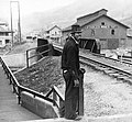 Omar in 1935

References
- ^ "2020 U.S. Gazetteer Files – West Virginia". United States Census Bureau. Retrieved March 17, 2021.
- ^ a b "Total Population: 2010 Census DEC Summary File 1 (P1), Omar CDP, West Virginia". data.census.gov. U.S. Census Bureau. Retrieved March 17, 2021.
- ^ U.S. Geological Survey Geographic Names Information System: Omar, West Virginia
- ^ West Virginia Atlas & Gazetteer. Yarmouth, Me.: DeLorme. 1997. p. 57. ISBN 0-89933-246-3.
- ^ ZIP Code Lookup
- ^ Swain, George T. "A History of the City of Logan, West Virginia: 1823-1916 (p. 117)". Retrieved March 6, 2022.
- v
- t
- e
Municipalities and communities of Logan County, West Virginia, United States
County seat: Logan

unincorporated
communities
- Aracoma
- Argyle
- Baber
- Baisden
- Banco
- Barnabus
- Becco
- Beebe
- Black Bottom
- Blair
- Bradshaw
- Braeholm
- Chambers
- Christian
- Claypool
- Coal Valley
- Combs Addition
- Cora
- Craneco
- Crites
- Crown
- Crystal Block
- Dabney
- Daisy
- Davin
- Davis
- Dehue
- Diamond
- Dobra
- Dog Patch
- Don
- Emmett
- Ethel
- Fanco
- Five Block
- Fort Branch
- Freeze Fork
- Frogtown
- Gillman Bottom
- Godby Heights
- Guyan Terrace
- Halcyon
- Hedgeview
- Hetzel
- Huff Junction
- Hutchinson
- Kelly
- Kitchen
- Lake
- Landville
- Latrobe
- Lintz Addition
- Logan Heights
- Lorado
- Lundale
- Lyburn
- Melville
- Micco
- Mifflin
- Mineral City
- Monclo
- Monitor
- Mountain View
- Oilville
- Orville
- Pardee
- Pecks Mill
- Phico
- Pine Creek
- Ralumco
- Red Campbell
- Ridgeview
- Rita
- Rum Junction
- Saunders
- Sharples
- Shegon
- Shively
- Slagle
- Sodom
- Sovereign
- Spruce Valley
- Stirrat
- Stone Branch
- Stowe
- Sulphur Springs
- Sunbeam
- Sunset Court
- Superior Bottom
- Sycamore
- Taplin
- Thompson Town
- Trace Junction
- Troy Town
- Upper Whitman
- Walnut Hill
- Wanda
- Whirlwind
- Whites Addition
- Whitman
- Wilkinson
- Wylo
- Yolyn
- West Virginia portal
- United States portal
 | This article about a location in Logan County, West Virginia is a stub. You can help Wikipedia by expanding it. |
- v
- t
- e


