Ophir, Oregon | |
|---|---|
 | |
 Ophir Location within the state of Oregon  Ophir Ophir (the United States) | |
| Coordinates: 42°33′47″N 124°22′58″W / 42.56306°N 124.38278°W | |
| Country | United States |
| State | Oregon |
| County | Curry |
| Elevation | 36 ft (11 m) |
| Time zone | UTC-8 (Pacific (PST)) |
| • Summer (DST) | UTC-7 (PDT) |
| ZIP codes | 97464 |
| GNIS feature ID | 1147252[1] |
Ophir is an unincorporated community in Curry County, Oregon, United States.[1] It has a post office with a ZIP code 97464.[2] Ophir lies at the intersection of Oregon Route 515 and U.S. Route 101, northeast of Nesika Beach.
References
[edit]Municipalities and communities of Curry County, Oregon, United States | ||
|---|---|---|
| Cities | 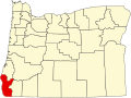 | |
| CDPs | ||
| Other communities | ||
| Ghost town | ||
| Indian reservation | ||
| Footnotes | ‡This populated place also has portions in an adjacent county or counties | |
| International | |
|---|---|
| National | |
This Curry County, Oregon state location article is a stub. You can help Wikipedia by expanding it. |