Osu, Accra
Suburb of Accra
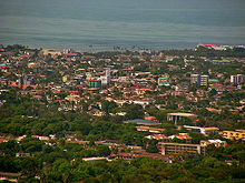
5°33′14″N 0°10′30″W / 5.55389°N 0.17500°W / 5.55389; -0.17500Located about 3 kilometres (1.9 mi) east of the central business district, Osu is a neighborhood in central Accra, Ghana, West Africa . It is locally known as the "West End" of Accra.[1] Bounded to the south by the Gulf of Guinea, Osu's western boundary is the Independence Avenue. Osu is separated from the northern district of Labone by Ring Road. Due to its establishment as a settlement in the 17th century, Osu has a mix of houses dating from the early 20th century and modern office towers.

Economy
The head office of Starbow is in Osu.[2]
Landmarks/places of interest
- Accra International Conference Center
- Accra Ridge Church
- Accra Sports Stadium
- Black Star Square
- Ebenezer Presbyterian Church, Osu
- Independence Arch
- Osu Castle (also known as Fort Christiansborg)
- Parliament House of Ghana
- Ridge Church School
- Greater Accra Regional Hospital
References
External links
 Africa portal

 Media related to Osu (Greater Accra) at Wikimedia Commons


