Overslag, Netherlands
Village in Zeeland, Netherlands

Coat of arms
51°12′3″N 3°53′23″E / 51.20083°N 3.88972°E / 51.20083; 3.88972
(2021)[1]
4575[1]
Overslag is a village in the Dutch province of Zeeland. It is a part of the municipality of Terneuzen, and lies about 36 km southeast of Vlissingen.
The village was first mentioned in 1542 as "ten Overslach", and means place where goods could be transferred. It was located where the canal from Axel and canal from the Belgian Wachtebeke were closed together.[3] It is a border village which is cut in two by the Netherlands-Belgian border. In 1547, the Sassevaart was dug and Overslag become obsolete for the transfer of goods. The parish church is located on the Belgian side. During World War I, it was not possible to completely shut the border and the Wire of Death, a lethal electric fence, ran through the village.[4]
Overslag was a separate municipality until 1970, when it was merged with Axel.[5]
Gallery
-
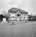 Former town hall
 -
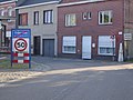 View on Belgian side


References
- ^ a b c "Kerncijfers wijken en buurten 2021". Central Bureau of Statistics. Retrieved 22 April 2022.
two entries
- ^ "Postcodetool for 4575NA". Actueel Hoogtebestand Nederland (in Dutch). Het Waterschapshuis. Retrieved 22 April 2022.
- ^ "Overslag - (geografische naam)". Etymologiebank (in Dutch). Retrieved 22 April 2022.
- ^ "Overslag". Plaatsengids (in Dutch). Retrieved 22 April 2022.
- ^ Ad van der Meer and Onno Boonstra, Repertorium van Nederlandse gemeenten, KNAW, 2011.
Wikimedia Commons has media related to Overslag (Netherlands).
 | This article about a location in Zeeland is a stub. You can help Wikipedia by expanding it. |
- v
- t
- e


