Palmyra Peak
Mountain in the state of Colorado


Palmyra Peak
Location in Colorado
Show map of Colorado
Palmyra Peak
Palmyra Peak (the United States)
Show map of the United StatesColorado, US
San Juan Mountains
Palmyra Peak is a 13,319-foot-elevation (4,060-meter) mountain summit located in San Miguel County of southwest Colorado, United States.[4] It is situated four miles south of the town of Telluride, on land managed by Uncompahgre National Forest. It is part of the San Juan Mountains which are a subset of the Rocky Mountains, and is west of the Continental Divide. It is immediately south of Telluride Ski Resort, from which it is a prominent landmark, and Palmyra has the distinction of having the highest inbounds skiing terrain of any North American ski resort.[5] Topographic relief is significant as the north aspect rises 2,300 feet (700 meters) above Prospect Basin in one mile, and the west aspect rises 2,100 feet above Alta Lakes in one-half mile. The mountain's name has been officially adopted by the United States Board on Geographic Names in association with the Palmyra Mine, a gold and silver mine located at an elevation of 11,650-feet on the peak's western aspect.[6] Other mines on its flanks included Lakeview Mine, Mountain Quail Mine, Roy Johnston mine, and Turkey Creek Mine.
Climate
According to the Köppen climate classification system, Palmyra Peak is located in an alpine subarctic climate zone with cold, snowy winters, and cool to warm summers.[7] Due to its altitude, it receives precipitation all year, as snow in winter, and as thunderstorms in summer, with a dry period in late spring. Precipitation runoff from the mountain drains into Bear Creek and Prospect Creek which are both tributaries of the San Miguel River.
See also
 Mountains portal
 Colorado portal


- Mountains of San Miguel County, Colorado
Gallery
-
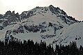
 Palmira Peak seen from the Telluride ski slopes
 -
 Palmyra Peak lined up with parent Silver Mountain behind
 -
 Sunset on Palmyra Peak and Silver Mountain
 -
-
 Palmyra Peak with parent Silver Mountain behind
 -


References
- ^ a b "Palmyra Peak, Colorado". Peakbagger.com.
- ^ Randy Jacobs, Robert M. Ormes, Guide to the Colorado Mountains, 2000, Bower House, ISBN 9780967146607, page 276.
- ^ a b c "Palmyra Peak - 13,319' CO". listsofjohn.com. Retrieved 2021-07-11.
- ^ a b "Palmyra Peak". Geographic Names Information System. United States Geological Survey, United States Department of the Interior. Retrieved 2021-07-11.
- ^ Ski (magazine), December 2008, page 20.
- ^ Palmyra Mine, USGS
- ^ Peel, M. C.; Finlayson, B. L.; McMahon, T. A. (2007). "Updated world map of the Köppen−Geiger climate classification". Hydrol. Earth Syst. Sci. 11. ISSN 1027-5606.
External links
- Weather forecast: Palmyra Peak
- Palmyra Peak (left) and Silver Mountain (right) photo: Flickr


