Puerto Leguízamo
Municipality and town in Putumayo Department, Colombia

Flag

Seal
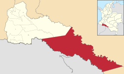
Location of the municipality and town of Puerto Leguízamo in the Putumayo Department of Colombia.
 Colombia
 Putumayo Department
 (2018 census)[1]
Puerto Leguízamo[2] (Spanish pronunciation: [ˈpweɾto leɣiˈsamo]) is a town and municipality located in the Putumayo Department, a southern border region of the Republic of Colombia. It is on the north bank of the Putumayo River.
Its Catedral Nuestra Señora del Carmen, dedicated to Our Lady of Mount Carmel, is the cathedral episcopal see of the Latin Catholic missionary pre-diocesan Apostolic Vicariate of Puerto Leguízamo-Solano.
Puerto Leguízamo is served by Caucayá Airport.
Climate
Located just a few kilometres south of the equator, Puerto Leguízamo has a tropical rainforest climate (Af) with heavy to very heavy rainfall year-round.
| Climate data for Puerto Leguízamo | |||||||||||||
|---|---|---|---|---|---|---|---|---|---|---|---|---|---|
| Month | Jan | Feb | Mar | Apr | May | Jun | Jul | Aug | Sep | Oct | Nov | Dec | Year |
| Mean daily maximum °C (°F) | 32.1 (89.8) | 31.8 (89.2) | 31.5 (88.7) | 30.6 (87.1) | 30.7 (87.3) | 29.5 (85.1) | 28.5 (83.3) | 30.5 (86.9) | 31.9 (89.4) | 30.3 (86.5) | 31.9 (89.4) | 30.7 (87.3) | 30.8 (87.5) |
| Daily mean °C (°F) | 27.4 (81.3) | 27.2 (81.0) | 26.6 (79.9) | 26.2 (79.2) | 26.3 (79.3) | 25.3 (77.5) | 24.7 (76.5) | 25.5 (77.9) | 26.4 (79.5) | 26.3 (79.3) | 27.2 (81.0) | 26.5 (79.7) | 26.3 (79.3) |
| Mean daily minimum °C (°F) | 22.8 (73.0) | 22.7 (72.9) | 21.8 (71.2) | 21.9 (71.4) | 22.0 (71.6) | 21.2 (70.2) | 20.9 (69.6) | 20.6 (69.1) | 20.9 (69.6) | 22.4 (72.3) | 22.6 (72.7) | 22.3 (72.1) | 21.8 (71.3) |
| Average rainfall mm (inches) | 108 (4.3) | 175 (6.9) | 218 (8.6) | 307 (12.1) | 360 (14.2) | 377 (14.8) | 335 (13.2) | 276 (10.9) | 263 (10.4) | 250 (9.8) | 192 (7.6) | 131 (5.2) | 2,992 (118) |
| Source: Climate-Data.org[3] | |||||||||||||
References
External links
- (in Spanish) Informacion Ambiental de la Amazonia colombiana
- v
- t
- e
Municipalities in the Putumayo Department

0°11′38″S 74°46′50″W / 0.19389°S 74.78056°W / -0.19389; -74.78056
 | This Department of Putumayo location article is a stub. You can help Wikipedia by expanding it. |
- v
- t
- e


