Punchbowl, New South Wales
Suburb of City of Canterbury-Bankstown, New South Wales, Australia
| Punchbowl New South Wales | |||||||||||||||
|---|---|---|---|---|---|---|---|---|---|---|---|---|---|---|---|
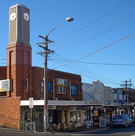 The Boulevarde, Punchbowl c. 2007 | |||||||||||||||
 | |||||||||||||||
| Population | 20,236 (2016 census)[1] | ||||||||||||||
| Established | 1869 | ||||||||||||||
| Postcode(s) | 2196 | ||||||||||||||
| Elevation | 40 m (131 ft) | ||||||||||||||
| Location | 17 km (11 mi) south-west of Sydney CBD | ||||||||||||||
| LGA(s) | City of Canterbury-Bankstown | ||||||||||||||
| State electorate(s) | Lakemba | ||||||||||||||
| Federal division(s) |
| ||||||||||||||
| |||||||||||||||
Punchbowl is a suburb in the south west of Sydney, 17 kilometres (11 mi) west of the Sydney central business district, in the local government area of the City of Canterbury-Bankstown, in the state of New South Wales, Australia. At the 2016 census, Punchbowl had a population of 20,236.[1]
History

Punchbowl is named for a circular valley, called "the punchbowl", which is actually located in the nearby suburb of Belfield at the intersection of Coronation Parade, Georges River and Punchbowl Roads. This feature gave its name to "Punch Bowl Road" (now Punchbowl Road). In the 1830s, an inn built by George Faulkener, close to the corner of Liverpool Road, was called the Punch and Bowl. John Stephens had a property there in the 1830s and his son is mentioned in the Wells Gazetteer in 1848, "Clairville or Punchbowl, in the Parishes of St George and Bankstown, is the property of Sir Alfred Stephens". When a railway station opened on this road in 1909, three kilometres (1.9 mi) away from the 'punch bowl' itself, the surrounding suburb came to be known as Punchbowl.[2]
In the 1920s and 1930s, Punchbowl was a higher-class suburb, with a number of popular theatres that were closed down or demolished thirty years later. The Punchbowl Astoria opened on 17 July 1935 with seating for 915 persons. The final programme was shown on Wednesday 4 February 1959. The Astoria was eventually gutted and refitted as a three-storey office building. The Punchbowl Regent was situated on the corner of The Boulevarde and Matthews Street. Operated by Enterprise Theatres Ltd, the Regent opened on Saturday 24 May 1923, showing The White Rose. It was a large cinema with seating for 1,287 patrons. The last programme was shown on Wednesday 4 February 1959. The Regent was demolished in August 1964 and replaced by a block of shops.
Until 1987, Roselands was a neighbourhood within Punchbowl, though they still share the same postcode today (2196).
Commercial area
Punchbowl has a relatively small shopping centre, although the selection is diverse. It thrived until the advent of Roselands and Bankstown Square in the late 1960s and its bisection by the upgrading of Punchbowl Road in the 1970s. It is centred on Punchbowl railway station, along The Boulevarde and Punchbowl Road. Local businesses and clubs reflect the diversity of the population. Punchbowl RSL was located on The Boulevarde until it closed in 2010 and The Mirage Hotel is on Punchbowl Road. Lebanese cuisine is well regarded in the suburb, to the extent that culinary walking tours of Punchbowl sell out months ahead.[3] There are a number of Lebanese sweet shops in the suburb. In 2009, a gym opened at the Astoria theatre site.
For many years, Jack Walsh International Cycles, on Punchbowl Road, was one of the longest-serving shops in Punchbowl. It had been selling and repairing bicycles for over 60 years,[4] until December 2007 when Walsh was unable to continue the business.
In December 2013 a new shopping centre, "The Broadway Plaza", was opened in Punchbowl "Broadway" near its train station.[5] It comprises two levels of retail stores including Woolworths and Chemist Warehouse. The Plaza is surrounded by a complex of seven blocks of new apartments.
Transport
Canterbury Road and Punchbowl Road provide the major road links into the suburb. The Boulevarde and South Terrace are also main roads. Punchbowl railway station is located on the Bankstown line of the Sydney Trains network. The line was opened in 1895 and electrified in 1926. Trains take around 25 minutes to Sydenham and 40 minutes to Central station.
The Punchbowl Road railway bridge replaced an old two-lane bridge in 1981.[citation needed] The foundations of the old bridge can still be seen west of the current one. The new bridge greatly aided traffic flow through the area but at the cost of effectively cutting the shopping centre in half.
Punchbowl within the City of Canterbury-Bankstown
Housing

Punchbowl is a mainly residential suburb. Much of the suburb was developed in the late 19th century and early 20th century, especially after the railway line to Bankstown was built. The suburb features a mixture of Federation, Art Deco and contemporary homes. Parts of Punchbowl have been redeveloped since the turn of the 21st century, with flats, townhouses and modern detached houses built.
Schools

- Punchbowl Boys High School in Kelly Street,[6] was established in 1955.
- The school produced two Australian cricket fast bowlers, Len Pascoe and Jeff Thomson.
- Punchbowl Public School is located on Canterbury Road.[7]
- Saint Charbel's College is located on Highclere Avenue.[8]
- Saint Jeromes Catholic Primary School is located on Rossmore Avenue,[9]
Demographics
The first Europeans in the area were British and Irish settlers in the 19th century. By the mid-20th century, the suburb had absorbed many migrants of Italian and Greek origin.[citation needed] From the mid-1970s, Punchbowl became a very popular location with migrants from Lebanon.[citation needed]
At the 2021 census, there were 21,384 people in Punchbowl. 45.0% of people were born in Australia. The most common other countries of birth were Lebanon 12.3%, Vietnam 5.4%, Bangladesh 3.0%, China 2.8% and Pakistan 2.7%. The most common reported ancestries were Lebanese 26.9%, Australian 12.0%, Chinese 6.8%, Vietnamese 6.8% and English 6.7%. 22.3% of people only spoke English at home. Other languages spoken at home included Arabic 33.7%, Vietnamese 6.9, Urdu 4.0%, Bengali 3.9% and Greek 3.4%. The most common responses for religion were Islam 38.4% and Catholic 22.6%.[1]
Notable residents
- Danny Adcock, actor
- Lex Banning (1921–1965), poet
- Mark Bouris, businessman
- John Burgess, television host
- Wes Davoren (1928–2010), politician
- Yahya El Hindi, association football player
- Akmal Saleh, comedian
- Mark Saliba, comedian and amateur prizefighter
- Vince Sorrenti, comedian
- The Hard-Ons, a punk rock band
Fictional characters
In popular culture
- Punchbowl has featured in several Australian books including the satirical They're a Weird Mob by "Nino Culotta" (a nom de plume of John O'Grady), which was made into a feature film of the same name. The Mirage Hotel was referred to in the film as "the bloodhouse".
- The film The FJ Holden (1977) featured several locations in Punchbowl including the Sundowner Hotel on the corner of Punchbowl and Canterbury Roads, a popular pub and band venue until the licence was sold. The buildings served as a Croatian Club until a new club was built.
- The television drama series Dangerous was set in and around Punchbowl.
- YouTube celebrity Trent from Punchy is a fictional character portrayed by Nicholas Boshier.[10] The character's name is derived from his claim to be from Punchbowl.[11][12]
See also
References
- ^ a b c Australian Bureau of Statistics (27 June 2017). "Punchbowl (Canterbury - NSW State Suburb)". 2016 Census QuickStats. Retrieved 1 August 2017.

- ^ The Book of Sydney Suburbs, Compiled by Frances Pollon, Angus & Robertson Publishers, 1990, Published in Australia ISBN 0-207-14495-8, page 210
- ^ Gourmet Safaris Archived 2 October 2007 at the Wayback Machine
- ^ Tribute to Mr Jack Walsh NSW Parliament
- ^ "The Broadway- Punchbowl". Archived from the original on 14 January 2014. Retrieved 11 December 2016.
- ^ "Punchbowl Boys High School - Home". Retrieved 11 December 2016.
- ^ "Punchbowl Public School - Home". Retrieved 11 December 2016.
- ^ St Charbel's College.
- ^ "St Jerome's Catholic Primary School". Retrieved 11 December 2016.
- ^ Evans, Mel (2 November 2014). "The Hip List: Bondi Hipsters Christiaan Van Vuuren and Nick Boshier, aka Dom and Adrian, are Soul Mates". The Daily Telegraph. Sydney. Retrieved 7 November 2014.
- ^ Barrett, David (2 September 2008). "'Trent from Punchy' divides online bloggers". The Australian. Retrieved 7 November 2014.
- ^ Watson, Callie; Zwaans, Lauren (26 May 2009). "Enjoying 15 minutes of fame". The Advertiser. Retrieved 9 November 2014.
33°56′S 151°03′E / 33.933°S 151.050°E / -33.933; 151.050
External links
Wikimedia Commons has media related to Punchbowl, New South Wales.
- Canterbury City Council - History of Punchbowl at the Library of Congress Web Archives (archived 2009-05-31)
- v
- t
- e
City of Canterbury-Bankstown suburbs, localities, and other topics
within City of Canterbury-Bankstown
- Ashbury
- Bankstown
- Bankstown Aerodrome
- Bass Hill
- Belfield
- Belmore
- Beverly Hills
- Birrong
- Campsie
- Canterbury
- Chester Hill
- Chullora
- Clemton Park
- Condell Park
- Croydon Park
- Earlwood
- East Hills
- Georges Hall
- Greenacre
- Hurlstone Park
- Kingsgrove
- Lakemba
- Lansdowne
- Leightonfield
- Milperra
- Mount Lewis
- Narwee
- Padstow
- Padstow Heights
- Panania
- Picnic Point
- Potts Hill
- Punchbowl
- Regents Park
- Revesby
- Revesby Heights
- Riverwood
- Roselands
- Sefton
- Undercliffe
- Villawood
- Wiley Park
- Yagoona
- 118th General Hospital (United States Army)
- Bankstown Bunker
- HMS Nabberley
- Milperra massacre
- No. 1 Fighter Sector RAAF
- Sydney gang rapes
- Airport line
- Bankstown Line
- Bankstown station
- Belmore station
- Birrong station
- Campsie station
- Canterbury station
- Chester Hill station
- East Hills station
- Hurlstone Park station
- Lakemba station
- Leightonfield station
- Padstow station
- Panania station
- Punchbowl station
- Revesby station
- Sefton station
- Villawood station
- Wiley Park station
- Yagoona station
public parks
past and present
- Josh Addo-Carr
- Bryan Brown
- John Burgess
- Paulini Curuenavuli
- Tyler De Nawi
- Alex Dimitriades
- Anh Do
- Casey Donovan
- Taj El-Din Hilaly
- Brett Emerton
- Blake Ferguson
- Mamdouh Habib
- John Howard
- Hard-Ons
- Brett Holman
- Paul Keating
- Terry Lamb
- Ken Moroney
- Kevin Moss
- Anthony Mundine
- Rebecca Rippon
- Geoff Robinson
- Akmal Saleh
- Bilal Skaf
- Vince Sorrenti
- Ian Thorpe
- Mark Waugh
- Steve Waugh
- Federal divisions
- State districts
- Ashfield Reservoir
- Bankstown Bites Food Festival
- Bankstown Central
- Bethungra, Canterbury
- Canterbury Bankstown region
- Chipping Norton Lake
- Cooks River Sewage Aqueduct
- Duck River (New South Wales)
- Earlwood Aboriginal Art Site
- Henry Lawson Drive
- King Georges Road
- Lakemba Mosque
- Meccano Set
- Old Sugarmill
- Pressure Tunnel and Shafts
- Roselands Shopping Centre
- The Homestead
- Wolli Creek Aqueduct


