Puracé, Cauca
You can help expand this article with text translated from the corresponding article in Spanish. (June 2020) Click [show] for important translation instructions.
- View a machine-translated version of the Spanish article.
- Machine translation, like DeepL or Google Translate, is a useful starting point for translations, but translators must revise errors as necessary and confirm that the translation is accurate, rather than simply copy-pasting machine-translated text into the English Wikipedia.
- Consider adding a topic to this template: there are already 5,023 articles in the main category, and specifying
|topic=will aid in categorization. - Do not translate text that appears unreliable or low-quality. If possible, verify the text with references provided in the foreign-language article.
- You must provide copyright attribution in the edit summary accompanying your translation by providing an interlanguage link to the source of your translation. A model attribution edit summary is
Content in this edit is translated from the existing Spanish Wikipedia article at [[:es:Puracé - Coconuco]]; see its history for attribution. - You may also add the template
{{Translated|es|Puracé - Coconuco}}to the talk page. - For more guidance, see Wikipedia:Translation.
Municipality and town in Cauca Department, Colombia
Flag
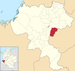
Location of the municipality and town of Puracé in the Cauca Department of Colombia.
 Colombia
 (Census 2018[2])

Puracé (Spanish pronunciation: [puɾaˈse]) is a town and municipality in the Cauca Department, Colombia.
An 1853 watercolor by Manuel María Paz is an early depiction of four indigenous people in Puracé wearing straw hats and ruanas.[3]
References
- ^ "Municipalities of Colombia". statoids. Retrieved 28 April 2020.
- ^ "Censo Nacional de Población y Vivienda 2018" (in Spanish). DANE. Retrieved 28 April 2020.
- ^ Paz, Manuel María. "Indians of Puracé, Popayán Province". World Digital Library. Retrieved 2014-05-21.
- v
- t
- e
Municipalities in the Cauca Department
- Almaguer
- Argelia
- Balboa
- Bolívar
- Buenos Aires
- Cajibio
- Caldono
- Caloto
- Corinto
- El Tambo
- Florencia
- Guachené
- Guapi
- Inzá
- Jambaló
- La Sierra
- La Vega
- López de Micay
- Mercaderes
- Miranda
- Morales
- Padilla
- Páez
- Patía
- Piamonte
- Piendamó
- Popayán
- Puerto Tejada
- Puracé
- Rosas
- San Sebastián
- Santander de Quilichao
- Santa Rosa
- Silvia
- Sotara
- Suárez
- Sucre
- Timbío
- Timbiquí
- Toribío
- Totoró
- Villa Rica

2°15′N 76°25′W / 2.250°N 76.417°W / 2.250; -76.417
 | This Department of Cauca location article is a stub. You can help Wikipedia by expanding it. |
- v
- t
- e


