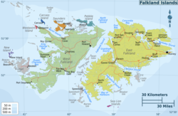

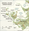
Quaker Harbour is the irregularly shaped bay indenting for 3.7 km the north coast of Weddell Island in the Falkland Islands.[1] It is centred at 51°49′00″S 61°04′35″W / 51.81667°S 61.07639°W, and has its head fed by Pitt Creek. The bay takes its name from nearby Quaker Island.
The British navigator and Antarctic explorer James Weddell, who visited the Falklands in 1819–1824, overwintered ashore on Weddell Island (known at that time as Swan Island) at Quaker Harbour in May–September 1823.[2]
Maps
[edit]- The Falkland Islands. Scale 1:401280 map. London: Edward Stanford, 1901
- Falkland Islands Explorer Map. Scale 1:365000. Ocean Explorer Maps, 2007
- Falklands Topographic Map Series. Scale 1:50000, 29 sheets. DOS 453, 1961-1979
- Falkland Islands. Scale 1:643000 Map. DOS 906. Edition 3-OS, 1998
- Map 500k--xm20-4. 1:500000 map of Weddell Island and part of West Falkland. Russian Army Maps (for the world)
- Approaches to the Falkland Islands. Scale 1:1500000 chart. Gps Nautical Charts, 2010
- Illustrated Map of Weddell Island
Gallery
[edit]-
 Swan Island (present Weddell Island) and Quaker Harbour on a pre 1829 Falklands map by Charles Barnard
 -
 Old map of Weddell Island featuring Quaker Harbour
 -
 Map of Weddell Island


Notes
[edit]- ^ Quaker Harbour. Falkland Islands. GeoNames Geographical Database
- ^ J. Weddell. A Voyage Towards the South Pole, Performed in the Years 1822–24. London: Longman, Hurst, Rees, Orne, Brown and Green, 1825. p. 77
References
[edit]- B. Stonehouse (ed.). Encyclopedia of Antarctica and the Southern Oceans. Chichester, West Sussex: John Wiley & Sons, 2002. 404 pp. ISBN 978-0-471-98665-2
- C.H. Barnard. A Narrative of the Sufferings and Adventures of Capt. Charles H. Barnard, in a Recent Voyage Round the World, Including an Account of His Residence for Two Years on An Uninhabited Island. New York: J.P. Callender, 1836
- P.P. King and R. Fitzroy. The South America Pilot. Part II. From the Rio de la Plata to the Bay of Panama, including Magellan Strait, the Falkland, and Galapagos Islands. Fifth Edition. London: Printed for the Hydrographic Office, Admiralty, 1860. pp. 116–118
External links
[edit]- Weddell Island Official Website Archived 22 March 2018 at the Wayback Machine
- Weddell Island from space.[usurped] NASA Johnson Space Center, 30 April 2005
This Weddell Island-related article is a stub. You can help Wikipedia by expanding it. |