Queen's Gardens, Croydon

The Queen's Gardens is a public garden in the centre of Croydon, South London. The gardens are bordered by Croydon Town Hall, Bernard Weatherill House, the site of the former Taberner House, Park Lane and Katharine Street.
In their present form, and under their present name, the gardens and their central fountain were opened by Queen Elizabeth II in 1983. The area had previously consisted of the smaller Town Hall Gardens, and the site of Croydon's police station. The Town Hall Gardens had originally been laid out in the 1890s on the site of the disused spur railway line leading to Croydon Central station.
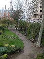
The gardens now comprise areas of lawn with standard trees, a central fountain with benches, and a sunken garden area with formal flower beds and trees exploiting the former track bed and station wall complete with original railings on top. Situated just across from Croydon's register office, the gardens are popular for wedding photographs. A subway exits the park under Park Lane into an underground car park and across to the Fairfield Halls: the gardens are regularly used as a route between the Council offices and the underpass.
The cancelled Park Place development featured proposals to radically alter the Queen's Gardens, with a more formal and modern planting style, an ice rink, space for performances and entrance into the Park Place shopping centre. The gardens remain part of the Croydon Vision 2020 regeneration plan.
After Taberner House was demolished in 2014–2015, the former site was redeveloped with completion expected in late 2021. The new housing created extended into the Queen's Gardens itself and there was some concern that the former urban ornamental park had effectively been absorbed into the new project for the use of the residents.[1]
Gallery
-
 The retaining wall in the cutting east of Central Croydon Station, now part of Queen's Gardens
 -
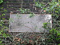 Plaque on retaining wall commemorating the Station's history
 -
 The retaining wall viewed eastwards towards Fairfield Halls
 -
 Close-up of the retaining wall
 -
 The retaining wall viewed westwards towards the Town Hall


See also
References
- ^ insidecroydon (23 June 2021). "After eight-year wait, Taberner House flats near completion". Inside Croydon. Retrieved 29 September 2021.
- (1997) Hidden History in Croydon's Parks, Croydon Council
- v
- t
- e
- Addington
- Addiscombe
- Beddington
- Broad Green
- Coombe
- Coulsdon
- Croydon
- Crystal Palace
- Forestdale
- Hamsey Green
- Kenley
- Monks Orchard
- New Addington
- Norbury
- Norwood New Town
- Old Coulsdon
- Old Town
- Pollards Hill
- Purley
- Russell Hill
- Sanderstead
- Selhurst
- Selsdon
- Shirley (Including Shirley Oaks and Upper Shirley)
- South Croydon
- South Norwood
- Spring Park
- Thornton Heath
- Upper Norwood
- Waddon
- Woodcote
- Woodside
- Whyteleafe


open spaces
- Addington Hills
- Addington Park
- Addington Vale
- Addiscombe Railway Park
- Addiscombe Recreation Ground
- Apsley Road Playground
- Ashburton Park
- Ashburton Playing Fields
- Beaulieu Heights
- Bramley Bank
- Brickfields Meadow
- Coombe Wood
- Cotelands
- Croham Hurst
- Duppas Hill
- Farthing Downs
- Foxley Wood
- Grangewood Park
- Great North Wood
- Happy Valley Park
- Heathfield House
- Heavers Meadow
- Hutchinson's Bank
- Kenley Common
- Littleheath Woods
- Lloyd Park
- Mitcham Common
- Norwood Grove
- Park Hill
- Pollards Hill
- Queen's Gardens
- Riddlesdown Common
- Roundshaw
- Selsdon Wood
- South Norwood Country Park
- South Norwood Lake and Grounds
- South Norwood Recreation Ground
- Spa Wood
- Wandle Park
- Woodside Green
- Croydon South
- Croydon Central
- Croydon North
- Addiscombe East
- Addiscombe West
- Bensham Manor
- Broad Green
- Coulsdon Town
- Crystal Palace & Upper Norwood
- Fairfield
- Kenley
- New Addington North
- New Addington South
- Norbury & Pollards Hill
- Norbury Park
- Old Coulsdon
- Park Hill & Whitgift
- Purley & Woodcote
- Purley Oaks & Riddlesdown
- Sanderstead
- Selhurst
- Selsdon & Addington Village
- Selsdon Vale & Forestdale
- Shirley North
- Shirley South
- South Croydon
- South Norwood
- Thornton Heath
- Waddon
- West Thornton
- Woodside
and tram stops
- Addington Village
- Addiscombe
- Ampere Way
- Arena
- Blackhorse Lane
- Centrale
- Church Street
- Coombe Lane
- Coulsdon South
- Coulsdon Town
- East Croydon
- Fieldway
- George Street
- Gravel Hill
- Harrington Road
- Kenley
- King Henry's Drive
- Lebanon Road
- Lloyd Park
- New Addington
- Norbury
- Norwood Junction
- Purley Oaks
- Purley
- Reedham
- Reeves Corner
- Riddlesdown
- Sanderstead
- Sandilands
- Selhurst
- South Croydon
- Thornton Heath
- Waddon
- Waddon Marsh
- Wandle Park
- Wellesley Road
- West Croydon
- Woodmansterne
- Woodside
 Category
 Commons

51°22′18″N 0°05′52″W / 51.3718°N 0.0978°W / 51.3718; -0.0978


