Reichenau Island
Island in Germany
Germany
UNESCO World Heritage Site
Reichenau Island[a] (German: [ˈʁaɪçənaʊ]) is an island in Lake Constance in Southern Germany. It lies almost due west of the city of Konstanz, between the Gnadensee and the Untersee, two parts of Lake Constance. With a total land surface of 4.3 km2 (1.7 sq mi) and a circumference of 11 km (6.8 mi), the island is 4.5 km (2.8 mi) long and 1.5 km (0.93 mi) wide at its greatest extent. The highest point, the Hochwart, stands some 43 m (141 ft) above the lake surface and 438.7 m (1,439 ft) above mean sea level.
Reichenau is connected to the mainland by a causeway, completed in 1838, which is intersected between the ruins of Schopflen Castle and the eastern end of Reichenau Island by a 10-metre-wide (33 ft) and 95-metre-long (312 ft) waterway, the Bruckgraben. A low road bridge allows the passage of ordinary boats but not of sailing-boats.
In 724, the first monastery was built on the island by bishop Pirmin, and Reichenau quickly developed into an influential religious, cultural, and intellectual center.[1] During the Early and High Middle Ages, the Reichenau Abbey was one of the significant monasteries across the Frankish Empire. Because of its historical importance and the exceptional quality of the architecture and artwork found in the island's three churches and abbey, Reichenau was declared a World Heritage Site in 2000.[2]
History
Although people occupied Reichenau in the Bronze Age and Iron Age, archeological evidence suggests that Reichenau was abandoned during the Roman era.[3] Uninhabited until 724, when Saint Pirmin received support from the Carolingian ruler Charles Martel to build a monastery on the island.[1] The first abbey, at Mittelzel, was wooden, although it was replaced by a stone building by 746.[4] In the early 9th century, under the patronage of the Carolingian dynasty and Ottonian dynasty, the monastery flourished. In 816 the abbey was rebuilt in a cruciform basilica style, churches dedicated to the Virgin and Saint Mark were consecrated.[1] Relics of St. Mark arrived at the abbey in the mid-9th century. Two further churches were built on the island consecrated to Saints Peter and Paul (in 799) and to Saint George (in 896).[4]
The abbey's bailiff was housed in a two-storey stone building to which two more storeys of timber framing were added in the 14th century, one of the oldest timber-frame buildings in south Germany. It is today used as a museum of local history.[1]
In addition to being a religious center, Reichenau attracted influential poets and authors such as Walafrid Strabo (who served as abbot) and scientists and scholars such as Hermann of Reichenau and artists.[1] The famous artworks of Reichenau include (in the church of St George) the Ottonian murals of miracles of Christ, unique survivals from the 10th century.[4][1] The Plan of St. Gall, the only surviving architectural drawing from the Middle Ages, may also have been created on the island.[1] Among the Abbey's far-flung landholdings was Reichenau, a village on the upper Rhine in the municipality of Tamins in the canton of Graubünden, Switzerland, named for the Abbey.
In the 16th century, the Prince-Bishopric of Constance was extended to include Reichenau, and as a result the influence of the monastery waned. During the secularization of the Prince-Bishopric of Constance in 1803, many of the smaller chapels on the island were demolished.[4] In addition, the manuscripts and archives held in the abbey were given to Karlsruhe and the University of Heidelberg library and the surrounding farms were parceled and sold.
Today the island is also famous for its vegetable farms. The Wollmatinger Ried next to the island is a large nature reserve, a wetland area of reeds which is used by many birds as a stopover during their annual migration.
Gallery
-
 15th-century towers on the Romanesque church of Sts Peter and Paul in Reichenau-Niederzell
 -
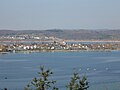
 South West Reichenau Island
 -
 South East Reichenau Island
 -
 St. Georg, Reichenau-Oberzell
 -
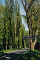 Aspen-lined Avenue to Reichenau Island
 -
 One of the island's many vegetable fields with Sankt Georg Kirche in the background


Notes
References
- ^ a b c d e f g A. Zettler (5 September 1999). Report on the Nomination of the Monastic Island of Reichenau for Inscription on the World Heritage List of UNESCO (PDF) (Report). Historisches Institut, Universitat Dortmund. Retrieved 20 August 2022.
- ^ "Monastic Island of Reichenau". UNESCO World Heritage Centre. United Nations Educational, Scientific, and Cultural Organization.
- ^ Helmut Schlichtherle (1999). Settlement and History of the Island of Reichenau From the Beginning Until Pre-Monastery Times (PDF) (Report). Retrieved 20 Aug 2022.
- ^ a b c d Reichenau (Germany) - No. 974 (Report). ICOMOS. 28 June 1999. Retrieved 20 Aug 2022.
External links
Wikivoyage has a travel guide for Reichenau.
Wikimedia Commons has media related to Reichenau Island.
- Monastic Island of Reichenau UNESCO Official Website
- Reichenau: monastic island
- (in German) History and images
- Reichenau Abbey Church
 Herbermann, Charles, ed. (1913). "Reichenau". Catholic Encyclopedia. New York: Robert Appleton Company.
- 3 spherical panoramas of St. Georg Church
- Saint George in Overzell in Circulo Romanico page
- Abacial de Santa Maria y San Marcos in Circulo Romanico page
- Iglesia de San Pedro y san Pablo in Circulo Romanico
- v
- t
- e
For official site names, see each article or the List of World Heritage Sites in Germany.
- ADGB Trade Union School
- Berlin Modernism Housing Estates
- Bremen Town Hall and Roland on the Marketplace
- Fagus Factory in Alfeld
- Hedeby and the Danevirke Archaeological Border Complex
- St. Mary's Cathedral and St. Michael's Church at Hildesheim
- Museumsinsel (Museum Island), Berlin
- Hanseatic City of Lübeck
- Palaces and Parks of Potsdam and Berlin
- Mines of Rammelsberg, Historic Town of Goslar and Upper Harz Water Management System
- Speicherstadt and Kontorhaus District with Chilehaus in Hamburg
- Historic Centres of Stralsund and Wismar
- Bauhaus and its Sites in Weimar, Dessau and Bernau
- Dessau-Wörlitz Garden Realm
Dresden Elbe Valley(delisted in 2009)- Erzgebirge/Krušnohoří Mining Region1
- Luther Memorials in Eisleben and Wittenberg
- Muskauer Park / Park Mużakowski2
- Naumburg Cathedral
- Collegiate Church, Castle, and Old Town of Quedlinburg
- Wartburg Castle
- Classical Weimar
- Aachen Cathedral
- Castles of Augustusburg and Falkenlust at Brühl
- Bergpark Wilhelmshöhe
- Cologne Cathedral
- Carolingian Westwork and Civitas Corvey
- Upper Middle Rhine Valley
- Roman Monuments, Cathedral of St. Peter and Church of Our Lady in Trier
- Speyer Cathedral
- ShUM cities of Speyer, Worms and Mainz
- Great Spa Towns of Europe8
- Völklingen Ironworks
- Zollverein Coal Mine Industrial Complex in Essen
- Abbey and Altenmünster of Lorsch
- The Architectural Work of Le Corbusier
- Augsburg Water Management System
- Town of Bamberg
- Caves and Ice Age Art in the Swabian Jura
- Mathildenhöhe Darmstadt
- Frontiers of the Roman Empire in Bavaria7
- Frontiers of the Roman Empire:3 Upper Germanic & Rhaetian Limes
- Maulbronn Monastery Complex
- Margravial Opera House
- Monastic Island of Reichenau
- Old Town of Regensburg with Stadtamhof
- Pilgrimage Church of Wies
- Prehistoric pile dwellings around the Alps4
- Würzburg Residence with the Court Gardens and Residence Square
- 1 Shared with the Czech Republic
- 2 Shared with Poland
- 3 Shared with the United Kingdom
- 4 Shared with Austria, France, Italy, Slovenia and Switzerland
- 5 Shared with Albania, Austria, Belgium, Bosnia and Herzegovina, Bulgaria, Croatia, Czech Republic, France, Italy, North Macedonia, Poland, Romania, Slovakia, Slovenia, Spain, Switzerland and Ukraine
- 6 Shared with the Netherlands and Denmark
- 7 Shared with Austria and Slovakia
- 8 Shared with France, Austria, Belgium, Czechia, Italy, UK
| ||
|---|---|---|
| Inhabited |
|  |
| Uninhabited |
| |
| Former |
| |
Authority control databases | |
|---|---|
| International |
|
| National |
|
| Other |
|


