Rev, Nagorno-Karabakh
Place in Khojaly, Azerbaijan
Rev / Shalva Ռև / Şəlvə | |
|---|---|
 | |
39°59′09″N 46°42′50″E / 39.98583°N 46.71389°E / 39.98583; 46.71389 | |
| Country |  Azerbaijan Azerbaijan |
| • District | Khojaly |
| Elevation | 984 m (3,228 ft) |
| Population (2015)[1] | |
| • Total | 110 |
| Time zone | UTC+4 (AZT) |
Rev (Armenian: Ռև, also Rrev) or Shalva (Azerbaijani: Şəlvə) is a village in the Khojaly District of Azerbaijan. It was under the de facto control of breakaway Republic of Artsakh until the Azerbaijani takeover of the region in 2023.[2]
History
During the Soviet period, the village was a part of the Askeran District of the Nagorno-Karabakh Autonomous Oblast.
Historical heritage sites
Historical heritage sites in and around the village include an 18th/19th-century cemetery, St. Stephen's Church (Armenian: Սուրբ Ստեփանոս եկեղեցի, romanized: Surb Stepanos Yekeghetsi) built in 1894, and a 19th-century spring monument.[1]
Economy and culture
The population is mainly engaged in agriculture and animal husbandry. As of 2015, the village has a municipal building, a house of culture, and a medical centre. Students study in the secondary school of the neighboring village of Tsaghkashat.[1]
Demographics
The village has an ethnic Armenian-majority population. It had 113 inhabitants in 2005,[3] and 110 inhabitants in 2015.[1]
Gallery
-
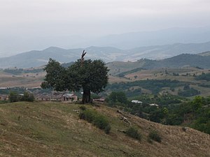
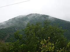 Scenery
 -
 St. Stephen's Church
 -
 Municipal building
 -
 First aid station
 -
 Buildings in the village
 -
 WWII memorial


References
- ^ a b c d Hakob Ghahramanyan. "Directory of socio-economic characteristics of NKR administrative-territorial units (2015)".
- ^ Nagorno-Karabakh’s breakaway government says it will dissolve itself, The Guardian, 28 Sep 2023, archieved on 15 Nov 2023
- ^ "The Results of the 2005 Census of the Nagorno-Karabakh Republic" (PDF). National Statistic Service of the Republic of Artsakh.
External links
Wikimedia Commons has media related to Şəlvə (Xocalı).
- Rev, Nagorno-Karabakh at GEOnet Names Server
- v
- t
- e
Capital: Askeran

- Astghashen
- Aygestan
- Berkadzor
- Dahrav
- Dahraz
- Dashushen
- Harav
- Hilis
- Hovsepavan
- Ivanyan
- Jamilli
- Karmirgyugh
- Khachen
- Khachmach
- Khandzk
- Khnapat
- Khnatsakh
- Khndzristan
- Khramort
- Krasni
- Kyatuk
- Lusadzor
- Mkhitarashen
- Nakhijevanik
- Nerkin Sznek
- Noragyugh
- Patara
- Parukh
- Rev
- Sardarashen
- Sarnaghbyur
- Sarushen
- Shosh
- Tsaghkashat
- Urakhach
- Varazabun
- Vardadzor
- Verin Sznek

Portal:
 Geography

 | This Khojaly District location article is a stub. You can help Wikipedia by expanding it. |
- v
- t
- e
 | This Artsakh location article is a stub. You can help Wikipedia by expanding it. |
- v
- t
- e


