Rottnan
River in Norway, Sweden
60°33′01″N 12°25′21″E / 60.550197476°N 12.42260019°E / 60.550197476; 12.42260019 • location
• coordinates
• elevation
Rottnan (Swedish) or Rotna (Norwegian) is a 110-kilometre (68 mi) long river in Norway and Sweden. The river starts south of Hof Finnskog in Solør, Norway and discharges into lake Fryken at Rottneros in Värmland, Sweden. The river passes through the municipalities of Åsnes and Grue in Innlandet county, Norway and through the municipalities of Torsby and Sunne in Värmland County in Sweden.[3]
Rottnan used to have three waterfalls close to the mouth in Fryken. Rottnafallet was the last and tallest at 26 metres (85 ft) height. The waterfalls were built in 1927 for hydroelectric power. The name Rottnan comes from the old Swedish word Rotn which means "the roaring".
-
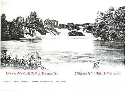 The waterfall Skarpedsfallet in Rottneros, Sweden
 -
 The waterfall Rottnafallet and the pulp mill Rottneros bruk in Rottneros, Sweden


See also
References
- ^ a b "Rottnan". Nationalencyklopedin (in Swedish). Retrieved 14 July 2010. (subscription required)
- ^ a b "SMHI".
- ^ Thorsnæs, Geir, ed. (6 January 2020). "Rotna". Store norske leksikon (in Norwegian). Kunnskapsforlaget. Retrieved 13 March 2022.
External links
- More pictures of the waterfalls.
- Pictures of the river from source to mouth.
- v
- t
- e
This article related to a river in Sweden is a stub. You can help Wikipedia by expanding it. |
- v
- t
- e


