São Pedro do Sul, Portugal
You can help expand this article with text translated from the corresponding article in German. (October 2015) Click [show] for important translation instructions.
- View a machine-translated version of the German article.
- Machine translation, like DeepL or Google Translate, is a useful starting point for translations, but translators must revise errors as necessary and confirm that the translation is accurate, rather than simply copy-pasting machine-translated text into the English Wikipedia.
- Consider adding a topic to this template: there are already 9,087 articles in the main category, and specifying
|topic=will aid in categorization. - Do not translate text that appears unreliable or low-quality. If possible, verify the text with references provided in the foreign-language article.
- You must provide copyright attribution in the edit summary accompanying your translation by providing an interlanguage link to the source of your translation. A model attribution edit summary is
Content in this edit is translated from the existing German Wikipedia article at [[:de:São_Pedro_do_Sul]]; see its history for attribution. - You should also add the template
{{Translated|de|São_Pedro_do_Sul}}to the talk page. - For more guidance, see Wikipedia:Translation.
Municipality in Centro, Portugal

Flag
Coat of arms
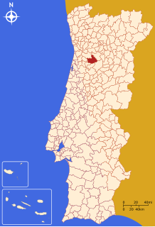
 Portugal
 (2011)
June 29
São Pedro do Sul (Portuguese pronunciation: [sɐ̃w ˈpeðɾu ðu ˈsul] ⓘ) is a municipality in the Central Portuguese district of Viseu. Part of the subregion of Dão-Lafões, the municipality has a population of 16,851 inhabitants and includes 14 civil parishes. The seat of this municipality is the city of São Pedro do Sul, with a population of 5,728 inhabitants.
History
Pre-Roman
One of the oldest monuments of the region is the "Pedra Escrita" that is a written granitic megalith dated from 10th century BC.
In the region there are three known "Castros". The castro is a fortified village that began to be inhabited from the 6th century BC, lacking streets with right angles and characterised by construction which is almost always circular. One of the Castros in São Pedro do Sul is Castro da Cárcoda.
Roman Era
In the region there are several Roman bridges and Roman Thermal Spas.
Middle Ages
São Pedro do Sul was the southern border of the Kingdom of Portugal at the time of the foundation of the country, being the natural border of the river Vouga.
The first King of Portugal Afonso Henriques lived in São Pedro do Sul while healing his injuries after the Battle of Badajoz.
Early Modern
The municipality was created in 1836 when the municipality of Lafões was divided, forming São Pedro do Sul and Vouzela.
Late modern and contemporary
São Pedro do Sul was elevated to the status of city on 12 June 2009.
Thermal Town
São Pedro do Sul is world famous for the thermal baths dating back to pre-Roman times.
Geography
The municipality is located in the north, along the Castro valley (southeast of Viseu), bordered in the south by Vouzela, to the south and west by Oliveira de Frades (northern section), in the west by Vale de Cambra and in the northwest by Arouca.
São Pedro do Sul is a municipality in the valley of Lafões, framed by the massifs of the sierras of Arada, Gralheira and São Macário. These massifs with green landscapes and crystalline water courses, hide many settlements. From the peak of São Macário, at 1,054 metres (3,458 ft) altitude, there are the views of the mountain range of Montemuro, Estrela and Caramulo.
| Population of the municipality of São Pedro do Sul (1849 – 2011) | ||||||||
|---|---|---|---|---|---|---|---|---|
| 1849 | 1900 | 1930 | 1960 | 1981 | 1991 | 2001 | 2011 | |
| 13 844 | 22 051 | 23 426 | 24 273 | 21 220 | 19 985 | 19 083 | 16 851 | |
The municipal holiday each year is on June 29.
Notable people
- António Correia de Oliveira (1879-1960) a poet; nominated unsuccessfully 15 times for the Nobel Prize in Literature.
- Conceição Matos (born 1936) a Portuguese communist who campaigned against the Estado Novo regime in the 1960s. She was arrested and tortured.
- Carlos Carvalhas (born 1941) a Portuguese economist, politician and former Secretary-General of the Portuguese Communist Party, 1993–2004
References
External links
- Municipality official website
Authority control databases | |
|---|---|
| International |
|
| National |
|
| Geographic |
|
 | This Viseu location article is a stub. You can help Wikipedia by expanding it. |
- v
- t
- e


