Saint-Sauveur, Quebec
City in Quebec, Canada
45°54′N 74°10′W / 45.9°N 74.17°W / 45.9; -74.17[1] Canada
 Quebec
 (2021)[3]
 13.2%
13.2%
 R-364
R-364Saint-Sauveur (French pronunciation: [sɛ̃ sovœʁ]) is a town and municipality within the Les Pays-d'en-Haut Regional County Municipality, Quebec, Canada. It is in the administrative region of Laurentides in the Laurentian mountains, located about 60 kilometres north of Montreal.
St-Sauveur is well known for its local ski areas, the biggest of which is Mont Saint-Sauveur. The ski areas market themselves jointly under the name of "Valley of Saint-Sauveur". Its proximity to Montreal, as well as its snow-making capability, night-time skiing, and après-ski establishments make St-Sauveur a popular destination for skiers.
The town was the childhood home—from about 1946 to 1960—of Canadian musicians Kate and Anna McGarrigle.
On September 11, 2002 the city was created from the merger of the village of Saint-Sauveur-des-Monts and the parish municipality of Saint-Sauveur.[4] The current director general is Jean Beaulieu. The city clerk is Normand Patrice.
Demographics
In the 2021 Census of Population conducted by Statistics Canada, Saint-Sauveur had a population of 11,580 living in 5,936 of its 7,267 total private dwellings, a change of 13.2% from its 2016 population of 10,231. With a land area of 47.62 km2 (18.39 sq mi), it had a population density of 243.2/km2 (629.8/sq mi) in 2021.[5]
Population trend:[6]
- Population in 2021: 11,580 (2006 to 2011 population change: 13.2%)
- Population in 2016: 10,231 (2006 to 2011 population change: 3.5%)
- Population in 2011: 9,881 (2006 to 2011 population change: 7.5%)
- Population in 2006: 9,191 (2001 to 2006 population change: 13.2%)
- Population in 2001: 8,122
- Saint-Sauveur (Parish): 4,806
- Saint-Sauveur-des-Monts (Village): 3,316
- Population in 1996:
- Saint-Sauveur (Parish): 3,970
- Saint-Sauveur-des-Monts (Village): 2,904
- Population in 1991:
- Saint-Sauveur (Parish): 2,719
- Saint-Sauveur-des-Monts (Village): 2,545
Mother tongue:[7]
- English as first language: 7.1%
- French as first language: 86.8%
- English and French as first language: 2%
- Other as first language: 3.5%
Education
Sir Wilfrid Laurier School Board operates Anglophone public schools:
- Morin Heights Elementary School in Morin-Heights[8]
- Laurentian Regional High School in Lachute[9]
Notable residents
- Frédéric Allard, ice hockey player
- Omer Létourneau, organist, composer and conductor[10]
- Kate and Anna McGarrigle, singer/songwriter duo
- Chris Ramsay, Canadian magician and YouTuber
Mayors
- Georges Filion - 2002–2005
- Michel Lagacé - 2005–2013
- Jacques Gariépy - 2013–present
The first mayor of Saint-Sauveur was William Henry Scott, who took office in 1855 when the parish municipality was incorporated. The parish had 21 mayors from 1855 to 2002. The village of Saint-Sauveur-des-Monts was carved out of the parish municipality in 1926 and thereafter had its own council and mayor.[11]
Images
-
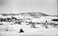 Saint-Sauveur-des-Monts in 1942
 -
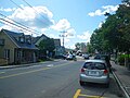 Rue Principale
 -
 Saint-Sauveur Village
 -
 Church in Saint-Sauveur


See also
References
- ^ "Banque de noms de lieux du Québec: Reference number 377892". toponymie.gouv.qc.ca (in French). Commission de toponymie du Québec.
- ^ a b "Saint-Sauveur". Répertoire des municipalités (in French). Ministère des Affaires municipales, des Régions et de l'Occupation du territoire. Archived from the original on 2012-05-01. Retrieved 2011-06-22.
- ^ a b Statistics Canada Census, 2021 Census Profiles: Saint-Sauveur
- ^ "Archived copy" (PDF). stat.gouv.qc.ca. Archived from the original (PDF) on 30 December 2006. Retrieved 22 May 2022.
{{cite web}}: CS1 maint: archived copy as title (link) - ^ "Population and dwelling counts: Canada, provinces and territories, and census subdivisions (municipalities), Quebec". Statistics Canada. February 9, 2022. Retrieved August 29, 2022.
- ^ Statistics Canada: 1996, 2001, 2006, 2011, 2016, 2021 census
- ^ Statistics Canada Census, 2021 Community Profiles: Saint-Sauveur
- ^ "MORIN HEIGHTS ELEMENTARY ZONE Archived 2017-09-16 at the Wayback Machine." Sir Wilfrid Laurier School Board. Retrieved on September 16, 2017.
- ^ "LAURENTIAN REGIONAL HS ZONE Archived 2010-12-14 at the Wayback Machine." Sir Wilfrid Laurier School Board. Retrieved on September 4, 2017.
- ^ Le Passe-temps. Vol. 53-54. Editions du Passe-temps.; 1947.
- ^ "City Hall and First Mayors of Saint-Sauveur sur BaladoDécouverte". baladodecouverte.com. Retrieved 2021-10-22.
External links
Wikimedia Commons has media related to Saint-Sauveur, Quebec.
- City of Saint-Sauveur website
- Valley of Saint-Sauveur Ski Resorts
- Saint-Sauveur business and tourism
- Directory of lodging, restaurants and activities
- Photo Gallery Saint-Sauveur, Quebec, Canada
- Forum Directory and News for Saint-Sauveur, Quebec, Canada
Places adjacent to Saint-Sauveur, Quebec | ||||||||||||||||
|---|---|---|---|---|---|---|---|---|---|---|---|---|---|---|---|---|
| ||||||||||||||||


- v
- t
- e
 Subdivisions of Les Pays-d'en-Haut Regional County Municipality
- Estérel
- Sainte-Adèle
- Sainte-Marguerite-du-Lac-Masson
- Saint-Sauveur
- Regional County Municipalities in Laurentides:
Antoine-Labelle - Argenteuil
- Deux-Montagnes
- La Rivière-du-Nord
- Les Laurentides
- Les Pays-d'en-Haut
- Thérèse-De Blainville
- Independent Cities: Mirabel
- Native Reserves: Doncaster
- Kanesatake
Authority control databases | |
|---|---|
| International |
|
| National |
|
| Geographic |
|


