Saku Parish
Saku vald | |
|---|---|
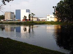
 Saku brewery | |
 Saku Parish within Harju County. | |
| Country | |
| County | |
| Administrative centre | Saku |
| Government | |
| • Mayor | Kuno Rooba |
| Area | |
• Total | 171.13 km2 (66.07 sq mi) |
| Population (2006) | |
• Total | 8,031 |
| • Density | 47/km2 (120/sq mi) |
| ISO 3166 code | EE-719 |
| Website | www.sakuvald.ee |
Saku Parish (Estonian: Saku vald) is a rural municipality in Harju County, north-western Estonia.
The administrative centre of Saku Parish is Saku; a small town with population of 4,618 (as of 2005). It is situated 10 km south of Estonia's capital, Tallinn.
History
[edit]Established in 1866.
Awarded the Japanese Foreign Minister’s Commendation for their contributions to promotion of mutual understanding between Estonia and Japan on December 1, 2020.[1][2]
Local government
[edit]Current chairman of the council (est: volikogu esimees) is Eero Alamaa.
As of 2018, the mayor (est: vallavanem) is Marti Rehemaa.
Religion
[edit]- Unaffiliated (80.7%)
- Lutheran (10.5%)
- Orthodox (2.90%)
- Others Christians (3.10%)
- Others Religions or Unknown (2.80%)
- 0.00%
Geography
[edit]
Populated places
[edit]There are 2 small towns (est: alevikud, sg. alevik) and 19 villages (est: külad, sg. küla) in Saku Parish.
Villages: Jälgimäe, Juuliku, Kajamaa, Kasemetsa, Kirdalu, Kurtna, Lokuti, Männiku, Metsanurme, Rahula, Roobuka, Saue, Saustinõmme, Sookaera-Metsanurga, Tänassilma, Tagadi, Tammemäe, Tõdva, Üksnurme.
Sport
[edit]Kurtna is home to Bandy Federation of Estonia:[2]
References
[edit]External links
[edit]- Official website

- Maps of Saku Parish Archived 2012-08-06 at the Wayback Machine

