San Pablo de Borbur

Municipality and town in Boyacá Department, Colombia
Flag of San Pablo de Borbur
Flag
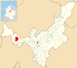
Location of the municipality and town of San Pablo de Borbur in the Boyacá Department of Colombia.
Country ColombiaDepartmentBoyacá DepartmentProvinceWestern Boyacá ProvinceGovernment
 • MayorNeyder Mauricio Obando Forero
(2020-2023)Elevation
830 m (2,720 ft)Population
 (Census 2018[1])
 • Total5,839Time zoneUTC-5 (Colombia Standard Time)

San Pablo de Borbur is a town and municipality in the Colombian Department of Boyacá, part of the subregion of the Western Boyacá Province. The three most important productive sectors are agriculture, livestock and mining, with the emerald being one of the representative elements of the region.


References

  1. ^ "Censo Nacional de Población y Vivienda 2018" (in Spanish). DANE. Retrieved 10 May 2020.

External links

Wikimedia Commons has media related to San Pablo de Borbur.
  • v
  • t
  • e
Provinces and Municipalities in Boyacá Department Flag of Boyacá
Central Boyacá Province
Northern Boyacá ProvinceWestern Boyacá ProvinceEastern Boyacá ProvinceGutiérrez ProvinceLa Libertad ProvinceLengupá ProvinceMárquez ProvinceNeira ProvinceRicaurte ProvinceSugamuxi ProvinceTundama ProvinceValderrama ProvinceBoyacá Frontier DistrictBoyacá Special Handling Zone
  • v
  • t
  • e
Gold
San Pablo de Borbur is located in Colombia
San Pablo de Borbur
San Pablo de Borbur
San Pablo de Borbur
San Pablo de Borbur
San Pablo de Borbur
San Pablo de Borbur
San Pablo de Borbur
San Pablo de Borbur
San Pablo de Borbur
San Pablo de Borbur
San Pablo de Borbur
San Pablo de Borbur
San Pablo de Borbur
Silver
Platinum
Nickel
Coltan
Emeralds
Coal
Salt
Sources
  • Gold • Silver • Platinum • Nickel • Coltan • Emeralds • Coal • Salt
Category • Images
  • v
  • t
  • e
Colombian emeralds
Geology
History
Pre-Columbian
Conquest
Main mining areas
Western Belt
Eastern Belt
Individual mines
  • Muzo
  • Coscuez
  • Chivor
  • Las Pavas
  • La Pita
  • Peñas Blancas
  • Cunas
  • Polveros
  • Tequendama
  • Agua Blanca
  • Buenavista
  • Cincho
  • Gualí
  • Matacana
  • Palo Aranado
  • La Polvorosa
  • Yacopí
Individual emeralds (ct)
Related articles
  • Category
  • Images

5°45′N 74°05′W / 5.750°N 74.083°W / 5.750; -74.083

Stub icon

This Boyacá Department location article is a stub. You can help Wikipedia by expanding it.

  • v
  • t
  • e