San Pedro Carchá
Municipality in Alta Verapaz, Guatemala

Flag

Coat of arms
Carchá
 Guatemala
 Alta Verapaz
 (Census 2018)[1]
San Pedro Carchá, usually referred to as Carchá, is a town and a municipality in the Guatemalan department of Alta Verapaz. The municipality covers an area of 1,310 km2 (510 sq mi) and is situated at 1,282 m above sea level.[2]
At the 2018 census, the population of the municipality was 235,275 and that of the town of Carchá was 16,353.[3][4]
Sports
Deportivo Carchá football club play their home games in the Estadio Juan Ramon Ponce Guay. They have played in Guatemala's top division from 1998 to 2001.[citation needed]
Franja Transversal del Norte


San Pedro Carchá
class=notpageimage|
Location of San Pedro Carchá in Franja Transversal del NorteThe Northern Transversal Strip was officially created during the government of General Carlos Arana Osorio in 1970, by Legislative Decree 60–70, for agricultural development.[5] The decree literally said: "It is of public interest and national emergency, the establishment of Agrarian Development Zones in the area included within the municipalities: San Ana Huista, San Antonio Huista, Nentón, Jacaltenango, San Mateo Ixtatán, and Santa Cruz Barillas in Huehuetenango; Chajul and San Miguel Uspantán in Quiché; Cobán, Chisec, San Pedro Carchá, Lanquín, Senahú, Cahabón and Chahal, in Alta Verapaz and the entire department of Izabal."[6]
Climate
San Pedro Carchá has a warm and temperate climate (Köppen: Cfb).
| Climate data for San Pedro Carchá | |||||||||||||
|---|---|---|---|---|---|---|---|---|---|---|---|---|---|
| Month | Jan | Feb | Mar | Apr | May | Jun | Jul | Aug | Sep | Oct | Nov | Dec | Year |
| Daily mean °C (°F) | 16.5 (61.7) | 17.4 (63.3) | 18.7 (65.7) | 19.7 (67.5) | 20.4 (68.7) | 20.4 (68.7) | 20.0 (68.0) | 20.0 (68.0) | 20.0 (68.0) | 19.0 (66.2) | 18.0 (64.4) | 16.9 (62.4) | 18.9 (66.1) |
| Average precipitation mm (inches) | 128 (5.0) | 99 (3.9) | 111 (4.4) | 105 (4.1) | 183 (7.2) | 309 (12.2) | 266 (10.5) | 238 (9.4) | 306 (12.0) | 318 (12.5) | 235 (9.3) | 146 (5.7) | 2,444 (96.2) |
| Source: Climate-Data.org[7] | |||||||||||||
Geographic location
San Pedro Carchá is completely surrounded by Alta Verapaz department municipalities:
- v
- t
- e
Places adjacent to San Pedro Carchá
| Chisec | Fray Bartolomé de las Casas[8] | |
 | ||
| Cobán |  San Pedro Carchá San Pedro Carchá | Cahabón, Lanquín and Senahú[8] |
 | ||
| San Juan Chamelco[8] |
Gallery
-
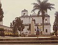 San Pedro Carcha Church

Notes and references
 Guatemala portal
 Geography portal


References
- ^ "Guatemala: Administrative Division (Departments and Municipalities) - Population Statistics, Charts and Map". www.citypopulation.de. Retrieved 2024-06-14.
- ^ "San Pedro Carchá - Ubicación". inforpressca.com. Retrieved 2009-10-01.
- ^ "San Pedro Carchá". inforpressca.com. Retrieved 2009-10-01.
- ^ "Guatemala: Departments, Major Cities & Towns - Population Statistics, Maps, Charts, Weather and Web Information". www.citypopulation.de. Retrieved 2024-06-14.
- ^ "Franja Transversal del Norte". Wikiguate. Guatemala. Archived from the original on 31 October 2014. Retrieved 30 October 2014.
- ^ Solano 2012, p. 15.
- ^ "Climate: San Pedro Carchá". Climate-Data.org. Retrieved 19 August 2015.
- ^ a b c SEGEPLAN. "Municipios de Alta Verapaz, Guatemala". Secretaría General de Planificación y Programación de la Presidencia de la República. Guatemala. Archived from the original on 30 June 2015. Retrieved 30 June 2015.
Bibliography
- Solano, Luis (2012). "Contextualización histórica de la Franja Transversal del Norte (FTN)" (PDF). Centro de Estudios y Documentación de la Frontera Occidental de Guatemala, CEDFOG (in Spanish). Retrieved 31 October 2014.
External links
 Media related to San Pedro Carchá at Wikimedia Commons
- Muni in Spanish
| ||
|---|---|---|
Capital: Cobán | ||
| Municipalities | 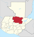 | |

| ||
|---|---|---|
| Departments in the region | ||
| Major rivers and lakes |
| |
| International corporation in the area | ||
| Civil War events | ||
| Presidents of Guatemala related to the region | ||
Authority control databases | |
|---|---|
| International |
|
| National |
|
15°28′N 90°18′W / 15.467°N 90.300°W / 15.467; -90.300


