Sankt Peter, Baden-Württemberg
You can help expand this article with text translated from the corresponding article in German. (February 2009) Click [show] for important translation instructions.
- View a machine-translated version of the German article.
- Machine translation, like DeepL or Google Translate, is a useful starting point for translations, but translators must revise errors as necessary and confirm that the translation is accurate, rather than simply copy-pasting machine-translated text into the English Wikipedia.
- Do not translate text that appears unreliable or low-quality. If possible, verify the text with references provided in the foreign-language article.
- You must provide copyright attribution in the edit summary accompanying your translation by providing an interlanguage link to the source of your translation. A model attribution edit summary is
Content in this edit is translated from the existing German Wikipedia article at [[:de:St. Peter (Hochschwarzwald)]]; see its history for attribution. - You may also add the template
{{Translated|de|St. Peter (Hochschwarzwald)}}to the talk page. - For more guidance, see Wikipedia:Translation.
Municipality in Baden-Württemberg, Germany

Coat of arms
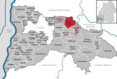
Location of St. Peter within Breisgau-Hochschwarzwald district
(2016–24) Rudolf Schuler[1] (Ind.)
(2022-12-31)[2]
79271
Sankt Peter is a municipality in the district of Breisgau-Hochschwarzwald in Baden-Württemberg in Germany.
Geography
Location
St. Peter is a climatic spa located within the Southern Black Forest Nature Park, on the southern flank of the Kandel, about 12 miles east of Freiburg im Breisgau.
Administrative structure
To the municipality of St. Peter belong the village of Bürgerschaft, the hamlet of Sägendobel, the settlements of Kandelberg, Neuwelt, Oberibental, Ränke, Rohr, Schmittenbach, Schönhöfe, Seelgut and Willmendobel and the farmsteads of Eckpeterhof, Langeck and Lindlehof.
History
The Abbey of St. Peter in the Black Forest was founded in 1093 by the Duke of Zähringen, Berthold II as his house abbey and family burial site. The municipality developed gradually over time around the abbey.
When the estates of the Church were seized and sold or transferred during Napoleon's conquest of Europe, the village of St. Peter was handed to the Grand Duchy of Baden in 1806 and, since 1952, they have been part of the state of Baden-Württemberg.
In 1899, fire broke out in the village centre of St. Peter,[3] whereupon 23 houses were destroyed and 150 people made homeless.[4]
At the end of the Second World War there was a Reich training centre of the Hitler Youth in St. Peter.[5]
| Population growth | ||||||||||||||
|---|---|---|---|---|---|---|---|---|---|---|---|---|---|---|
| Year | 1806 | 1871 | 1900 | 1925 | 1939 | 1950 | 1961 | 1970 | 1989 | 1995 | 2005 | 2010 | 2015 | |
| Population | 1480 | 1308 | 1383 | 1378 | 1426 | 1500 | 1529 | 1797 | 2207 | 2362 | 2508 | 2547 | 2583 | |
Source: Statistisches Landesamt Baden-Württemberg (except 1806); 1871–1970: Census results
Gallery
-
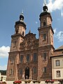 The abbey church of St. Peter and St. Paul
 -
 Gateway to the abbey courtyard (Klosterhof)
 -
 Steyrer Strasse
 -
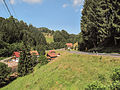 Panorama between Sankt Peter and the Glottertal valley


References
- ^ Aktuelle Wahlergebnisse, Staatsanzeiger, accessed 11 September 2021.
- ^ "Bevölkerung nach Nationalität und Geschlecht am 31. Dezember 2022" [Population by nationality and sex as of December 31, 2022] (CSV) (in German). Statistisches Landesamt Baden-Württemberg. June 2023.
- ^ Karl Schmid; Hans Schadek: Die Zähringer. Anstoß und Wirkung. Thorbecke, Sigmaringen 1986, ISBN 3-7995-7041-1, p. 371
- ^ Chronicle of the Municipality of St. Peter
- ^ Arbeitsgemeinschaft Ebringer Dorfgeschichte (publ.): Ebringer Dorfgeschichte Nr. 2. Ebringen unterm Hakenkreuz. Zeitzeugenberichte, Ebringen 2008, pp. 33 and 38
External links
Wikimedia Commons has media related to St. Peter (Hochschwarzwald).
- (in German) St. Peter: History and images
- (in German) St. Peter
- v
- t
- e
Towns and municipalities in Breisgau-Hochschwarzwald (district)
- Au
- Auggen
- Badenweiler
- Bad Krozingen
- Ballrechten-Dottingen
- Bötzingen
- Bollschweil
- Breisach
- Breitnau
- Buchenbach
- Buggingen
- Ebringen
- Ehrenkirchen
- Eichstetten am Kaiserstuhl
- Eisenbach
- Eschbach
- Feldberg
- Friedenweiler
- Glottertal
- Gottenheim
- Gundelfingen
- Hartheim am Rhein
- Heitersheim
- Heuweiler
- Hinterzarten
- Horben
- Ihringen
- Kirchzarten
- Lenzkirch
- Löffingen
- March
- Merdingen
- Merzhausen
- Müllheim
- Münstertal
- Neuenburg am Rhein
- Oberried
- Pfaffenweiler
- Schallstadt
- Schluchsee
- Sölden
- Sankt Märgen
- Sankt Peter
- Staufen
- Stegen
- Sulzburg
- Titisee-Neustadt
- Umkirch
- Vogtsburg
- Wittnau

Authority control databases | |
|---|---|
| International |
|
| National |
|
| Geographic |
|
 | This Breisgau-Hochschwarzwald location article is a stub. You can help Wikipedia by expanding it. |
- v
- t
- e


