Santol, La Union
Municipality in La Union, Philippines
Municipality in Ilocos Region, Philippines

Flag

Seal
Isem Metru Santol

Map of La Union with Santol highlighted
Members
- Jojo O. Ominga
- Claudio O. Galos Jr.
- Edith R. Millares
- William O. Agtarap
- Olympio O. Millares
- Loreto A. Wailan
- Roxanne M. Dangle
- Tirso A. Ledda
(2020 census)[3]
5.31
2505
013318000
Tagalog
Santol, officially the Municipality of Santol (Ilocano: Ili ti Santol; Filipino: Bayan ng Santol), is a 4th class municipality in the province of La Union, Philippines. According to the 2020 census, it has a population of 14,166 people.[3]
Geography
Santol is situated in the north-eastern part of the Province of La Union. It is bounded on the north by the Municipality of Sudipen, on the north-east by the upland Municipality of Sugpon in Ilocos Sur, on the south by the Municipality of San Gabriel, and on the west by the Municipality of Balaoan. The town center of Santol is 40 kilometres (25 mi) north of the City of San Fernando, the provincial capital and regional administrative center; 310 kilometres (190 mi) north of Manila and 113 kilometres (70 mi) of the country's summer capital Baguio via the Naguilian Road.
Barangays
Santol is politically subdivided into 11 barangays. [5] Each barangay consists of puroks and some have sitios.
- Corrooy
- Lettac Norte
- Lettac Sur
- Mangaan
- Paagan
- Poblacion
- Puguil
- Ramot
- Sapdaan
- Sasaba
- Tubaday
Climate
| Climate data for Santol, La Union | |||||||||||||
|---|---|---|---|---|---|---|---|---|---|---|---|---|---|
| Month | Jan | Feb | Mar | Apr | May | Jun | Jul | Aug | Sep | Oct | Nov | Dec | Year |
| Mean daily maximum °C (°F) | 30 (86) | 31 (88) | 32 (90) | 33 (91) | 32 (90) | 31 (88) | 30 (86) | 29 (84) | 30 (86) | 31 (88) | 31 (88) | 30 (86) | 31 (88) |
| Mean daily minimum °C (°F) | 21 (70) | 22 (72) | 23 (73) | 25 (77) | 26 (79) | 25 (77) | 25 (77) | 25 (77) | 25 (77) | 24 (75) | 23 (73) | 21 (70) | 24 (75) |
| Average precipitation mm (inches) | 42 (1.7) | 48 (1.9) | 74 (2.9) | 110 (4.3) | 269 (10.6) | 275 (10.8) | 362 (14.3) | 325 (12.8) | 330 (13.0) | 306 (12.0) | 126 (5.0) | 61 (2.4) | 2,328 (91.7) |
| Average rainy days | 11.2 | 12.0 | 17.1 | 21.2 | 27.1 | 26.8 | 28.1 | 27.0 | 26.0 | 24.5 | 17.7 | 12.4 | 251.1 |
| Source: Meteoblue[6] | |||||||||||||
Demographics
| Year | Pop. | ±% p.a. |
|---|---|---|
| 1918 | 3,536 | — |
| 1939 | 4,901 | +1.57% |
| 1948 | 5,060 | +0.36% |
| 1960 | 6,125 | +1.60% |
| 1970 | 7,316 | +1.79% |
| 1975 | 7,686 | +0.99% |
| 1980 | 7,836 | +0.39% |
| 1990 | 9,544 | +1.99% |
| 1995 | 10,209 | +1.27% |
| 2000 | 11,202 | +2.01% |
| 2007 | 11,712 | +0.62% |
| 2010 | 12,007 | +0.91% |
| 2015 | 12,476 | +0.73% |
| 2020 | 14,166 | +2.53% |
| Source: Philippine Statistics Authority[7][8][9][10] | ||
In the 2020 census, the population of Santol, La Union, was 14,166 people,[3] with a density of 150 inhabitants per square kilometre or 390 inhabitants per square mile.
Economy
Poverty Incidence of Santol
Graphs are unavailable due to technical issues. There is more info on Phabricator and on MediaWiki.org. |
Government
Local government
Santol, belonging to the first congressional district of the province of La Union, is governed by a mayor designated as its local chief executive and by a municipal council as its legislative body in accordance with the Local Government Code. The mayor, vice mayor, and the councilors are elected directly by the people through an election which is being held every three years.
Elected officials
| Position | Name |
|---|---|
| Congressman | Pablo C. Ortega |
| Mayor | Magno A. Wailan |
| Vice-Mayor | Monico O. Oriente Jr. |
| Councilors | Jojo O. Ominga |
| Claudio O. Galos Jr. | |
| Edith R. Millares | |
| William O. Agtarap | |
| Olympio O. Millares | |
| Loreto A. Wailan | |
| Roxanne M. Dangle | |
| Tirso A. Ledda |
Gallery
-
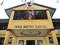 Municipal hall
 -
 Town center
 -
 Town center
 -
 Our Lady of Victory Church
 -
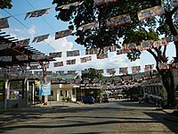
 Street view and landscape


References
- ^ Municipality of Santol | (DILG)
- ^ "2015 Census of Population, Report No. 3 – Population, Land Area, and Population Density" (PDF). Philippine Statistics Authority. Quezon City, Philippines. August 2016. ISSN 0117-1453. Archived (PDF) from the original on May 25, 2021. Retrieved July 16, 2021.
- ^ a b c Census of Population (2020). "Region I (Ilocos Region)". Total Population by Province, City, Municipality and Barangay. Philippine Statistics Authority. Retrieved 8 July 2021.
- ^ "PSA Releases the 2018 Municipal and City Level Poverty Estimates". Philippine Statistics Authority. 15 December 2021. Retrieved 22 January 2022.
- ^ "Province: La Union". PSGC Interactive. Quezon City, Philippines: Philippine Statistics Authority. Retrieved 12 November 2016.
- ^ "Santol: Average Temperatures and Rainfall". Meteoblue. Retrieved 26 April 2020.
- ^ Census of Population (2015). "Region I (Ilocos Region)". Total Population by Province, City, Municipality and Barangay. Philippine Statistics Authority. Retrieved 20 June 2016.
- ^ Census of Population and Housing (2010). "Region I (Ilocos Region)" (PDF). Total Population by Province, City, Municipality and Barangay. National Statistics Office. Retrieved 29 June 2016.
- ^ Censuses of Population (1903–2007). "Region I (Ilocos Region)". Table 1. Population Enumerated in Various Censuses by Province/Highly Urbanized City: 1903 to 2007. National Statistics Office.
{{cite encyclopedia}}: CS1 maint: numeric names: authors list (link) - ^ "Province of La Union". Municipality Population Data. Local Water Utilities Administration Research Division. Retrieved 17 December 2016.
- ^ "Poverty incidence (PI):". Philippine Statistics Authority. Retrieved December 28, 2020.
- ^ "Estimation of Local Poverty in the Philippines" (PDF). Philippine Statistics Authority. 29 November 2005.
- ^ "2003 City and Municipal Level Poverty Estimates" (PDF). Philippine Statistics Authority. 23 March 2009.
- ^ "City and Municipal Level Poverty Estimates; 2006 and 2009" (PDF). Philippine Statistics Authority. 3 August 2012.
- ^ "2012 Municipal and City Level Poverty Estimates" (PDF). Philippine Statistics Authority. 31 May 2016.
- ^ "Municipal and City Level Small Area Poverty Estimates; 2009, 2012 and 2015". Philippine Statistics Authority. 10 July 2019.
- ^ "PSA Releases the 2018 Municipal and City Level Poverty Estimates". Philippine Statistics Authority. 15 December 2021. Retrieved 22 January 2022.
- ^ "2019 National and Local Elections" (PDF). Commission on Elections. Retrieved March 6, 2022.
External links
Wikimedia Commons has media related to Santol, La Union.
- Philippine Standard Geographic Code
- Philippine Census Information
- Local Governance Performance Management System
Places adjacent to Santol, La Union | |
|---|---|


