Saspochey | |
|---|---|
Village | |
 Saspochey Location in Ladakh, India  Saspochey Saspochey (India) | |
| Coordinates: 34°18′42″N 77°09′49″E / 34.3116964°N 77.1636148°E | |
| Country | India |
| Union Territory | Ladakh |
| District | Leh |
| Tehsil | Likir[1] |
| Elevation | 3,712 m (12,178 ft) |
| Population (2011) | |
• Total | 214 |
| Time zone | UTC+5:30 (IST) |
| 2011 census code | 949 |
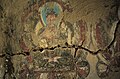
Saspochey is a village in the Leh district of Ladakh, India.[2] It is located in the Likir tehsil. One of the early period temples with paintings that may be dated to late 12th century is located here.[3] The paintings are in a very bad state of preservation, with only two walls and a small portion of the remaining two walls having surviving paintings.
Wooden sculptures (possibly dating before 12th century CE) are also stored inside this temple.[4]
Demographics
[edit]According to the 2011 census of India, Saspochey has 36 households. The effective literacy rate (i.e. the literacy rate of population excluding children aged 6 and below) is 75%.[5]
| Total | Male | Female | |
|---|---|---|---|
| Population | 214 | 99 | 115 |
| Children aged below 6 years | 34 | 16 | 18 |
| Scheduled caste | 0 | 0 | 0 |
| Scheduled tribe | 214 | 99 | 115 |
| Literates | 135 | 74 | 61 |
| Workers (all) | 90 | 47 | 43 |
| Main workers (total) | 36 | 27 | 9 |
| Main workers: Cultivators | 0 | 0 | 0 |
| Main workers: Agricultural labourers | 0 | 0 | 0 |
| Main workers: Household industry workers | 0 | 0 | 0 |
| Main workers: Other | 36 | 27 | 9 |
| Marginal workers (total) | 54 | 20 | 34 |
| Marginal workers: Cultivators | 23 | 9 | 14 |
| Marginal workers: Agricultural labourers | 10 | 4 | 6 |
| Marginal workers: Household industry workers | 5 | 0 | 5 |
| Marginal workers: Others | 16 | 7 | 9 |
| Non-workers | 124 | 52 | 72 |
Art Works
[edit]Paintings and Sculptures inside the temple at Saspochey.
-
 Painting 1
 -
 Painting2
 -
 Painting 3
 -
 Painting 4


-
 Sculptures 1
 -
 Sculptures 2


References
[edit]- ^ "Villages | District Leh, Union Territory of Ladakh | India".
- ^ "Blockwise Village Amenity Directory" (PDF). Ladakh Autonomous Hill Development Council. Retrieved 23 July 2015.
- ^ "Saspotse".
- ^ "Saspotse | ArchResearch". archresearch.tugraz.at. Retrieved 24 December 2019.
- ^ a b "Leh district census". 2011 Census of India. Directorate of Census Operations. Retrieved 23 July 2015.
| State symbols | |||||||||||||||||||
|---|---|---|---|---|---|---|---|---|---|---|---|---|---|---|---|---|---|---|---|
| History |
| ||||||||||||||||||
| Administration | |||||||||||||||||||
| Geography |
| ||||||||||||||||||
| Human settlements | |||||||||||||||||||
| Culture |
| ||||||||||||||||||
| Tourism and wildlife |
| ||||||||||||||||||
| Transport |
| ||||||||||||||||||
| Infrastructure |
| ||||||||||||||||||
| See also |
| ||||||||||||||||||