Schwerin, Brandenburg
Municipality in Brandenburg, Germany
Location of Schwerin within Dahme-Spreewald district

(2019–24) Heinz Gode[1]
(2022-12-31)[2]
15755
Schwerin is a municipality in the district of Dahme-Spreewald in Brandenburg in Germany.
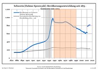
Demography
|
|
|
References
- ^ Landkreis Dahme-Spreewald Wahl der Bürgermeisterin / des Bürgermeisters, accessed 30 June 2021.
- ^ "Bevölkerungsentwicklung und Bevölkerungsstandim Land Brandenburg Dezember 2022" (PDF). Amt für Statistik Berlin-Brandenburg (in German). June 2023.
- ^ Detailed data sources are to be found in the Wikimedia Commons.Population Projection Brandenburg at Wikimedia Commons
- v
- t
- e
Towns and municipalities in Dahme-Spreewald
- Alt Zauche-Wußwerk
- Bersteland
- Bestensee
- Byhleguhre-Byhlen/Běła Góra-Bělin
- Drahnsdorf
- Eichwalde
- Golßen
- Groß Köris
- Halbe
- Heideblick
- Heidesee
- Jamlitz
- Kasel-Golzig
- Königs Wusterhausen
- Krausnick-Groß Wasserburg
- Lieberose
- Lübben (Spreewald)/Lubin (Błota)
- Luckau
- Märkisch Buchholz
- Märkische Heide
- Mittenwalde
- Münchehofe
- Neu Zauche/Nowa Niwa
- Rietzneuendorf-Staakow
- Schlepzig
- Schönefeld
- Schönwald
- Schulzendorf
- Schwerin
- Schwielochsee
- Spreewaldheide
- Steinreich
- Straupitz (Spreewald)/Tšupc (Błota)
- Teupitz
- Unterspreewald
- Wildau
- Zeuthen

Authority control databases | |
|---|---|
| National |
|
| Geographic |
|
 | This Brandenburg location article is a stub. You can help Wikipedia by expanding it. |
- v
- t
- e


