Seaspray, Victoria
Town in Victoria, Australia
38°23′00″S 147°10′00″E / 38.38333°S 147.16667°E / -38.38333; 147.16667- 242 km (150 mi) east of Melbourne
- 34 km (21 mi) south of Sale
- 62 km (39 mi) north east of Yarram
Seaspray is a small coastal town in Victoria, Australia, in the Gippsland region of the state. The town is located alongside the Ninety Mile Beach about 10 kilometres (6.2 mi) off the South Gippsland Highway in the Shire of Wellington, 242 kilometres (150 mi) east of the state capital, Melbourne.
At the 2016 census, Seaspray had a population of 322.[1]
Seaspray's main recreational features and tourism attractions focus around swimming, surfing and other watersports, as well as fishing on the Ninety Mile Beach. There is also fishing in the creek, walks, tennis, picnic and playground facilities, and regular markets.[3][4]
Especially in winter, southern right whales may provide onlookers chances to witness them cavorting close to shores.[5]
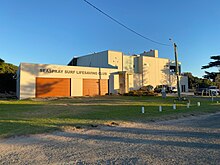
The town is home to a Surf Life Saving Club and hosts annual Surf Life Saving Carnivals.[3][4] In 2015 the Seaspray Surf Life Saving Club underwent a $2.6 million rebuild after the previous club rooms had been badly damaged by violent storms in 2007. This first stage of the rebuild included better operational control facilities, a first-aid centre, equipment storage, and a social function area with views across the town and beach. Future stages of the work will include a patrol tower, extensive outside decking to expand the function area, and greater storage facilities.[6]
-
 Looking across the Coastal Reserve to the town from near the Surf Life Saving Club
 -
 The Surf Life Saving Club, first stage rebuilt in 2015 at a cost of $2.6 million
 -
 North-east along the Ninety Mile Beach
 -
 The SLSC as seen from the road
 -
 Outdoor seating at the SLSC


History
In 1943, 7 people were injured at Seaspray Beach after a wire attached to an RAAF plane failed to retract.[7]
Seaspray hosted an overnight's stay of the Great Victorian Bike Ride on its seventh running in 1990 and again in 2017.[8]
References
- ^ a b "2016 Census QuickStats: Seaspray". Official site. Australian Bureau of Statistics. 23 October 2017. Retrieved 2 May 2019.
- ^ "Seaspray Demographics (VIC) Local Stats". Qpzm LocalStats. Qpzm. Retrieved 8 January 2013.
- ^ a b "SEASPRAY information & attractions". Travel Victoria. Retrieved 8 January 2013.
- ^ a b "Seaspray Victoria Australia". Gippsland and Beyond. Retrieved 8 January 2013.
- ^ Gippsland Times. 2017. Whales off Seaspray. Retrieved on September 06, 2017
- ^ "Seaspray SLSC work begins". Gippsland Times. Fairfax Media. 16 February 2015. Retrieved 23 June 2016.
- ^ "Shocking Accident at Seaspray". The Age. 28 December 1943. Retrieved 8 May 2021.
A target attached by a wire to an R.A.A.F. plane, which was flying at a low level, struck a group of people on the beach.
- ^ "History of the Great Victorian Bike Ride". Official site. Bicycle Network Victoria. Archived from the original on 10 January 2013. Retrieved 27 December 2012.
Wikivoyage has a travel guide for Seaspray.
Wikimedia Commons has media related to Seaspray, Victoria.
- v
- t
- e
Localities in the Shire of Wellington

- Alberton
- Boisdale
- Briagolong
- Bundalaguah
- Cobains
- Coongulla
- Cowwarr^
- Denison
- Devon North
- East Sale
- Fulham
- Glengarry^
- Glenmaggie
- Golden Beach
- Gormandale
- Heyfield
- Loch Sport
- Longford
- Maffra
- Nambrok
- Newry
- Port Albert
- Rosedale
- Seaspray
- Stratford
- Tinamba
- Toongabbie^
- Woodside
- Wurruk
- Yarram
- Airly
- Alberton West
- Arbuckle
- Balook^
- Billabong
- Binginwarri^
- Blackwarry
- Budgee Budgee
- Buragwonduc
- Bushy Park
- Callignee North
- Callignee South
- Calrossie
- Carrajung
- Carrajung Lower
- Carrajung South
- Clydebank
- Cowa
- Crookayan
- Crooked River
- Dargo^
- Darriman
- Dawson
- Dutson
- Dutson Downs
- Fernbank^
- Flamingo Beach
- Flynn^
- Flynns Creek^
- Gelliondale
- Giffard
- Giffard West
- Gillum
- Glenfalloch
- Glomar Beach
- Grand Ridge^
- Hawkhurst
- Hedley^
- Hiamdale
- Hiawatha
- Hollands Landing
- Howitt Plains
- Hunterston
- Jack River
- Kilmany
- Koorool
- Lake Wellington
- Langsborough
- Licola
- Licola North
- Llowalong
- Macks Creek
- Madalya
- Maffra West Upper
- Manns Beach
- McLoughlins Beach
- Meerlieu
- Miowera
- Monomak
- Montgomery
- Moornapa
- Moroka
- Munro
- Myrtlebank
- Nap Nap Marra
- Ocean Grange^
- Paradise Beach
- Pearsondale
- Perry Bridge
- Reynard^
- Riverslea
- Robertsons Beach
- Sargood
- Seacombe
- Seaton
- Snake Island
- Staceys Bridge
- Stockdale
- Stradbroke
- Tamboritha
- Tarra Valley
- Tarraville
- The Heart
- The Honeysuckles
- Tinamba West
- Toolome
- Valencia Creek
- Walhalla^
- Walhalla East
- Willung
- Willung South
- Winnindoo
- Won Wron
- Wongungarra^
- Wonyip
- Woodside Beach
- Woodside North
- Woolenook
- Worrowing
- Wrathung
- Wrixon
- Yangoura
^ - Territory divided with another LGA
 | This article about a location in Gippsland (region) is a stub. You can help Wikipedia by expanding it. |
- v
- t
- e


