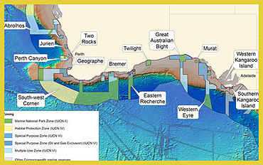
South-west Corner Marine Park
Marine protected area off Western Australia
34°06′39″S 121°01′25″E / 34.1108°S 121.0237°E / -34.1108; 121.0237[1]
The South-west Corner Marine Park (formerly South-west Corner Commonwealth Marine Reserve)[3] is a marine protected area on the lower south west and southern coast of Western Australia, one of 14 in the South-west Marine Parks Network.[4]
It was gazetted in 14 December 2013 and was renamed on 11 October 2017.[5][2]
Features
The key ecological features of the marine park include:
- Albany Canyon[6]
- Cape Mentelle upwelling[7]
- Diamantina Fracture Zone[8]
- Naturaliste Plateau[9]
- Donnelly Banks
The marine park is located in Commonwealth waters (further away from the coastline) equivalent of the state marine park Ngari Capes Marine Park, which exists within Western Australian state jurisdiction.
Major conservation values
The South-west Corner Marine Park has the following major conservation values:[3]
- Important migratory area for protected humpback whales and blue whales
- Important foraging areas for the:
- threatened white shark
- threatened Australian sea lion
- threatened Indian yellow-nosed albatross and soft-plumaged petrel
- migratory sperm whale
- migratory flesh-footed shearwater, short-tailed shearwater and Caspian tern
- Seasonal calving habitat for the threatened southern right whale
- Representation of three provincial bioregions (the South-west Transition and Southern Province in the off-shelf area, and the South-west Shelf Province on the continental shelf) and two meso-scale bioregions (southern end of the Leeuwin-Naturaliste meso-scale bioregion and western and central parts of the Western Australia South Coast meso-scale bioregion)
- Six key ecological features:
- Albany Canyon group (high productivity, feeding aggregations)
- Cape Mentelle upwelling (high productivity)
- Diamantina Fracture Zone (unique sea-floor feature likely to support deepwater communities characterised by high species diversity and endemism)
- Naturaliste Plateau (unique sea-floor feature, likely to support deepwater communities characterised by high species diversity and endemism)
- western rock lobster habitat (species with an important ecological role)
- Commonwealth marine environment surrounding the Recherche Archipelago (high biodiversity, breeding and resting aggregations, including the most extensive areas of reef on the shelf within the South-west Marine Region)
- Representation of the Donnelly Banks, east of Augusta, characterised by higher productivity and including nursery habitats
See also
- Protected areas managed by the Australian government
- Integrated Marine and Coastal Regionalisation of Australia
Notes
- ^ "Collaborative Australian Protected Area Database (CAPAD) - Commonwealth Marine Protected Areas by Type (2016) (refer "DETAIL' tab)". Department of the Environment and Energy. Retrieved 12 August 2018.
- ^ a b c d Director of National Parks (2018). South-west Marine Parks Network Management Plan 2018 (PDF). Canberra: Director of National Parks. pp. 109–111. ISBN 978-0-9876152-4-4. Retrieved 10 July 2018.
- ^ a b Australian Government Department of the Environment. "South-west Corner Commonwealth Marine Reserve". Commonwealth of Australia. Archived from the original on 14 December 2013. Retrieved 14 December 2013.
- ^ Australian Government Department of the Environment. "South-west Commonwealth Marine Reserves Network". Commonwealth of Australia. Archived from the original on 14 December 2013. Retrieved 14 December 2013.
- ^ "Environment Protection and Biodiversity Conservation Amendment (Commonwealth Marine Reserves Renaming) Proclamation 2017". Federal Register of Legislation. Australian Government. 11 October 2017. Retrieved 5 July 2018.
- ^ The Nature and Origin of the Submarine Albany Canyons Off Southwest Australia, Geoscience Australia, retrieved 8 December 2013
- ^ Key Ecological Features (polygons) - SW marine planning region, Australian Ocean Data Network, 1 October 2007, retrieved 8 December 2013[dead link]
- ^ "An incredible wave of relief: it's Ofishal: 40 per cent of Australia's waters are now protected. (NEWS) (Brief article)", Habitat Australia, 41 (1), Australian Conservation Foundation: 16(1), 1 January 2013, ISSN 0310-2939
- ^ Borissova, I; Geoscience Australia (2002), Geological framework of the Naturaliste Plateau, Geoscience Australia, ISBN 978-0-642-46749-2
External links
- Official webpage
- Interactive Map, Commonwealth marine reserves
 This article incorporates text available under the CC BY 3.0 AU licence. Required attribution: © Commonwealth of Australia 2013
- v
- t
- e
| Botanical gardens | |
|---|---|
| National parks |
| South-west Marine Park Network |
|
|---|---|
| North-west Marine Park Network |
|
| North Marine Park Network |
|
| Coral Sea Marine Park | |
| Temperate East Marine Park Network |
|
| South-east Marine Parks Network |
- Amanda Bay
- Ardery Island and Odbert Island
- Clark Peninsula
- Frazier Islands
- Hawker Island
- Marine Plain
- Mawson's Huts
- North-eastern Bailey Peninsula
- Rookery Islands
- Scullin and Murray Monoliths
- Stornes
- Taylor Rookery
- Calperum Station (reserve)
- Taylorville Station (reserve)


