South Mumbai
Precinct of Mumbai in Maharashtra, India
Precinct of Mumbai in Maharashtra, India
South Mumbai South Bombay Old Mumbai / Mumbai City District | |
|---|---|
Precinct of Mumbai | |
 View of Southern Mumbai Skyline (Worli) | |
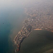
 South Mumbai precinct highlighted in yellow | |
18°57′00″N 72°47′42″E / 18.95°N 72.795°E / 18.95; 72.795 | |
| Country |  India India |
| State |  Maharashtra Maharashtra |
| District |  Mumbai City Mumbai City |
| City | Mumbai |
| Wards | A, B, C, D, E, FS, FN, GS, GN |
| Government | |
| • Body | BMC |
| Area | |
| • Total | 67.7 km2 (26.1 sq mi) |
| Population (2011) | |
| • Total | 3,145,966 |
| • Density | 46,000/km2 (120,000/sq mi) |
| Demonym(s) | Mumbaikar, Soboite |
| Time zone | UTC+5:30 (IST) |
| Year | Pop. | ±% |
|---|---|---|
| 1971 | 3,070,380 | — |
| 1981 | 3,285,040 | +7.0% |
| 1991 | 3,174,910 | −3.4% |
| 2001 | 3,326,840 | +4.8% |
| 2011 (est) | 3,145,966 | −5.4% |
| Data is based on Government of India Census. Source: MMRDA[1] | ||

South Mumbai, colloquially SoBo from South Bombay in Indian English,[2][3] administratively the Mumbai City District, is the city centre and the southernmost precinct of Greater Bombay. It extends from Colaba to Mahim and Sion neighbourhoods, and comprises the city's main business localities, making it the wealthiest urban precinct in India. Property prices in South Mumbai are by far the highest in India and among the highest in the world.[citation needed]
Taj Mahal Hotel, Gateway of India, Victoria Terminus, Ballard Estate, and the Bombay Harbour are some of the most iconic landmarks of South Bombay. Billionaire Mukesh Ambani's $1.5 billion home Antilia is located here and is now a part of the iconic skyline. Most residents of South Mumbai belong to old money business, law, trade and fashion families. Geographically, South Mumbai lies at the southern most extent of Salsette Island. Most city residents use the term to refer to the stretch extending from Colaba to Mahim and Sion as South Mumbai. The area is delimited on the east by Mumbai harbour and on the west by the Arabian Sea.
South Mumbai is also home to many educational institutions; namely Cathedral and John Connon School, St. Anne's High School, Fort, JB Petit, Campion, Bombay International School, St. Mary's School, Mumbai, etc; exclusive sports clubs: CCI, The Willingdon Sports Club, as well as the Bombay Gymkhana; and hospitals such as Breach Candy Hospital, Bombay Hospital, Jaslok Hospital, and Hurkisondas Hospital.
Significance
South Mumbai hosts the Reserve Bank of India, Bombay Stock Exchange and one of the oldest YMCA buildings. Its primary business districts are the Fort, Nariman Point, Ballard Estate and more recently Lower Parel, Mumbai Central. Many leading Indian and multi-national companies are headquartered here. Chhatrapati Shivaji Maharaj Terminus (CSMT) and Churchgate serve as headquarters and starting point for country's Central Railway and Western Railway lines respectively.
The headquarters of the Brihanmumbai Municipal Corporation, the governing civic body of Greater Mumbai is located in South Mumbai. The Bombay High Court is also in South Mumbai.
The terrorist attacks of 2008 included many prominent South Mumbai locations including Taj Mahal Palace Hotel in Colaba, Leopold Cafe and Chhatrapati Shivaji Maharaj Terminus.[4]
The area houses a significant proportion of prime upmarket residential neighbourhoods of Mumbai including: Pedder Road, Nepean Sea Road, Kemps Corner, Altamount Road, Carmichael Road, Breach Candy and Walkeshwar Road, forming a sort of golden quadrilateral and includes some of the most expensive residential areas in the world, such as the Hanging Gardens, Kemps Corner, Cuffe Parade and Malabar Hill.
South Mumbai is home to two UNESCO World Heritage Sites: Chhatrapati Shivaji Maharaj Terminus and the city's distinctive ensemble of Victorian and Art Deco buildings. South Mumbai boasts a large number of Art Deco buildings, second only to Miami.[5] South Mumbai's architecture also comprises historical monuments from the colonial era which attract tourists throughout the year.
South Mumbai has many educational institutions such as Jamnalal Bajaj Institute of Management Studies, St. Xavier's College, Government Law College, Jai Hind College, Wilson College, Grant Medical College, Sydenham Institute of Management Studies, Research and Entrepreneurship Education, among others.
Many distinctive sporting clubs have been an integral part of South Mumbai landscape like the Willingdon Sports Club, the Turf Club at Mahalaxmi Racecourse, the Bombay Gymkhana, the Breach Candy Club, the N.S.C.I., and the Malabar Hill Club (Formerly W.I.A.A. Club). The Cricket Club of India (CCI) and Mumbai Cricket Association (MCA) are located at Mumbai's two cricket stadiums, namely Brabourne Stadium and Wankhede Stadium respectively.
Although land reclamation has allowed the southernmost tip of the district to double in size since the 1970s, the business districts face an acute shortage of real estate. As a result, the real-estate prices are among the top ten worldwide. As a ratio to average per capita income, real-estate prices in the business districts remain the most expensive in the world.[6]
South Mumbai is also home to such sporting grounds as Brabourne Stadium, Wankhede Stadium, Shivaji Park, Azad Maidan, Oval Maidan, and Cooperage Ground.
Mumbai's most popular beach, Girgaon Chowpatty is located at the beginning of a 3.6 km esplanade known as the Marine Drive which is a popular hangout spot among the citizens. Another popular esplanade in South Mumbai is the Worli Seaface.
South Mumbai has popular art galleries and museums like Chhatrapati Shivaji Maharaj Vastu Sangrahalaya, Jehangir Art Gallery, Nehru Centre Art Gallery. Sobo Films, an independent film producer, has been named after the area but is itself based in Andheri in the west.[7]
South Mumbai has become less congested with the creation of the Bandra Worli Sea Link. Auto rickshaws are strictly banned here. This facilitates quicker transport between people residing in the suburbs and the corporate offices in South Mumbai. Traffic is a major concern in most parts.
Division
The city of Mumbai lies on Salsette Island. Administratively it has two official divisions: Mumbai City district and Mumbai Suburban district. Mumbai City district consists of the Southern part of Salsette Island - the area is called South Mumbai. Mumbai Suburban district consists the Western, Eastern, Central and Northern parts of the city. The northernmost portion of the island - outside Mumbai city limits - lies in Thane district.
Old Bombay

Old Bombay was used to refer to the area which was formed by the merging of the seven original islands of Mumbai, India. The term was used from the 19th century until the 1980s and is now considered archaic, however still widely used.
See also
- Salsette Island
- Western Suburbs
- Eastern Suburbs
- Pali Hill
- Soho, London
- SoHo, Manhattan
Notes
- "Population and Employment profile of Mumbai Metropolitan Region" (PDF). Mumbai Metropolitan Region Development Authority (MMRDA). Archived from the original (PDF) on 13 June 2010. Retrieved 4 June 2010.
References
- ^ Population and Employment profile of Mumbai Metropolitan Region, p. 7
- ^ Eyewitness, D. K. (3 October 2019). DK Eyewitness Top 10 Mumbai. Dorling Kindersley Limited. ISBN 978-0-241-43046-0.
- ^ "Malavika's Mumbaistan: Mumbai's North-South Divide". Hindustan Times. 2 July 2021. Retrieved 29 November 2021.
- ^ "Mumbai Terrorist Attacks Of 2008 | Events, Death Toll, & Facts | Britannica". www.britannica.com. Retrieved 16 November 2022.
- ^ Chandrashekhar, Vaishnavi (21 October 2019). "Discovering Mumbai's Art Deco Treasures". The New York Times. ISSN 0362-4331. Retrieved 16 November 2022.
- ^ Sheng, Ellen. "The Five Most Expensive Cities In The World". Forbes. Retrieved 16 November 2022.
- ^ Sobo Films, sobofilms.com. Accessed 1 March 2024.
External links
Wikivoyage has a travel guide for South Mumbai.
- Altamont Road – Voted 10th Richest
Wikimedia Commons has media related to South Mumbai.
- v
- t
- e
Mumbai topics
- Powai Lake
- Vihar Lake
- Tulsi Lake
- Thane Creek
- Mahim Bay
- Back Bay
- Mithi River
- Ulhas River
- Gilbert Hill
- Malabar Hill
- Salsette Island
- Mumbai Harbour
- Middle Ground
- Climate
- Beaches
- Eastern Suburbs
- Western Suburbs
- South Mumbai
- Neighbourhoods
- Architecture of Mumbai
- Gateway of India
- Chhatrapati Shivaji Terminus
- Naval Dockyard
- Bombay Stock Exchange
- Hutatma Chowk
- General Post Office
- Shreepati Arcade
- Siddhivinayak Temple
- Regal Cinema
- Mount Mary's Church
- Haji Ali Dargah
- Flora Fountain
- David Sassoon Library
- Mumba Devi Temple
- Mahalaxmi Temple
- Chhatrapati Shivaji Maharaj Vastu Sangrahalaya (Prince of Wales Museum)
- National Gallery of Modern Art
- The Asiatic Society of Mumbai
- Jehangir Art Gallery
- Gowalia Tank
- Shri Swaminarayan Mandir
- Mahim Church
- Usha Kiran Building
- Jinnah Mansion
- Brihanmumbai Electric Supply and Transport (BEST)
- Mumbai Suburban Railway
- Central Line
- Harbour Line
- Nerul–Uran Line
- Trans-Harbour Line
- Western Line
- Central Railway
- Western Railway
- Chhatrapati Shivaji Maharaj International Airport
- Bandra Terminus and suburban station
- Chhatrapati Shivaji Terminus
- Dadar railway station and suburban station
- Lokmanya Tilak Terminus
- Mumbai Central railway station
- Juhu Aerodrome
- Auto rickshaw
- Metro
- Line 1
- Line 2
- Line 3
- Line 4
- Line 5
- Line 6
- Line 7
- Line 8
- Line 9
- Line 10
- Line 11
- Line 12
- Line 13
- Monorail
- Skywalk
- Western railway elevated corridor
- Water transport
- Mumbai Bus Rapid Transit System
- Mumbai Urban Transport Project
- Airoli Bridge
- Altamount Road
- Bandra–Worli Sea Link
- Carmichael Road
- Colaba Causeway
- Coastal Road (under construction)
- Currey Road Bridge
- Dadabhai Naoroji Road
- Eastern Express Highway
- Eastern Freeway
- Fashion Street
- Hughes Road
- Jeejabai Bhosle Marg
- JVLR
- Kalwa Bridge
- Linking Road
- Lady Jamshetjee Road
- LBS Marg
- Lamington Road
- Mahim Causeway
- Marine Drive
- MTHL
- Nepean Sea Road
- P D'Mello Road
- Pedder Road
- Princess Street
- SCLR
- SV Road
- Sahar Elevated Access Road
- Sion Panvel Highway
- Vashi Bridge
- Versova–Bandra Sea Link
- Veera Desai Road
- Western Express Highway
and research
 Category
 Commons

| |
|---|---|
| Pre-colonial | |
| Colonial | |
| Beaches | |
| Places of worship | |
| Cultural |
|
| Boulevards | |
| Districts | 
|
| Shopping | |
| Buildings | |
| Parks, zoos and stadia | |
| Museums | |
| Forts | |
| Restaurants & Bars | |


18°58′N 72°49′E / 18.96°N 72.82°E / 18.96; 72.82


