South William Street, Dublin
Street in Dublin, Ireland
53°20′30″N 6°15′46″W / 53.341697°N 6.262876°W / 53.341697; -6.262876
William Street South, commonly known as South William Street,[1][2][3] (Irish: Plás Mhic Liam Theas) is a street located on Dublin's Southside.
Location
It runs from the junction with Exchequer Street, Wicklow Street, and St. Andrew's Street on its northeastern end to the junction of Johnson Place and Stephen Street on its southwestern end.
History
The street was laid out in 1676 by William Williams and was part of Dublin's 17th-century expansion beyond its medieval walls. The street has one of the largest and most complete groups of 18th century merchants' houses in the city.[4][5] However, M'Cready claims the street is named after King William III.[6]
In 2012, the street was rebranded as being the centre of Dublin's "Creative Quarter", an area noted for its "independent design stores, fashion outlets and cafes".[7] The UK's Academy of Urbanism has noted that the street has transformed "from the bustling heart of the rag trade to a well-known spot for retail entrepreneurs, start-ups and those in search of a good night out".[8]
Powerscourt House
The street is dominated by Powerscourt House, the former Dublin townhouse of Viscount Powerscourt. It was constructed in the 18th century for Richard Wingfield, 3rd Viscount Powerscourt, a member of the Irish House of Lords.[9] The townhouse was the Wingfield family's urban residence when they were visiting from the Powerscourt Estate in Enniskerry, County Wicklow.
Designed by Robert Mack, it dates from between 1771 and 1774. The court at the rear of the building was created with the addition of three brown-brick office buildings from 1809 to 1811. The townhouse was purchased and redeveloped as a shopping centre between 1978 and 1981 and is now known as the Powerscourt Townhouse Centre.[10]
Gallery
-
 Metro Cafe, South William Street
 -
 Pink restaurant, South William Street
 -
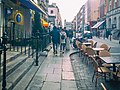 South William Street, looking southwest


See also
References
- ^ "Cafe society gives cosmopolitan image to Dublin's fastest changing street". The Irish Times. Retrieved 13 February 2022.
- ^ "People should gift cash they saved to ailing restaurants". independent. Retrieved 13 February 2022.
- ^ "The Pepper Pot Review - Dublin Ireland - Restaurant | Fodor's Travel". www.fodors.com. Retrieved 13 February 2022.
- ^ "Knocking on doors to save valuable 18th century street". The Irish Times. Retrieved 13 February 2022.
- ^ Clerkin, Paul (2001). Dublin street names. Dublin: Gill & Macmillan. pp. 190–191. ISBN 0-7171-3204-8. OCLC 48467800.
- ^ M'Cready, C. T. (1987). Dublin street names dated and explained. Blackrock, Co. Dublin: Carraig. p. 144. ISBN 1-85068-005-1. OCLC 263974843.
- ^ Freeman, Michael. "Dublin launches new 'Creative Quarter' for city centre". TheJournal.ie. Retrieved 13 February 2022.
- ^ Admin. "South William Street | The Academy of Urbanism". Retrieved 13 February 2022.
- ^ "Powerscourt Townhouse Centre, 59 South William Street, Dublin 2, DUBLIN". Buildings of Ireland. Retrieved 13 February 2022.
- ^ Casey, Christine (2005). Dublin: the city within the Grand and Royal Canals and the Circular Road with the Phoenix Park. New Haven, Conn.; London: Yale University Press. ISBN 978-0-300-10923-8. OCLC 61702208.
- v
- t
- e
(Northside)
- Abbey Street
- Amiens Street
- Arbour Hill
- Bachelors Walk
- Benburb Street
- Beresford Place
- Blackhall Place
- Bloom Lane
- Buckingham Street
- Capel Street
- Cathal Brugha Street
- Cathedral Street
- Clonliffe Road
- Dominick Street
- Dorset Street
- East Wall Road
- Eccles Street
- Eden Quay
- Foley Street
- Gardiner Street
- Great Denmark Street
- Henrietta Street
- Henry Street
- Home Farm Road
- Jervis Street
- Marino Crescent
- Marlborough Street
- Mary Street
- Moore Street
- North Circular Road
- North Earl Street
- North Great George's Street
- North Strand Road
- O'Connell Street
- Parnell Street
- Queen Street
- Seán McDermott Street
- Sheriff Street
- Store Street
- Summerhill Parade
- Talbot Street
(Southside)
- Ailesbury Road
- Anglesea Road
- Aungier Street
- Baggot Street
- Bow Lane West
- Boyne Street
- Bride Street
- Britain Quay
- Bull Alley Street
- Camden Street
- Christchurch Place
- Clanbrassil Street
- Clare Street
- Clyde Road
- College Green
- College Street
- The Coombe
- Coppinger Row
- Cork Street
- Crampton Court
- Cuffe Street
- Dame Lane
- Dame Street
- Dawson Street
- D'Olier Street
- Earlsfort Terrace
- Ely Place
- Eustace Street
- Fenian Street
- Fishamble Street
- Fleet Street
- Fownes Street
- Fumbally Lane
- Georges Quay
- Grafton Street
- Harcourt Street
- Harcourt Terrace
- Hawkins Street
- Herbert Park
- Herbert Road
- Heytesbury Street
- High Street
- Hume Street
- James's Street
- Kildare Street
- Lansdowne Road
- Leeson Street
- Lincoln Place
- Marrowbone Lane
- Merrion Road
- Merrion Street
- Misery Hill
- Molesworth Street
- Morehampton Road
- Mount Street Lower
- Nassau Street
- Northumberland Road
- Newbridge Avenue
- New Bride Street
- Park Avenue
- Parliament Street
- Patrick Street
- Pearse Street
- Raglan Road
- Sandymount Avenue
- Shelbourne Road
- Shrewsbury Road
- Sir John Rogerson's Quay
- South Circular Road
- South Great George's Street
- South William Street
- St Andrew's Street
- Steeven's Lane
- Sydney Parade Avenue
- Tara Street
- Thomas Street
- Tritonville Road
- Werburgh Street
- Westland Row
- Westmoreland Street
- Wexford Street
- Wicklow Street
- Winetavern Street
- Wood Quay
- York Street


