Spiess Rocks
Submerged rock formation of Bouvet Island
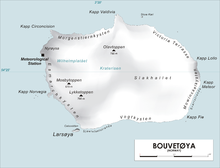
Spiess Rocks (54°25′S 3°29′E / 54.417°S 3.483°E / -54.417; 3.483) is a group of submerged rocks which extend up to 0.4 nautical miles (0.7 km) northeast of Cape Lollo on the island of Bouvetøya. First charted in December 1927 by a Norwegian expedition under Captain Harald Horntvedt. Named by the Norwegians for Captain Fritz A. Spiess, leader of the German expedition which visited Bouvetoya on board the Meteor in 1926. [1] [2]
References
Other sources
- Simpson-Housley, Paul (2002) Antarctica: Exploration, Perception and Metaphor (Routledge) ISBN 9781134891214
![]() This article incorporates public domain material from "Spiess Rocks". Geographic Names Information System. United States Geological Survey.
This article incorporates public domain material from "Spiess Rocks". Geographic Names Information System. United States Geological Survey. ![]()
- v
- t
- e


