State Road Covered Bridge
Bridge in Ohio, United States
41°53′11″N 80°37′14″W / 41.88639°N 80.62056°W / 41.88639; -80.62056
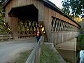
State Road Bridge is a covered bridge spanning Conneaut Creek in Monroe Township, Ashtabula County, Ohio, United States. The bridge, one of currently 17 drivable bridges in the county, is a single span Town truss design. Constructed of 97,000 feet (30,000 m) of southern pine and oak, it features a 4-foot-tall (1.2 m) window which extends the length of the bridge. The dedication of the bridge in 1983 was the forerunner of the Ashtabula County Covered Bridge Festival.[1] The bridge’s WGCB number is 35-04-58,[2] and it is located approximately 3.9 miles (6.3 km) east-southeast of North Kingsville.
State Road Bridge is not to be confused with a covered bridge on another State Road in the county, Smolen-Gulf Bridge.
History
- 1983 – Bridge constructed.[1]
The current structure replaced the original covered bridge on this site; that was built in 1831, by Ira Benton, and David Niles, for a cost of $100 and stood until 1898.
Dimensions
- Span: 140 feet (42.7 m)
- Length: 157 feet (47.9 m)
- Width: 17 feet 6 inches (5.33 m)
- Height: 14 feet 6 inches (4.42 m)
Gallery
-
 Closer view from the south
 -
 View from the southeast
 -

-


See also
References
- ^ a b "Ashtabula County Ohio Covered Bridge Festival". Archived from the original on 2006-12-07. Retrieved 2006-11-20. Ashtabula County Ohio Covered Bridge Festival
- ^ http://www.dalejtravis.com/bridge/ohio/htm/3500458.htm Ohio Covered Bridges List, 35-04-58
External links
- Ohio Covered Bridges List
- Ohio Covered Bridge Homepage
- The Covered Bridge Numbering System
- Ohio Historic Bridge Association
- State Road Covered Bridge from Ohio Covered Bridges, Historic Bridges
- "State Road Bridge". Geographic Names Information System. United States Geological Survey. Retrieved 2012-12-30.
| Authority control databases: Geographic |
|
|---|


