Flugplatz Straubing-Wallmühle | |||||||||||
|---|---|---|---|---|---|---|---|---|---|---|---|
 | |||||||||||
| Summary | |||||||||||
| Airport type | Public | ||||||||||
| Location | Straubing, Germany | ||||||||||
| Elevation AMSL | 1,054 ft / 321 m | ||||||||||
| Coordinates | 48°54′05″N 012°31′03″E / 48.90139°N 12.51750°E | ||||||||||
| Website | airport-straubing.com | ||||||||||
| Map | |||||||||||
 Flugplatz Straubing-Wallmühle | |||||||||||
 | |||||||||||
| Runways | |||||||||||
| |||||||||||
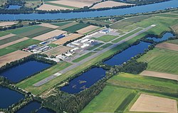
Straubing Wallmühle Airport (IATA: RBM, ICAO: EDMS) is a minor German regional airport, located about 3 miles north-northwest of Straubing in Bavaria. It is used for general aviation.
History
[edit]Today's Straubing Airfield was founded at the beginning of the 1960s by several flight enthusiasts from Straubing. At first, only gliding operations with winch towing took place. In 1972, Straubing-Wallmühle Airfield was founded as a limited liability company by the two shareholders, the city of Straubing and the district of Straubing-Bogen. Since that time, the airport has been a public transport company (Verkehrslandeplatz) with a daily duty to operate at binding opening times.
Airlines and destinations
[edit]As of April 2016, there are no scheduled services to or from Straubing. Briefly, during early 2016, Danish charter airline Flexflight offered services between Straubing and Salzburg Airport.[2] Flights were later moved from Straubing to Augsburg Airport.[3]
References
[edit]- ^ "AIP VFR online". dfs.de. DFS Deutsche Flugsicherung GmbH. Retrieved 2023-02-21.
- ^ "Neu: Straubing-Salzburg ab 278 Euro - Austrian Aviation Net". www.austrianaviation.net. Archived from the original on 2016-03-02.
- ^ "Flexflight - Flexflight". www.flexflight.dk. Archived from the original on 2012-02-22.
External links
[edit]![]() Media related to Straubing Wallmühle Airport at Wikimedia Commons
Media related to Straubing Wallmühle Airport at Wikimedia Commons
- Airport official website
- Airport information for EDMS at Great Circle Mapper.
- Important note: Advanced Landing Ground ALG R-68 Straubing and Mansfield Kaserne is not today's Straubing Wallmühle Airport. ALG R-68 Straubing is today's Gäuboden barracks of the German Armed Forces Bundeswehr. See also Bavarian National Map BayernAtlas: Gäubodenkaserne south-southwest of Straubing (Lower Bavaria, Germany); See also Bavarian National Map Topogr. Karte 1:25.000, Year of issue 1955 with Mansfield barracks and airfield near Mitterharthausen.