Subprefecture of Lapa
Subprefecture in Southeast, Brazil
Subprefecture of Lapa | |
|---|---|
Subprefecture | |
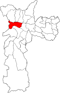 Location of the Subprefecture of Lapa in São Paulo | |
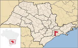 Location of municipality of São Paulo within the State of São Paulo | |
| Country |  Brazil Brazil |
| Region | Southeast |
| State |  São Paulo São Paulo |
| Municipality |  São Paulo São Paulo |
| Administrative Zone | West |
| Districts | Lapa, Barra Funda, Perdizes, Vila Leopoldina, Jaguaré, Jaguara |
| Government | |
| • Type | Subprefecture |
| • Subprefect | Carlos Eduardo Batista |
| Area | |
| • Total | 40.57 km2 (15.66 sq mi) |
| Population (2008) | |
| • Total | 255,185 |
| Website | Subprefeitura Lapa (Portuguese) |
The Subprefecture of Lapa is one of 32 subprefectures of the city of São Paulo, Brazil. It comprises six districts: Lapa, Barra Funda, Perdizes, Vila Leopoldina, Jaguaré, and Jaguara.[1]
In the north area of Lapa, which comprises the bairros of Barra Funda, Água Branca and the "Low Lapa" (Lapa de baixo) most of the people are descendants of proletarian families who once worked in the two main railways of the city: São Paulo Railway and the Sorocabana. Today, both of these railways station have become local urban train stations.
The southern area of the subprefecture, which includes the "High Lapa" (Alto da Lapa) and the bairros of Perdizes, Sumaré and Pompéia, is a high-class area and has many historic buildings, and has many descendant of the English engineers who built the railways. Also the main campus of the Pontifical Catholic University of São Paulo (PUC-SP) is located in this place, in the district of Perdizes, as well as Allianz Arena, home of the football team Palmeiras.
References
- ^ Official subprefecture website (Portuguese)
- v
- t
- e

- Aricanduva
- Butantã
- Campo Limpo
- Capela do Socorro
- Casa Verde
- Cidade Ademar
- Cidade Tiradentes
- Ermelino Matarazzo
- Freguesia-Brasilândia
- Guaianases
- Ipiranga
- Itaim Paulista
- Itaquera
- Jabaquara
- Jaçanã-Tremembé
- Lapa
- M'Boi Mirim
- Mooca
- Parelheiros
- Penha
- Perus
- Pinheiros
- Pirituba-Jaraguá
- Santana-Tucuruvi
- Santo Amaro
- São Mateus
- São Miguel Paulista
- Sé
- Sapopemba
- Vila Maria-Vila Guilherme
- Vila Mariana
- Vila Prudente
- Água Rasa
- Alto de Pinheiros
- Anhanguera
- Aricanduva
- Artur Alvim
- Barra Funda
- Bela Vista
- Belém
- Bom Retiro
- Brasilândia
- Brás
- Butantã
- Cachoeirinha
- Cambuci
- Campo Belo
- Campo Grande
- Campo Limpo
- Cangaíba
- Capão Redondo
- Carrão
- Casa Verde
- Cidade Ademar
- Cidade Dutra
- Cidade Líder
- Cidade Tiradentes
- Consolação
- Cursino
- Ermelino Matarazzo
- Freguesia do Ó
- Grajaú
- Guaianases
- Iguatemi
- Ipiranga
- Itaim Bibi
- Itaim Paulista
- Itaquera
- Jabaquara
- Jaçanã
- Jaguara
- Jaguaré
- Jaraguá
- Jardim Helena
- Jardim Paulista
- Jardim São Luís
- Jardim Ângela
- José Bonifácio
- Lajeado
- Lapa
- Liberdade
- Limão
- Mandaqui
- Marsilac
- Moema
- Mooca
- Morumbi
- Parelheiros
- Pari
- Parque do Carmo
- Pedreira
- Penha
- Perdizes
- Perus
- Pinheiros
- Pirituba
- Ponte Rasa
- Raposo Tavares
- República
- Rio Pequeno
- Sacomã
- Santa Cecília
- Santana
- Santo Amaro
- São Domingos
- São Lucas
- São Mateus
- São Miguel Paulista
- São Rafael
- Saúde
- Sapopemba
- Sé
- Socorro
- Tatuapé
- Tremembé
- Tucuruvi
- Vila Andrade
- Vila Curuçá
- Vila Formosa
- Vila Guilherme
- Vila Jacuí
- Vila Leopoldina
- Vila Maria
- Vila Mariana
- Vila Matilde
- Vila Medeiros
- Vila Prudente
- Vila Sônia
23°31′11″S 46°42′15″W / 23.51972°S 46.70417°W / -23.51972; -46.70417
 | This geographical article relating to the state of São Paulo is a stub. You can help Wikipedia by expanding it. |
- v
- t
- e


