Světlík
Municipality in South Bohemian, Czech Republic
Flag
Coat of arms
 Czech Republic
 (2023-01-01)[1]
382 16
Světlík (German: Kirchschlag) is a municipality and village in Český Krumlov District in the South Bohemian Region of the Czech Republic. It has about 200 inhabitants.
Etymology
The name is derived from the adjective světlý ('bright') and referred to a bright forest.[2]
Geography
Světlík is located about 11 kilometres (7 mi) southwest of Český Krumlov and 32 km (20 mi) southwest of České Budějovice. It lies in the Bohemian Forest Foothills. The highest point is a hill at 855 m (2,805 ft) above sea level. The stream Strážný potok originates here and flows across the municipality.
History
The first written mention of Světlík is from 1258. From 1624 until the establishment of an independent municipality in 1850, it was part of the Český Krumlov estate.[3]
Demographics
|
|
| ||||||||||||||||||||||||||||||||||||||||||||||||||||||
| Source: Censuses[4][5] | ||||||||||||||||||||||||||||||||||||||||||||||||||||||||
Transport
There are no railways or major roads passing through the municipality.
Sights
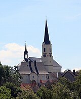
The main landmark of Světlík is the Church of Saint James the Great. It was built in the mid-13th century, its current appearance is a result of pseudo-Romanesque reconstruction in 1872–1874. The building of the rectory dates from the 18th century.[6]
The ruins of the Pasovary Fortress are located in the northeastern part of the municipality. The fortress was founded in the 13th century. Only the torso of the masonry and the tower from the 14th century have survived.[7]
References
- ^ "Population of Municipalities – 1 January 2023". Czech Statistical Office. 2023-05-23.
- ^ Profous, Antonín (1957). Místní jména v Čechách IV: S–Ž (in Czech). pp. 249–250.
- ^ "O obci" (in Czech). Obec Světlík. Retrieved 2023-01-03.
- ^ "Historický lexikon obcí České republiky 1869–2011 – Okres Český Krumlov" (in Czech). Czech Statistical Office. 2015-12-21. pp. 29–30.
- ^ "Population Census 2021: Population by sex". Public Database. Czech Statistical Office. 2021-03-27.
- ^ "Kostel sv. Jakuba Většího s farou a výklenková kaple sv. Jana Nepomuckého" (in Czech). National Heritage Institute. Retrieved 2023-01-03.
- ^ "Zřícenina tvrze Pasovary" (in Czech). National Heritage Institute. Retrieved 2023-01-03.
External links
Wikimedia Commons has media related to Světlík.
- Official website
- v
- t
- e
Towns, market towns, villages and military training area of Český Krumlov District
- Benešov nad Černou
- Besednice
- Bohdalovice
- Brloh
- Bujanov
- Černá v Pošumaví
- Český Krumlov
- Chlumec
- Chvalšiny
- Dolní Dvořiště
- Dolní Třebonín
- Frymburk
- Holubov
- Horní Dvořiště
- Horní Planá
- Hořice na Šumavě
- Kájov
- Kaplice
- Křemže
- Lipno nad Vltavou
- Loučovice
- Malonty
- Malšín
- Mirkovice
- Mojné
- Netřebice
- Nová Ves
- Omlenice
- Pohorská Ves
- Polná na Šumavě
- Přední Výtoň
- Přídolí
- Přísečná
- Rožmberk nad Vltavou
- Rožmitál na Šumavě
- Soběnov
- Srnín
- Střítež
- Světlík
- Velešín
- Větřní
- Věžovatá Pláně
- Vyšší Brod
- Zlatá Koruna
- Zubčice
- Zvíkov
- Boletice Military Training Area
| Authority control databases: National |
|
|---|


