Takayama, Gunma
Village in Kantō, Japan
Takayama  Flag  Seal | |
|---|---|
 Location of Takayama in Gunma Prefecture | |
| 36°37′4.7″N 138°56′36.9″E / 36.617972°N 138.943583°E / 36.617972; 138.943583 | |
| Country | Japan |
| Region | Kantō |
| Prefecture | Gunma |
| District | Agatsuma |
| Area | |
| • Total | 64.18 km2 (24.78 sq mi) |
| Population (September 2020) | |
| • Total | 6,889 |
| • Density | 110/km2 (280/sq mi) |
| Time zone | UTC+9 (Japan Standard Time) |
| - Tree | Oak |
| - Flower | Japanese Gentian |
| - Bird | Copper pheasant |
| Phone number | 0279-63-2111 |
| Address | 2856-1 Nakayama, Takayama-mura, Agatsuma-gun, Gunma-ken 377-0702 |
| Website | Official website |

Takayama (高山村, Takayama-mura) is a village located in Gunma Prefecture, Japan. As of 1 September 2020[update], the village had an estimated population of 6,889 in 2449 households,[1] and a population density of 110 persons per km2. The total area of the village is 64.18 square kilometres (24.78 sq mi).
Geography
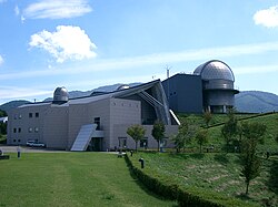
Located at the easternmost point of Agatsuma District, Takayama is surrounded by mountains at all cardinal directions. The Gunma Telescope is located on Mount Komochi in the south.
- Mountains: Mount Onoko (1208m), Junigadake (1200.9m), Mount Komochi (1296m)
- Rivers: Agatsuma River
Surrounding municipalities
Climate
Takayama has a Humid continental climate (Köppen Dfb) characterized by warm summers and cold winters with heavy snowfall. The average annual temperature in Takayama is 6.7 °C. The average annual rainfall is 1548 mm with September as the wettest month. The temperatures are highest on average in August, at around 21.7 °C, and lowest in January, at around -5.7 °C.[2]
Demographics
Per Japanese census data,[3] the population of Takayama has remained relatively steady over the past century.
| Year | Pop. | ±% |
|---|---|---|
| 1920 | 3,286 | — |
| 1930 | 3,688 | +12.2% |
| 1940 | 4,025 | +9.1% |
| 1950 | 4,965 | +23.4% |
| 1960 | 4,813 | −3.1% |
| 1970 | 4,161 | −13.5% |
| 1980 | 4,788 | +15.1% |
| 1990 | 4,087 | −14.6% |
| 2000 | 4,348 | +6.4% |
| 2010 | 3,911 | −10.1% |
| 2020 | 3,511 | −10.2% |
History
During the Edo period, the area around Takayama was part of the hatamoto-administered territory within Kōzuke Province. With the creation of the modern municipalities system after the Meiji Restoration on April 1, 1889, the village of Takayama was created within Agatsuma District of Gunma Prefecture.
Government
Takayama has a mayor-council form of government with a directly elected mayor and a unicameral village council of 10 members. Takayama, collectively with the other municipalities in Agatsuma District, contributes two members to the Gunma Prefectural Assembly. In terms of national politics, the village is part of Gunma 5th district of the lower house of the Diet of Japan.
Economy
The economy of Takayama is primarily agricultural.
Education
Takayama has one public elementary school and one public middle school operated by the village government. The village does not have a high school.
Transportation
Takayama is served by a rail line from Nagoya.
It is also home to one of 10 musical roads located in Gunma prefecture alone; the song played is "When You Wish Upon a Star."
Local attractions
- Marble Village Lockheart Castle
- Gunma Prefectural Astronomical Observatory
References
External links
Wikimedia Commons has media related to Takayama, Gunma.
- Official Website (in Japanese)


Authority control databases | |
|---|---|
| International |
|
| National |
|
| Geographic |
|


