The Avenues, Kingston upon Hull
Area of Kingston upon Hull, East Riding of Yorkshire, England
53°45′31″N 0°21′57″W / 53.758643°N 0.365813°W / 53.758643; -0.365813

The Avenues is an area of high status Victorian housing located in the north-west of Kingston upon Hull, England. It is formed by four main tree-lined straight avenues running west off the north-north-east/south-south-west running Princes Avenue.
The Avenues area, originally built as middle class housing in the late 19th century, has remained a popular residential area; its popularity with left wing intellectuals and academics, and varied leafy cosmopolitan ambience has caused it to be stereotyped as Hull's 'Muesli Belt'.[1] To the adjoining south of the Avenues is an area of roughly contemporary Victorian terraces, with streets named after the seats of nobles; it is sometimes referred to as the Dukeries.
Whilst primarily housing, the area hosted the Industrial School for Girls from 1888 to 1919 on Park Avenue, the building afterwards used for other educational purposes, now known as the Avenues Centre. Marlborough Avenue is the location of Froebel House Preparatory School.[2]
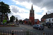
Princes Avenue was a popular urban shopping street during the 20th century. In the 21st century it has remained commercial with increasing numbers of specialist shops, restaurants and other food outlets.[3]
History

The Avenues were constructed on a green field site known as Newland Tofts from the latter part of the 19th century onwards.[note 1] The boundaries were formed by: Newland Tofts Lane (Princes Avenue), and the parallel Derringham Dike to the east; Setting Dyke to the north; Spring Bank and Spring and Derringham Dikes to the south; and to the west a field boundary between Newland Tofts and Ewe lands and Chanter Lands which eventually became Chanterlands Avenue. To the south the area was limited by the new (1847) General Cemetery built on the northern side of Derringham Bank (Spring Bank West).[4][5]
The estate was formally opened in 1875 by the developer David Parkinson Garbutt;[note 2] it was built on the outskirts of Hull with recently opened facilities nearby: Pearson Park (opened 1860) on the east side of Princes Avenue, and Botanic Gardens railway station (up to 1881 known as Cemetery Gates) at the southern end of Princes Avenue.[3] The site was laid out on a generous scale for the middle and prosperous classes; the largest street; Westbourne Avenue was 59 feet (18 m) wide.[3]
Early developments included houses by George Gilbert Scott the Younger, built 1877–79,[3] which are now listed buildings.[7][note 3] The area was primarily residential, in 1888 the Hull School board opened the 'Industrial School for Girls', a residential corrective institution on Park Avenue.[note 4] A small preparatory school Froebel House was established in 1906 on Marlborough Avenue;[note 5] in the same year St Cuthberts church was constructed on Marlborough Avenue.[note 6][13]
In 1900 electric trams began to travel on Princes Avenue on a route that linked to the city centre by Spring Bank.[14]
The area to the south of the Avenues, and north of Hull General Cemetery was developed around 1900; terraces of un-gardened houses were built on east-west rows of streets named after ducal seats: Welbeck Street (Welbeck Abbey), Newstead Street (Newstead Abbey), Thoresby Street (Thoresby Hall), Belvoir Street (Belvoir Castle) and Blenheim Street (Blenheim Palace);[15] as a consequence the area became known as the "Dukeries".[16] (see also The Dukeries, Nottinghamshire).
By 1910, the entire estate was mostly developed with few vacant plots remaining, the land to the north (Newland Avenue), and to the south (the Dukeries) had also been developed as housing,[17] by the 1920s the land to the west had been urbanised with the construction of Chanterlands Avenue, and associated terraced housing.[18][note 7]
Both sides of Princes Avenue were developed by 1910,[17] with notable structures including the Elim Pentecostal church (1897–99), which until 1982 was a Congregationalist church known as Fish Street Memorial Church,[20][21][22] and a Methodist church (1905, architect Alfred Gelder);[23] by 1910 Princes Avenue was fully developed as a shopping street, with multiple competing premises in all the major realms of commerce – grocers, fishmongers, butchers, hardware, confectioners etc.[24]
Much of the Avenues area was developed piecemeal in small plots; many of the British housing styles used in the late 19th and early 20th century are found in the area, including revived Queen Anne style (in the Gilbert Scott Jr. houses), mock Tudor, arts and crafts, and a variety of vernacular styles.[3]
As part of the original layout of the development Westbourne, Marlborough and Victoria Avenue had cast iron decorative fountains in the centre of the roads, with two more on Princes Avenue. All were of similar circular tiered design. The fountains on Princes Avenue were removed in 1926 due to increased traffic.[25] The remaining fountains on Westbourne and Park Avenue are now listed structures.[26][note 8][14][28] A replica of the Victoria Avenue Fountain, removed after an accident in the 1920s, was unvelied on 8 July 2023.[29]
The tram system on Princes Avenue was replaced with a trolleybus service in 1937;[14] the trolley buses were replaced in turn by motor buses in the 1960s.[30] The Botanic Gardens railway station closed in the 1960s with the closure of the Victoria Dock Branch Line.[31]
Small scale infill development created Parkside Close (1960s) on undeveloped land between Victoria and Park Avenue, and Muirfield Park (1970s) on a former recreation ground.[32][33] The area became a council Conservation Area in 1974.[3] In the 1980s the area experienced problems with subsidence due to a drought and extensive tree planting in the area causing drying of the clay subsoil and as a result many trees were cut down.[34] Many of the tree stumps were carved into sculptures by local artists.[35]
-
 Princes Avenue
 -
 Marlborough Avenue, carved tree stump
 -
 Marlborough Avenue, typical houses
 -
 Marlborough Avenue, typical houses
 -
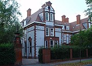 Salisbury Street house (George Gilbert Scott Jnr.)


Green plaques

The Avenues and Pearson Park Residents Association[36] operate a series of Green Plaques in the area to mark where famous residents lived. The first and second plaques were erected in honour of the actor Ian Carmichael[37] and crime writer and poet Dorothy L. Sayers,[38] respectively. Others celebrated in the area include female pilot Amy Johnson,[39] poet and librarian Philip Larkin,[40] film producer Anthony Minghella,[41] Titanic fourth officer and survivor Joseph Groves Boxhall,[42] curator Thomas Sheppard,[43] marine artist Thomas Somerscales,[44] socialist and historian John Saville, artist James Neal, film directors Ralph Thomas and Gerald Thomas,[45] playwright Alan Plater CBE, writer and publisher of Philip Larkin's books Jean Hartley[46] and pioneering female cinematographer Kay Mander.
There is a neighbourhood map detailing all the famous people that lived in the area and the address of their houses. See external links.
See also
- List of areas in Kingston upon Hull
- Trams in Kingston upon Hull, Trolleybuses in Kingston upon Hull, Hull Botanic Gardens railway station; transport links on Princes Avenue
Notes
- ^ The name Newlands arose from the land reclamation in the 12th century which formed 'new lands'. Tofts is from the Norse meaning the site of houses.[citation needed]
- ^ David Parkinson Garbutt, of Malborough House, Anlaby Road; married Mary Ann, daughter of successful fish trader, originally of Yarmouth. Garbutt's business interests included shipbuilding (business liquidated c. 1883), shipowning, and building development – he also developed an estate in Romford, Essex, and the Newington Waterworks, Hull. A Wesleyan, and promoter of the temperance movement. Died 15 November 1917, aged 70.[6]
- ^ No. 109, Park Avenue was also a listed structure, de-listed in 2003.[8]
- ^ From 1920 used as a school for physically handicapped children; later an arts and craft college; used for civil defence during the Second World War; later used for teacher training.[9] After 1986 the building was used as an adult education centre.[10]
- ^ Inspired by the Froebel Institute in London (see Friedrich Fröbel); where one of the founders had been trained,[11] as of 2013 the school is still in existence.[12]
- ^ Destroyed during the Second World War a replacement was built in 1956.[13]
- ^ Chanterlands Avenue did not exist in 1875; it grew northward from Spring Bank West from the first decade of the 20th century onwards, connecting with the western edge of the Avenues by 1908.[19]
- ^ In 1996 the Park Avenue fountain was damaged in a car accident and replaced with a replica.[27]
References
- ^ "Avenues Open Up". Hull in print. Hull City Council. Archived from the original on 7 October 2011. Retrieved 14 August 2011.
- ^ "Froebel House School". Froebel House School. Retrieved 28 March 2020.
- ^ a b c d e f "Urban Conservation and Design : Avenues/Pearson Park Conservation Area : Character Statement for the Avenues part of the above area" (PDF). Hull City Council. Archived from the original (PDF) on 4 April 2012. Retrieved 14 August 2011.
- ^ "Spring Bank West Conservation Area Character Statement" (PDF). Hull City Council. Retrieved 14 August 2011.
- ^ Ordnance Survey, 1855–6, 1:10,560. Sheets 226, 240
- ^ Barwick et al. 1989, pp. 14–15.
- ^ Sources:
- Historic England. "1, Salisbury Street (1219104)". National Heritage List for England. Retrieved 13 November 2013.
- Historic England. "3 and 5, Salisbury Street (1197691)". National Heritage List for England. Retrieved 13 November 2013.
- Historic England. "7, Salisbury Street (1291635)". National Heritage List for England. Retrieved 13 November 2013.
- Historic England. "107, Park Avenue (1218442)". National Heritage List for England. Retrieved 13 November 2013.
- Historic England. "International House (96 & 98, Westbourn Avenue) (1197673)". National Heritage List for England. Retrieved 13 November 2013.
- ^ "No.109, Park Avenue". British Listed Buildings. Archived from the original on 2 October 2012. Retrieved 15 August 2011.
- ^ Barwick et al. 1989, p. 38.
- ^ "Education centre celebrates 25 years of teaching in city". Hull Daily Mail. 12 January 2012. Retrieved 15 November 2013.
- ^ Barwick et al. 1989, Froebel House, pp. 37–38.
- ^ "Froebel House Preparatory School". www.froebelhouse.co.uk. Retrieved 15 November 2013.
- ^ a b Neave, Susan (June 2008). Hull (NW) 1909, Yorkshire Sheet 226.14. Old Ordnance Survey Maps (reprint ed.). Alan Godfrey Maps. ISBN 978-1-84784-156-8.
- ^ a b c Kingston Upon Hull Corporation Transport : A Brief History, alternative sources :
- Morfitt, Paul. "Kingston Upon Hull Corporation Transport : A Brief History". www.hullcitytransport.co.uk. Retrieved 4 March 2011.
- Morfitt, Paul. "Kingston Upon Hull Corporation Transport : A Brief History". www.freewebs.com. Retrieved 4 March 2011.
- ^ Barwick et al. 1989, p. 26.
- ^ "Dukeries Area Residents' Association". Dukeries Area Residents' Association. 2013.
- ^ a b Ordnance Survey, 1911, 1:10,560
- ^ Ordnance Survey, 1928, 1:2,500
- ^ Barwick et al. 1989, pp. 17–20.
- ^ Historic England. "Elim Pentecostal Church and adjoining Sunday School and boundary wall (Princes Avenue) (1297025)". National Heritage List for England. Retrieved 13 November 2013.
- ^ "The Records of Fish Street Congregational Church". Hull History Centre. Retrieved 24 November 2016.
- ^ "About Us". Church on The Way, Hull – An Elim Pentecostal Church. Retrieved 24 November 2016.
- ^ Historic England. "Methodist Church Tower (1197681)". National Heritage List for England. Retrieved 13 November 2013.
- ^ Barwick et al. 1989, p. 26.
- ^ Gibson, Paul. "A short history of Hull's fountains". www.paul-gibson.com. Archived from the original on 10 August 2010. Retrieved 30 November 2013.
- ^ Sources:
- Historic England. "Fountain at the junction with Salisbury Street (Park Avenue fountain) (1218451)". National Heritage List for England. Retrieved 13 November 2013.
- Historic England. "Fountain at the junction with Salisbury Street (Westbourne Avenue fountain) (1219657)". National Heritage List for England. Retrieved 13 November 2013.
- ^ "History: Victoria Avenue Fountain". victoriafountain.org. 6 June 2011. Retrieved 30 November 2013.
- ^ "Fountain rescue". www.hullsangel.org. Retrieved 30 November 2013.
- ^ "Ceremony held for Hull fountain's official switch on". BBC News. 8 July 2023. Retrieved 27 October 2023.
- ^ "Former UK Systems". www.britishtrolley.org.uk. British Trolleybus Society. Retrieved 30 November 2013.
- ^ Dyson, Mark (20 April 2010). "Station Name: Botanic Gardens (Hull)". Disused Stations. Subterranea Britannica. Retrieved 31 August 2013.
- ^ Barwick et al. 1989, p. 20.
- ^ Ordnance Survey. 1:2500; 1950–1. 1:10560; 1956. 1:10000; 1971–3
- ^ "Stopping homes subsiding in Hull's leafy avenues". BBC Humberside. BBC. 2 September 2010. Retrieved 27 January 2013.
- ^ "Tree sculpture in the Avenues 1999 to 2006". www.hullsangel.org. Retrieved 30 November 2013.
- ^ "Avenues and Pearson Park Residents Association". APPRA. Retrieved 17 May 2019.
- ^ "Ian Carmichael Green Plaque in Hull". Blue Plaque Places. Retrieved 14 May 2019.
- ^ "Dorothy L Sayers writer and scholar lived here". Open Plaques. Retrieved 14 May 2019.
- ^ "Amy Johnson green plaque in Hull". Blue Plaque Places. Retrieved 14 May 2019.
- ^ "This be the place… Larkin flats to get second plaque". The Guardian. Retrieved 14 May 2019.
- ^ "Anthony Minghella green plaque in Hull". Blue Plaque Places. Retrieved 14 May 2019.
- ^ "Joseph Groves Boxhall and Titanic green plaque in Hull". Blue Plaque Places. Retrieved 14 May 2019.
- ^ "Thomas Sheppard green plaque in Hull". Blue Plaque Places. Retrieved 14 May 2019.
- ^ "Thomas Somerscales green plaque in Hull". Blue Plaque Places. Retrieved 14 May 2019.
- ^ "Ralph Thomas and Gerald Thomas green plaque in Hull". Blue Plaque Places. Retrieved 14 May 2019.
- ^ "Jean Hartley". The Guardian. Retrieved 28 March 2020.
Sources
- Barwick, Nigel; Elsom, Ken; Hotham, Nick; Kaye, Ken; Oxaal, Ivar; Purkis, Harry; Scruton, J.S.; Watkins, Gareth (1989). Ketchell, Christopher (ed.). An Illustrated History of the Avenues and Pearson Park Hull. Avenues and Pearson Park Residents Association. ISBN 0951542001.
Literature
- Ketchell, Christopher (1989). From "slough of despond" to "noble boulevard": a chronology for David Parkinson Garbutt and the Westbourne Park Estate. Local History Archives Unit. ISBN 978-1870001496.
External links
Wikimedia Commons has media related to Avenues, Kingston upon Hull.
- "APPRA ONLINE". Avenues & Pearson Park Residents' Association website
- "APPRA Famous Neighbourhood Map".
- "Princes Avenue Traders Association". www.princesavenuehull.co.uk.
- Images
- "A postcard from Hull – Princes Avenue". www.hullwebs.co.uk. Archived from the original on 20 February 2010.
- v
- t
- e
- Anlaby Park
- The Avenues
- Bransholme
- Dairycoates
- Drypool
- East Ella
- Garden Village
- Garrison Side
- Gipsyville
- Greatfield
- Inglemire
- Kingswood
- Longhill
- Marfleet
- Newland
- Newland Park
- North Carr
- Orchard Park
- Sculcoates
- Southcoates
- Stepney
- Stoneferry
- Summergangs
- Sutton Ings
- Sutton-on-Hull
- Victoria Dock Village
- West Carr
- Wilmington
- Timeline
- William Wilberforce
- First English Civil War
- Sieges of Hull
- 1642
- 1643
- William de la Pole
- John Hotham
- Cod Wars
- Hull Blitz
- Blaydes House
- Triple trawler tragedy
- Hull Castle
- Sculcoates power station
- Jews
- Hull City Council
- Guildhall
- Wards of Hull City Council
- Kingston upon Hull East
- Kingston upon Hull North
- Kingston upon Hull West and Hessle
- Humberside Police
- Humberside Fire and Rescue Service
- Humberside
- Yorkshire
- Yorkshire and the Humber
and Education
- Church of England
- Hull Minster
- St Columba
- St John's Church, Newland
- St Mary's Church
- Roman Catholic
- St Charles Borromeo
and Sport
- Arctic Corsair
- Co-op Mosaic
- Ferens Art Gallery
- Freedom Festival
- Hasholme Logboat
- Hull Comedy Festival
- Hull Fair
- Hull Maritime Museum
- Hull New Theatre
- Hull Philharmonic Orchestra
- Hull Truck Theatre
- Hull UK City of Culture 2017
- Humber Mouth
- Larkin 25
- Pride in Hull
- Queen's Gardens
- Spurn Lightship
- Streetlife Museum of Transport
- Sea of Hull
- The Deep
- Wilberforce House
- Connexin Live Arena
- Craven Park
- Hull City
- Hull F.C.
- Hull Kingston Rovers
- MKM Stadium
- The New Adelphi Club
- Anlaby Road
- Beverley Road
- Land of Green Ginger
- The Avenues
- Whitefriargate
 Category


