The Citadel, Montreal
| The Citadel, Montreal | |
|---|---|
| Montreal, Quebec, Canada | |
 | |
| Type | fortress used to defend the city |
| Site history | |
| Built | 1690 |
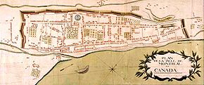
The Citadel of Montreal was a former fortress used to defend the city. It was located at what is now rue Notre-Dame between rue Bonsecours and rue Berri.
Smaller than the one in Old Quebec, the Citadel was built by the French in 1690 replacing the 1658 redoubt at Pointe-à-Callière. It consisted of a barrack structure surrounded by wood stakes palisade and located on a hill along the city's fortification wall. A cannon battery added in 1723.
The fort was demolished by the British in 1821 to allow for the extension of Notre-Dame Street.
See also
 France portal
 North America portal
 History portal


- Old Montreal
References
- Rémillard, François, Old Montreal - A Walking Tour, Ministère des Affaires culturelles du Québec, 1992.
- Albertine Ferland-Angers, La Citadelle de Montréal (1658-1820)
45°30′42″N 73°33′06″W / 45.51167°N 73.55167°W / 45.51167; -73.55167
- v
- t
- e
History of Montreal
- Hochelaga
- Fort Ville-Marie
- Notre-Dame de Montréal
- Governor of Montreal
- Hôtel-Dieu
- Saint-Sulpice Seminary
- Battle of Long Sault
- Old Montreal
- Great Peace of Montreal
- Citadel
- Grey Nuns
- 1732 earthquake
- 1870 earthquake
- Capitulation of Montreal
- American occupation
- North West Company
- Bank of Montreal
- Lachine Canal
- List of Mayors
- Burning of the Parliament
- Great Fire of 1852
- Gavazzi Riots
- Victoria Bridge
- Golden Square Mile
- Oldest buildings
- Ouimetoscope
- Richard Riot
- St. Lawrence Seaway
- Expo 67
- Black Power movement in Montreal
- Sir George Williams affair
- Murray-Hill riot
- October Crisis
- Montreal Metropolitan Commission
- Montreal Urban Community
- Blue Bird Café fire
- 1972 Montreal Museum of Fine Arts robbery
- Gargantua bar attack
- 1976 Summer Olympics
- Overdale
- École Polytechnique massacre
- Sex Garage protest
- Montreal merger
- 2011 Montreal Museum of Fine Arts theft
- Concordia University Netanyahu riot
- Dawson College shooting
- 2012 student movement
- National Historic Sites in Montreal

| Authority control databases |
|
|---|
  | This Quebec history article is a stub. You can help Wikipedia by expanding it. |
- v
- t
- e
 | This Montreal-related article is a stub. You can help Wikipedia by expanding it. |
- v
- t
- e


