Tohobit Peak
Mountain in the state of Idaho


Tohobit Peak
Location in Idaho
Show map of Idaho
Tohobit Peak
Tohobit Peak (the United States)
Show map of the United StatesRocky Mountains
Tohobit Peak is a 10,046-foot elevation (3,062 m) mountain summit located in Boise County, Idaho, United States.
Description
Tohobit Peak is part of the Sawtooth Range which is a subset of the Rocky Mountains.[4] The peak ranks as the 16th-highest in Boise County.[2] The mountain is situated 11 miles (18 km) southwest of Stanley, Idaho, in the Sawtooth Wilderness on land managed by Boise National Forest. Precipitation runoff from the mountain's slopes drains to the South Fork Payette River via Baron and Goat creeks. Topographic relief is significant as the summit rises 3,450 feet (1,050 meters) above Baron Creek in 1.1 mile (1.8 km) and 3,150 feet (960 meters) above Goat Creek in 0.85 mile (1.37 km). The first ascent of the summit was made in 1985 by Steve Grantham, Dave Ferguson, Ken Ferguson and Mike Crist via the West Ridge using a Goat Creek approach.[1] "Tohobit" is a Native American word for "black."[1] This landform's toponym has been officially adopted by the United States Board on Geographic Names.[3]
Climate
Based on the Köppen climate classification, Tohobit Peak is located in an alpine subarctic climate zone with long, cold, snowy winters, and cool to warm summers.[5] Winter temperatures can drop below −10 °F with wind chill factors below −30 °F.
See also
- List of mountain peaks of Idaho
 Mountains portal

Gallery
-
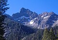 North face
 -
 North aspect of Tohobit Peak centered.


References
- ^ a b c d e "Idaho: A Climbing Guide, Tohobit Peak". idahoaclimbingguide.com. Retrieved 2023-09-18.
- ^ a b c d "Tohobit Peak - 10,046' ID". listsofjohn.com. Retrieved 2023-09-18.
- ^ a b "Tohobit Peak". Geographic Names Information System. United States Geological Survey, United States Department of the Interior. Retrieved 2023-09-18.
- ^ "Tohobit Peak, Idaho". Peakbagger.com. Retrieved 2023-09-18.
- ^ Peel, M. C.; Finlayson, B. L.; McMahon, T. A. (2007). "Updated world map of the Köppen−Geiger climate classification". Hydrol. Earth Syst. Sci. 11: 1633–1644. ISSN 1027-5606.
External links
- Tohobit Peak: Idaho: A Climbing Guide
- Tohobit Peak: weather forecast
- v
- t
- e
- Cache Peak
- Graham Peak
- Mount Harrison
- Mount Independence
- Smoky Mountain
- Thunder Mountain
| Centennial Mountains |
|
|---|---|
| Clearwater Mountains |
- Steel Mountain
- Trinity Mountain
- Two Point Mountain
- Boulder Peak
- Cerro Ciento
- Easley Peak
- Glassford Peak
- Kent Peak
- Ryan Peak
| Selkirk Mountains |
|
|---|
- Bell Mountain
- Big Boy Peak
- Big Creek Peak
- Diamond Peak
- Flatiron Mountain
- Little Diamond Peak
- Nicholson Peak
- The Riddler
- Shoshone John Peak
- Borah Peak
- Donaldson Peak
- Leatherman Peak
- Little Regret Peak
- Lost River Peak
- Mount Breitenbach
- Mount Church
- Mount Idaho
- Mount McCaleb
- No Regret Peak
- USGS Peak
- Altair Peak
- Angel's Perch
- Brocky Peak
- Cobb Peak
- Devils Bedstead East
- Duncan's Peak
- Goat Mountain
- Hyndman Peak
- Old Hyndman Peak
- Pegasus Peak
- Pioneer Mountain
- Pyramid Peak
- Salzburger Spitzl
- Smiley Mountain
- Standhope Peak
- Alpine Peak
- Baron Peak
- Braxon Peak
- Cirque Lake Peak
- Dave's Peak
- Decker Peak
- El Capitan
- Elk Peak
- Grand Mogul
- Horstmann Peak
- Imogene Peak
- McDonald Peak
- McGowan Peak
- Merritt Peak
- Mickey's Spire
- Moolack Mountain
- Monte Verita
- Mount Carter
- Mount Cramer
- Mount Heyburn
- Mount Iowa
- Mount Limbert
- Mount Regan
- North Raker
- Packrat Peak
- Parks Peak (Blaine County)
- Payette Peak
- Sevy Peak
- Snowyside Peak
- Thompson Peak
- Warbonnet Peak
- Williams Peak (Custer County)
- Backdrop Peak
- Baker Peak
- Bald Mountain
- Bear Peak
- Big Peak
- Bromaghin Peak
- Buttercup Mountain
- Camas County Highpoint
- Carbonate Mountain
- Dollarhide Mountain
- Griffin Butte
- Kelly Mountain (Blaine County)
- Lower Titus Peak
- Mahoney Butte
- Norton Peak
- Paradise Peak
- Prairie Creek Peak
- Saviers Peak
- Skillern Peak
- Titus Peak
- Boardman Peak
- Iron Mountain
- Smoky Dome
- Snowbank Mountain
- Bible Back Mountain
- Blackmon Peak
- Calkins Peak
- Castle Peak
- Chinese Wall
- Croseus Peak
- D. O. Lee Peak
- Ebony Peak
- Fourth of July Peak (Custer County)
- Horton Peak
- Lonesome Lake Peak
- Lookout Mountain
- Merriam Peak
- Patterson Peak (Custer County)
- Peak 11,272
- Washington Peak
- Watson Peak (Custer County)
- White Cloud Peak 1
- White Cloud Peak 2
- White Cloud Peak 3
- White Cloud Peak 4
- White Cloud Peak 5
- White Cloud Peak 6
- White Cloud Peak 7
- White Cloud Peak 8
- White Cloud Peak 9
- White Cloud Peak 10
- Bear River Mountains
- Big Dick Point
- Blackfoot Mountains
- Brundage Mountain
- Caribou Mountains
- Chinese Peak
- Cotterel Mountains
- Devils Throne
- Devils Tooth
- Dirty Head
- Granite Peak
- Hoodoo Mountains
- Jim Sage Mountains
- Kings Peak
- The Ogre
- Owyhee Mountains
- Potato Hill
- Portneuf Range
- Puddin Mountain
- Ranger Peak
- Salmon River Mountains
- Seven Devils Mountains
- Shadow Butte
- She Devil
- Twin Imps
Places adjacent to Tohobit Peak | ||||||||||||||||
|---|---|---|---|---|---|---|---|---|---|---|---|---|---|---|---|---|
| ||||||||||||||||


